
 Worksheets
South America Global Location
Total questions: 23
Worksheet time: 12mins
Name
Class
Date
1.

a)
Argentina
b)
Brazil
c)
Bolivia
d)
Uruguay
2.

a)
Argentina
b)
Bolivia
c)
Brazil
d)
Venezuela
3.

a)
Venezuela
b)
Colombia
c)
Ecuador
d)
Peru
4.

a)
Venezuela
b)
Colombia
c)
Ecuador
d)
Peru
5.

a)
Peru
b)
Chile
c)
Bolivia
d)
Paraguay
6.

a)
Bolivia
b)
Paraguay
c)
Peru
d)
Chile
7.

a)
Venezuela
b)
Colombia
c)
Ecuador
d)
Peru
8.

a)
Bolivia
b)
Paraguay
c)
Uruguay
d)
Argentina
9.

a)
Venezuela
b)
Colombia
c)
Ecuador
d)
Peru
10.

?
a)
Colombia
b)
Venezuela
c)
Brazil
d)
Chile
11.

?
a)
French Guiana
b)
Suriname
c)
Venezuela
d)
Guyana
12.

?
a)
Guyana
b)
Suriname
c)
French Guiana
d)
Chile
13.

?
a)
Guyana
b)
French Guiana
c)
Surimane
d)
Colombia
14.
Which country has coastline on both the Atlantic and Pacific Oceans?
a)
Venezuela
b)
Colombia
c)
Brazil
d)
Peru
15.
Capital of Brazil
a)
Brasilia
b)
Quito
c)
Bogota
d)
Lima
16.

What is the capital of Colombia?
a)
Caracas
b)
Bogota
c)
Quito
d)
Malabo
17.

What is the capital of Argentina?
a)
Buenos Aires
b)
Montevideo
c)
Madrid
d)
Caracas
18.

What is the capital of Peru?
a)
Lima
b)
Quito
c)
Madrid
d)
Buenos Aires
19.
Which map best shows the location of tropical rainforests?
a)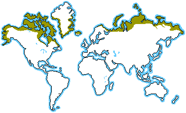
b)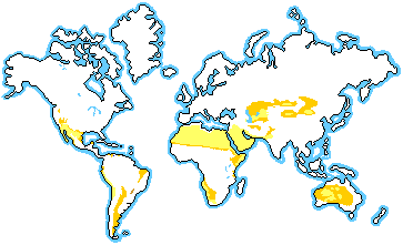
c)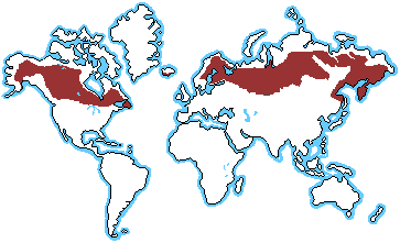
d)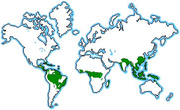
20.
The name of the biggest rainforest is _________
a)
The Amazon
b)
The Congo
c)
The Daintree
d)
The Amazing
21.

What important imaginary line of latitude is this shown in red?
a)
Prime Meridian
b)
Equator
c)
International Date Line
22.

Which is found near the "7" on the map?
a)
Amazon River
b)
Gulf River
c)
Pacific Ocean
d)
Flint River
23.

Identify the location of the feature on the map.
a)
Mount Rushmore
b)
Andes Mountain
c)
Amazon River
d)
Sierra Madre Mountains
100 %

