
 Worksheets
Topographic Maps Practice
Total questions: 20
Worksheet time: 3600secs
Name
Class
Date
1.
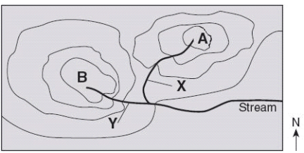
Which direction is the stream flowing?
a)
northward
b)
southward
c)
westward
d)
eastward
2.

How many peaks are on the map? (hill tops)
a)
4
b)
3
c)
2
d)
1
3.
It is steep on a topographic map where __________.
a)
lines are closest together
b)
a river flows into a lake
c)
contours bend
d)
contours are far apart
4.

What are the darker lines called?
a)
roads
b)
index contour
c)
contour interval
d)
waves
5.

Determine the contour interval:
a)
5 m
b)
10 m
c)
15 m
d)
20 m
6.

If we were in a plane, Path B --> C is about the same distance as path E --> N. But, which path is the easier walk?
a)
B --> C is the easier walk
b)
E --> N is the easier walk
c)
B --> C and E --> N are the same walking distance
7.

What is the contour interval of the topographic map below?
a)
400 m
b)
200 m
c)
100 m
d)
80 m
8.
When you move from one contour line to another, the elevation
a)
stays the same
b)
goes up or down
c)
disappears
d)
is below sea level
9.
If contour lines are close together, then the slope is
a)
gentle
b)
steep
c)
flat
d)
going up and down
10.
The height above sea level is called
a)
topographic
b)
contour
c)
elevation
d)
depth
11.
What is melted rock called that is below the Earth's surface?
a)
lava
b)
magma
c)
fossils
d)
crust
12.
What is melted rock called that is erupting from Earth's surface?
a)
lava
b)
magma
c)
fossils
d)
sedimentary rock
13.
Volcanic eruptions create new land by adding
a)
gases to the air
b)
heat to the soil
c)
new rock to Earth's surface
d)
water vapor to the air
14.
The outer layer of Earth's surface made of solid rock is called the
a)
mantle
b)
magma
c)
crust
d)
core
15.
Water flows fastest when
a)
there is a steep slope
b)
there is a gentle slope
c)
there is a long distance
d)
it has to move around boulders
16.

Match the topographic map to its profile.
a)
b)
c)
d)
17.

Match the topographic map to its profile picture.
a)
b)
c)
d)
18.

What is the elevation of point B?
a)
800 ft
b)
850 ft
c)
900 ft
d)
1000 ft
19.

What is the difference in elevation between Point X and Point Y?
a)
120 m
b)
240 m
c)
360 m
d)
340 m
20.
What questions do you have about reading and understanding topographic maps?
4 lines
100 %

