wayground logo

Free Printable Worksheets

NEW

Font size

S
M
L
XL
Worksheets

Map Skills Review - NFMS 6th Grade

Total questions: 42

Worksheet time: 44mins

Name
Class
Date
1.

Latitude measure ____________ of the equator

a)

East to West

b)

North to South

2.
This line measures 0 degrees longitude:
a)
Equator
b)
International Date Line
c)
Meridians
d)
Prime Meridian
3.
The 0 degree line of latitude is the ___________.
a)
Equator
b)
Prime Meridian
c)
International Date Line
d)
Contour line
4.
What is the reason why latitude lines NEVER intersect? 
a)
They converge at the poles
b)
They are cool
c)
They are vertical lines 
d)
They are parallel
5.
What is this object known as?
a)
map symbol
b)
map key
c)
map scale
d)
compass rose
6.
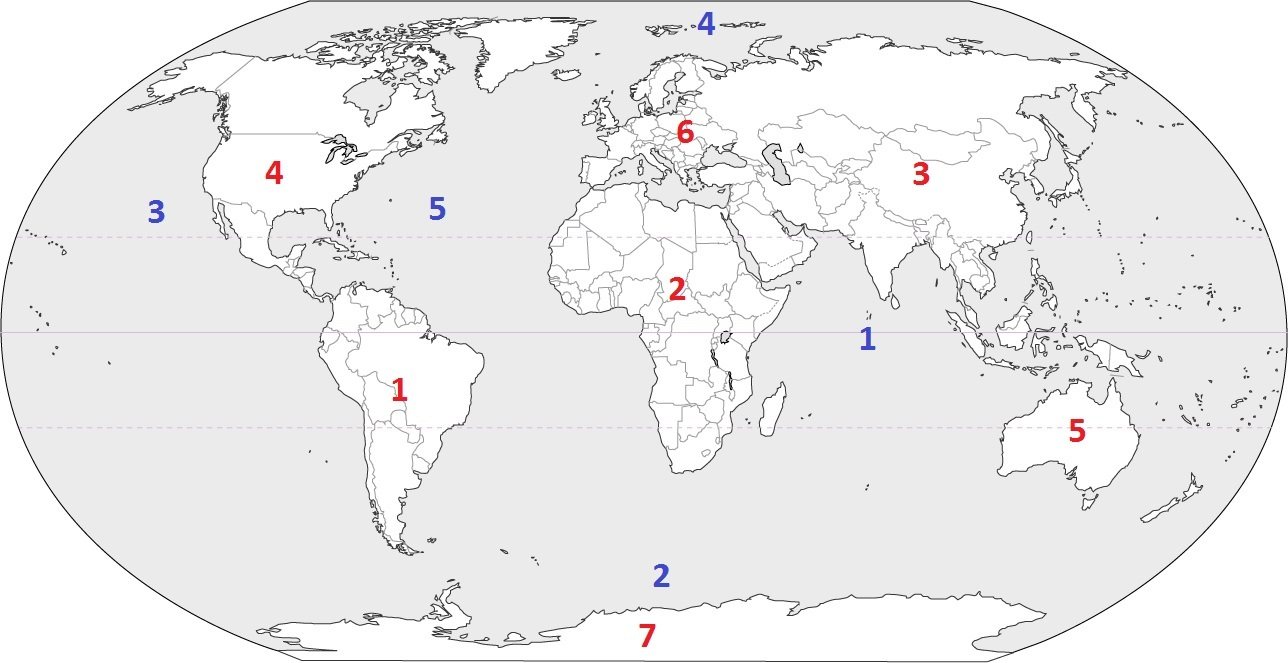
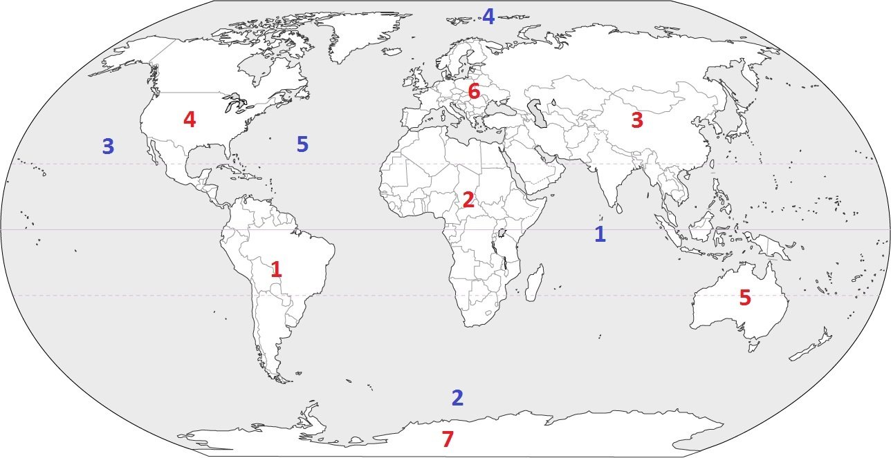
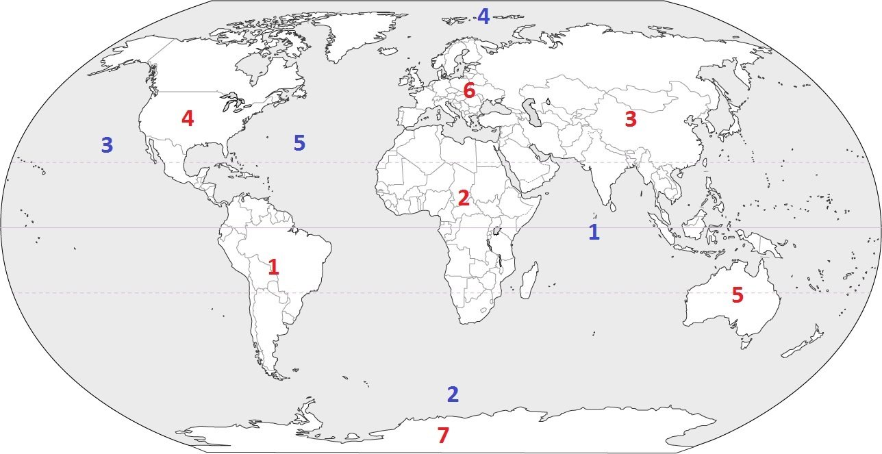
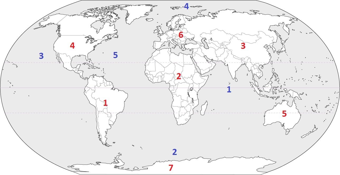
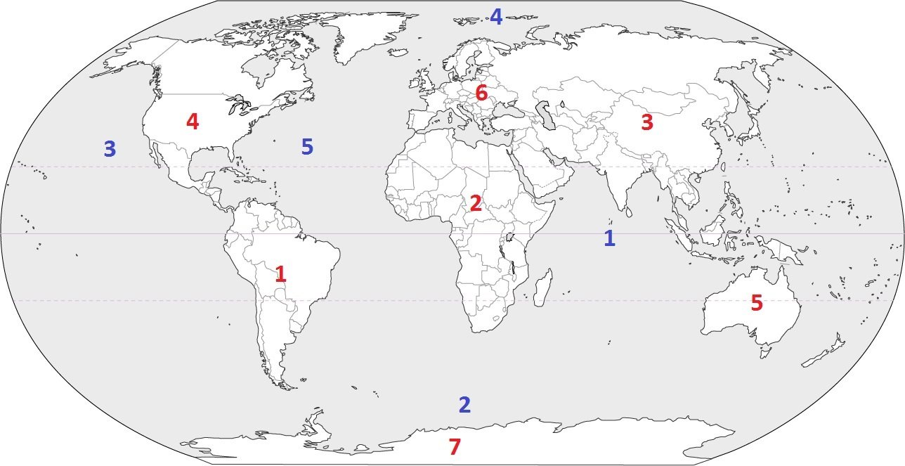
Name Continent C!
a)
Antarctica
b)
Europe
c)
Asia
d)
North America
7.
Continent F is ________.
a)
Antarctica
b)
Australia
c)
Europe
d)
North America
8.
Name Ocean #1!
a)
Indian
b)
Pacific
c)
Atlantic
d)
Southern
9.
Ocean #4 is ________.
a)
Indian
b)
Atlantic
c)
Pacific
d)
Southern
10.
What direction is indicated by the number 5?
a)
northeast
b)
northwest
c)
southeast
d)
southwest
11.
What is a map scale?
a)
a tool to measure distance
b)
a tool to tell direction
c)
a tool to start a fire
d)
a tool to build a house
12.

What kind of map is this?

a)

Physical

b)

Political

c)

Globe

13.

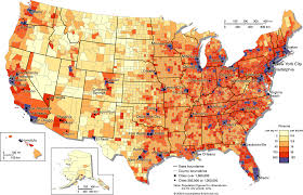
Identify this map.

a)

Population density map

b)

Physical Map

c)

Road map

14.

What type of map is this?

a)

Political

b)

Physical

c)

Economic Activity

15.
How many states are in the U.S.?
a)
25
b)
100
c)
50
d)
3
16.
How many continents are there?
a)
4
b)
1
c)
5
d)
7
17.
The equator divides what two hemispheres?
a)
East and West
b)
North and South 
18.
An imaginary line that divides the eastern and western hemispheres?
a)
equator
b)
longitude
c)
latitude
d)
prime meridian
19.
Which of the following is NOT a cardinal direction?
a)
North
b)
West
c)
Southeast
d)
East
20.
What do we call directions that come between the cardinal directions?
a)
Primary Directions
b)
Intermediate Directions
c)
Middle Directions
d)
Subdirections
21.

This type of map shows physical features of an area such as mountains, rivers and lakes.

a)

Political Map

b)

Physical Map

c)

Road Map

22.

This is the place on the map where the symbols are defined.

a)

Title

b)

Legend

c)

Scale

23.

This is a small ruler on the map that shows what real-life distance is represented by a certain length on the map.

a)

Legend

b)

Title

c)

Scale

24.

This type of map shows state and national boundaries as well as large and small cities.

a)

Road Map

b)

Physical Map

c)

Political Map

25.
HORIZONTAL lines (like the Equator) are also called...
a)
Lines of Latitude
b)
Lines of Longitude
26.
VERTICAL lines (like the Prime Meridian) are also called...
a)
Lines of Latitude
b)
Lines of Longitude
27.

Which lines measure North and South of the Equator?

a)

Latitude

b)

Longitude

28.

Which lines measure East and West of the Prime Meridian?

a)

Latitude

b)

Longitude

29.
When you record coordinates, which line MUST be listed first?
a)
Latitude
b)
Longitude
30.
What type of map is pictured?
a)
Political
b)
Physical
c)
Thematic
31.
What type of map is pictured?
a)
Political
b)
Physical
c)
Thematic
32.
What type of map is pictured?
a)
Political
b)
Physical
c)
Thematic
33.
What is the title of the map?
a)
Legends of the United States
b)
Heat Waves in the United States
c)
Roller Coasters in the United States
34.
What lines are pictured?
a)
Latitude
b)
Longitude
35.
What lines are pictured?
a)
Latitude
b)
Longitude
36.
How many oceans are there in the world?
a)
7
b)
6
c)
5
d)
4
37.
Which is the largest continent in the world?
a)
Asia
b)
Africa
c)
North America
d)
Antarctica
38.
Identify the ocean at location #3
a)
Atlantic Ocean
b)
Arctic Ocean
c)
Pacific Ocean
d)
Indian Ocean
39.
Identify the ocean at location #5
a)
Atlantic Ocean
b)
Southern Ocean
c)
Pacific Ocean
d)
Arctic Ocean
40.
Identify the ocean at location #2
a)
Indian Ocean
b)
Pacific Ocean
c)
Southern Ocean
d)
Arctic Ocean
41.
Identify the ocean at location #1
a)
Southern Ocean
b)
Arctic Ocean
c)
Atlantic Ocean
d)
Indian Ocean
42.
Identify the ocean at location #4
a)
Indian Ocean
b)
Pacific Ocean
c)
Arctic Ocean
d)
Atlantic Ocean