wayground logo

Free Printable Worksheets

Font size

S
M
L
XL
Worksheets

Unit Test: Geography, Continents, Maps, Oceans, Root Words

Total questions: 103

Worksheet time: 2hrs 30mins

Name
Class
Date
1.
What is the name of this line at 0 degrees latitude?
a)
Prime Meridian
b)
Equator
c)
North Pole
d)
South Pole
2.
What is the name of the line at zero degrees longitude?
a)
Equator
b)
Prime Meridian
c)
North Pole
d)
South Pole
3.
What is the approximate location of letter B?
a)
80oN, 0o
b)
0o, 80oW
c)
80oS, 0o
d)
0o, 80oE
4.
a)
The map show the lines of longitude.
b)
The map shows the lines of latitude.
5.
a)
The map shows lines of longitude.
b)
The map shows lines of latitude.
6.
The Prime Meridian separates the Earth into what two hemispheres?
a)
Northern and Southern
b)
Western and Eastern
c)
Northern and Eastern
d)
Southern and Western
7.

The girl is pointing to the East with her ____________ hand.

a)

left

b)

right

c)

front

d)

small

8.

The girl is pointing to the West with her __________hand.

a)

left

b)

right

c)

front

d)

small

9.
Shape of the earth
a)
Hemisphere 
b)
Equator
c)
Sphere
d)
Rotation
10.
This helps you find directions on a map
a)
Compass Rose
b)
Scale
c)
Grid System
d)
Longitude 
11.
This type of map focuses on one main topic.
a)
Political
b)
Physical
c)
Thematic
d)
Global
12.
This type of map shows natural features
a)
Political
b)
Physical
c)
Thematic
d)
Grid System
13.
Half of the earth
a)
Sphere
b)
Hemisphere
c)
Equator
d)
Prime Meridian
14.
This type of map shows boundaries
a)
Political
b)
Physical
c)
Thematic
d)
Global
15.

The large land masses on the earth are called

a)

Continents

b)

Oceans

c)

Countries

d)

Plains

16.

Explains what the symbols on a map stand for.

a)

Map legend (key)

b)

scale

c)

compass rose

d)

global grid

17.

How people, goods, and ideas move to and from a place.

a)

location

b)

human environment interaction

c)

movement

d)

place

e)

region

18.

Latitude are imaginary lines that circle the earth from

a)

East to West

b)

North to South

c)

Asia to Australia

d)

America to Mexico

19.
What are the 5 Themes of Geography?
a)
Region, Human-Environment Interaction, Location, Climate, and Place
b)
Region, Human-Environment Interaction, Movement, Place, and Location
c)
Place, Movement, Location, Region, and Human-Alien Interactions
d)
Absolute Location, Relative Location, Climate, Vegetation, and Movement 
20.
The statement:  "The Eiffel Tower is located at 48.8584° N, 2.2945° E," is an example of which of the 5 Themes of Geography?
a)
Movement
b)
Region
c)
Place
d)
Location
21.
Syrian refugees fleeing the Middle East into Europe and sanctuary countries around the world is an example of which of the 5 Themes of Geography?
a)
Place
b)
Location
c)
Movement
d)
Human-Environment Interaction
22.
What is the acronym that can be used to "help" you remember the 5 Themes of Geography?
a)
MR. HELP
b)
MS. HELP
c)
MR. HIP
d)
MRS. HEL
23.
Australia is located to the west of New Zealand..... this is a statement representing which of the 5 Themes of Geography?
a)
Place
b)
Location
c)
Movement
d)
Human-Environment Interaction
24.
Which of the 5 Themes of Geography is being represented in this picture?
a)
Location
b)
Region
c)
Movement
d)
Place
25.
Relative location is:
a)
Latitude and Longitude
b)
Given by GPS
c)
a general location, not specific
d)
a specific place:
26.
Absolute location is:
a)
general
b)
not used on GPS
c)
is saying that Two Rivers is in East Hartford
d)
uses latitude and longitude to give a specific area
27.
Cutting down trees to build houses is an example of which?
a)
Location
b)
Place
c)
Human-Environment Interaction
d)
Movement
28.
The states in the area known as the "Southwest" of the United States are often grouped together because they are very hot and dry desert-like areas.
a)
Region
b)
Location
c)
Human Environment Interaction
d)
Movement
29.
Which of the following is NOT a theme of geography?
a)
place
b)
location
c)
history
d)
human-environment interaction
30.
People cutting down trees, creating watersheds, draining wetlands and polluting soil are all examples of this theme.
a)
regions
b)
movement
c)
human-environment interaction
d)
location
31.
The theme of geography that answers the question “How do goods, ideas, and people get  from one area to another is called ?
a)
Region
b)
Place
c)
Human Environment Interaction
d)
Movement
32.
The theme of geography that describes what it is like to live there using an area’s physical and  human characteristics is
a)
Region
b)
Place
c)
Human Environment Interaction
d)
Movement
33.
How do we modify the environment?
a)
We build irrigation ditches
b)
We build landfills
c)
We build dams
d)
All of the above
34.
Only people move.
a)
True
b)
False
35.

A cultural regions have similar or common features such as food, clothing, the way people talk, etc.

a)

True

b)

False

36.

Which of the following is an example of non-physical movement?

a)

Going to the store to get shoes.

b)

Buying the shoes.

c)

Getting the idea to buy a pair of shoes that you saw on a t.v. commercial.

d)

Shoes being shipped to your house.

37.
What is the question for movement?
a)
Where is it?
b)
How do people and ideas get around?
c)
What does it look like?
38.
What does it look like when you get there? What theme of geography is this?
a)
Place
b)
Location
c)
Region
d)
Human environment interaction
39.
What is the question for Region?
a)
Where it is?
b)
What does it look like when you get there?
c)
What do locations have in common?
d)
What do people do to the environment?
40.

Which of the following is an example of absolute location?

a)

Take a right on Man O'War BLVD and then a left at Walmart.

b)

My house is located at 80.00235 degrees north and 32.1774 degrees east.

c)

Turn right out of Hayes parking lot and then left at the big tree.

d)

Turn right at the second stop light and then stay straight for 3.2 miles.

41.
a)
Movement
b)
Region
c)
Human-Environment Interaction
d)
Location
42.
People in New York use the underground subway to get around
a)
Place
b)
Location
c)
Movement
d)
Region
43.
The rocky mountain states include Idaho, Montana, Colorado, Nevada, New Mexico, and Utah
a)
Human Environment Interaction
b)
Movement
c)
Absolute Location
d)
Region
44.
Austin, Texas is located at 30 degrees N, 90 degrees W
a)
Absolute location
b)
Relative location
c)
place
d)
region
45.
The United States imports a great deal of products from other countries
a)
Region
b)
Relative Location
c)
Movement
d)
Human environment interaction
46.
Oklahoma is north of Texas
a)
Movement
b)
Relative Location
c)
Absolute Location
d)
Region
47.
This picture shows which of the 5 Themes of Geography?
a)
Movement
b)
Region
c)
Human-Environment Interaction
d)
Location
48.
Which of the 5 Themes of Geography is being represented in this picture?
a)
Location
b)
Region
c)
Movement
d)
Place
49.

Which is an example of Relative location?

a)

Lincoln High is across the street from McDonald's

b)

Lincoln High is located at 40 degrees N, 96 degrees W

c)

The U.S. Capitol is 38° 53′ 35″ N, 77° 00′ 32″ W

d)

4055 Mockingbird Court

50.

Choose the physical features that describe a place (3 answers)

a)

climate

b)

language

c)

bodies of water

d)

vegetation

51.

Choose all of the human features that describe place (3)

a)

religion

b)

government

c)

landforms

d)

food

52.

What is the name of our world?

(a)  

53.

What is the name of the continent we live in?

a)

North America

b)

Africa

c)

South America

d)

North Carolina

54.

What is the name of our country?

a)

Mexico

b)

The United States of America

c)

Africa

d)

North Carolina

55.

What is the name of the state we live in?

a)

Virginia

b)

Hickory

c)

Charlotte

d)

North Carolina

56.

What county do we live in?

a)

Iredell

b)

Newton

c)

Hickory

d)

Catawba

57.

What city do we live in?

a)

Catawba

b)

Catawba Valley

c)

Hickory

d)

Conover

58.

Which of the following would be considered a town?

a)

Charlotte

b)

Claremont

c)

Hickory

d)

Raleigh

59.

This is an example of a community?

a)

Grandview School

b)

Catawba

c)

Ridgeview (Brown Penn Rec. Center)

d)

Both Grandview and Ridgeview

60.
Imaginary lines that run north and south but are measured east and west
a)
Grid System
b)
Scale
c)
Latitude
d)
Longitude
61.
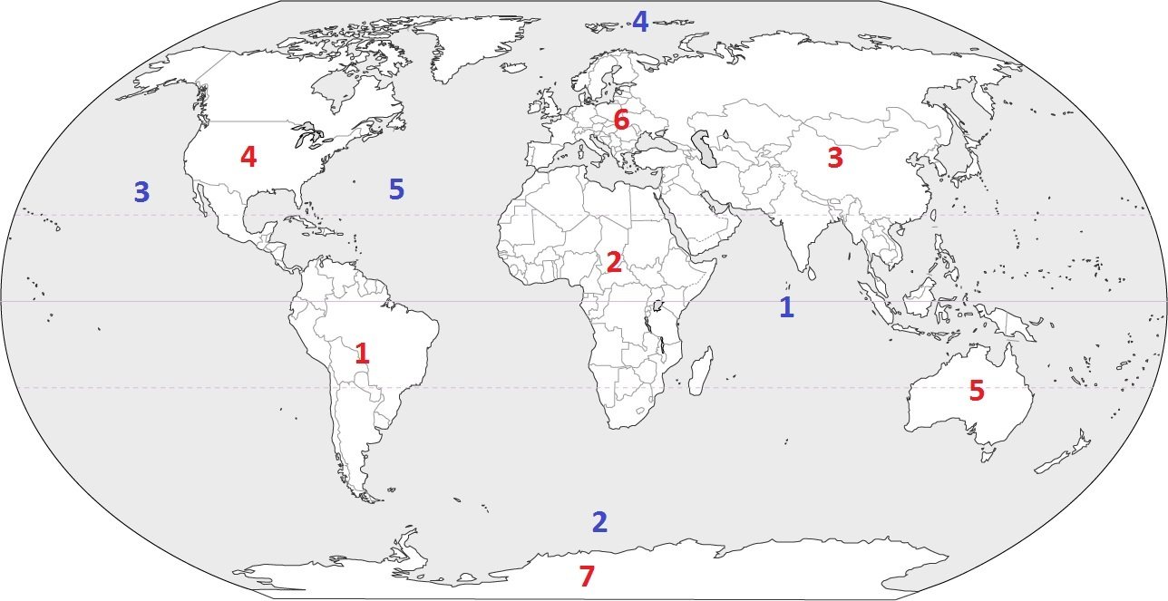
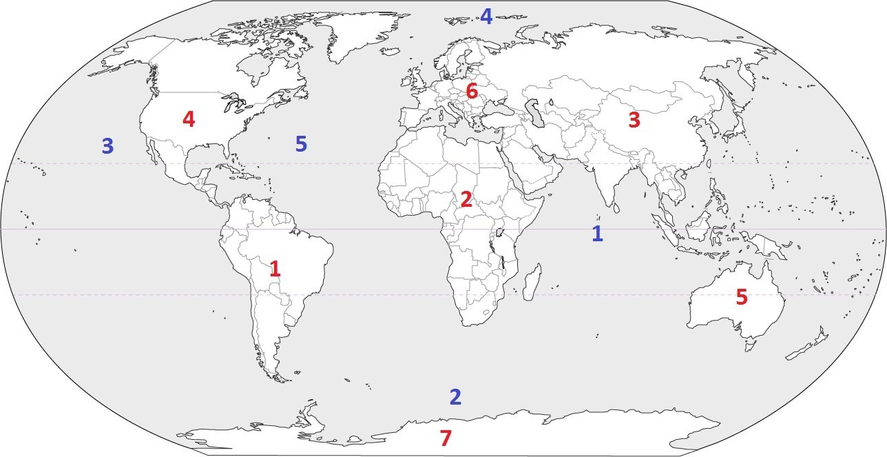
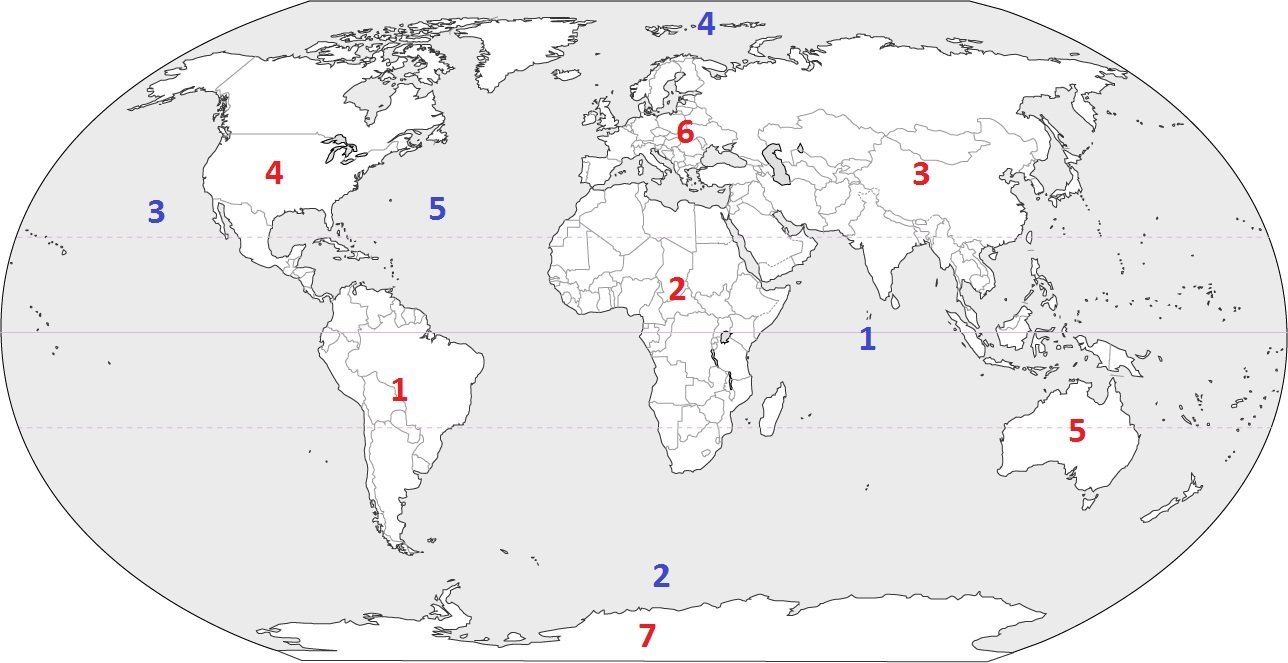
Which continent is located at #4?
a)
South America
b)
North America
c)
Europe
d)
Africa
62.
Which continent is located at #1?
a)
North America
b)
Antarctica
c)
South America
d)
Asia
63.
Which continent is located at #2?
a)
Africa
b)
South America
c)
Australia
d)
Europe
64.

Which continent is home of the Sahara Desert and would more than likely be considered the hottest?

a)

South America

b)

Europe

c)

Africa

d)

Australia

65.
On this continent, you can find animal species such as penguins, seals and some birds. This is the coldest continent.
a)
North America
b)
Antarctica
c)
South America
d)
Europe
66.
This is the smallest continent, farthest away from the others where you may find koalas and kangaroos.
a)
Europe
b)
Africa
c)
South America
d)
Australia
67.

Name the red continent!

a)

North America

b)

Africa

68.

How many major oceans are there in the world?

a)

4

b)

5

c)

3

d)

7

69.

All of the following are major oceans EXCEPT:

a)

Atlantic Ocean

b)

Pacific Ocean

c)

Southern Ocean

d)

African Ocean

e)

Indian Ocean

70.

Was this test easy or hard?

a)

easy

b)

hard

71.

I am a Caribbean nation.

I am located west of the Dominican Republic but east of Jamaica.

I am located not far from Florida to the southeast.

What am I?

a)

Cuba

b)

Bahamas

c)

Mexico

d)

Haiti

72.

Which set of coordinates is the absolute location of H?

a)

15°S, 100°W

b)

15°S, 75°E

c)

45°S, 75°W

d)

15°N, 100°W

73.

Look at the graph above. Which of the following statements is true about

the month of August?

a)

There are about 6 inches of rain with a temperature of about 80 degrees.

b)

There are about 6 inches of rain with a temperature of about 50 degrees.

c)

There are about 8 inches of rain with a temperature of about 60 degrees.

d)

There are about 8 inches of rain with a temperature of about 50 degrees.

74.

4. A region is a group of places that are (check all that apply)

a)

Like each other

b)

Far from each other

c)

Near each other

d)

Have little in common with each other

75.

7. According to the climograph below, when is the dry season in this location?

a)

May to October

b)

August to December

c)

November to April

d)

March to September

76.

What are the seven continents?

a)

California, Nevada, Washington, Arizona, Utah, New Mexico, Alaska

b)

North America, South America, Europe, Africa, Asia, Australia, Antarctica

c)

Texas, Louisiana, Arkansas, Georgia, Florida, North Carolina, South Carolina

d)

New York, New Jersey, Connecticut, Rhode Island, Virginia, New Hampshire, Delaware

77.

Which is an example of humans interacting with their environment?

a)

Someone eating a fish sandwich for lunch at a fastfood restaurant.

b)

A town council raising the cost of a fishing license from $5 to $10.

c)

someone teaching Math

d)

Inuit tribes of the Arctic who depend on fishing for survival.

78.

What Continent do you live in?

a)

North America

b)

Mars

c)

South America

d)

Europe

79.
Largest continent and home of the most populated country: China. 
a)
Europe
b)
Africa 
c)
South America
d)
Asia
80.
Second largest continent. Home of the Pyramids, Sahara Desert, and the Nile River. 
a)
Asia
b)
North America
c)
Africa
d)
South America
81.
Third largest continent and home to the second largest country in the world: Canada. 
a)
North America
b)
South America
c)
Europe
d)
Austrilia
82.
Where is it exactly on the Earth?
a)
Place
b)
Perfect Location
c)
Absolute Location
d)
Relative Location
83.
Where is it in relation to other areas or things?
a)
Place
b)
Perfect Location
c)
Absolute Location
d)
Relative Location
84.
How are areas similar or united (physically, politically, or culturally) to other areas around them?
a)
Movement
b)
Absolute Location
c)
Region
d)
Place
85.
Virginia is north of North Carolina
a)
Place
b)
Absolute Location
c)
Region
d)
Relative Location
86.
Wilson Memorial High School is at 189 Hornet Rd, Fishersville, VA 22939
a)
Absolute Location
b)
Relative Location
c)
Place
d)
Region
87.
Washington D.C. is at 38.8 North Latitude and 77 West Longitude
a)
Relative Location
b)
Place
c)
Absolute Location
d)
Region
88.
Many species of birds travel south in the winter to be near warmer temperatures and then return north in the spring and summer.
a)
Human Environment Interaction
b)
Movement
c)
Region
d)
Place
89.

According to the map, Michigan is _________ of Wisconsin.

a)

North

b)

South

c)

East

d)

West

90.

According to the map, which state is west of Nevada?

a)

Utah

b)

California

c)

Idaho

d)

Arizona

91.

According to the map, which state is south of Michigan?

a)

North Dakota

b)

Indiana

c)

Wisconsin

d)

Kansas

92.

The most correct term for this object is:

a)

compass

b)

compass rose

c)

place finder

d)

GPS

93.

What is the name for the directions that are missing?

a)

intertwined

b)

intermediate

c)

inbetween

d)

intermingle

94.

What is the name for the directions that are being shown?

a)

canary

b)

cardigan

c)

cardiologist

d)

cardinal

95.

According to the map, which state is south of Kansas?

a)

Oklahoma

b)

Nebraska

c)

Colorado

d)

South Dakota

96.
The hotel is ____________ of the zoo.
a)
North 
b)
South
c)
East
d)
West
97.

Which of the following is an Intermediate Direction?

a)

North

b)

East

c)

Northeast

d)

South

98.

What is the special saying

we use to remember the cardinal

directions?

a)

even swans nest Wednesdays

b)

never eat soggy waffles

c)

we never end school

d)

every night we sing

99.

What direction is indicated by the number 6?

a)

north

b)

east

c)

south

d)

west

100.
What direction is indicated by the number 3?
a)
northeast
b)
northwest
c)
southeast
d)
southwest
101.

What country is north of the USA?

a)

Alaska

b)

Canada

c)

Mexico

d)

Cuba

102.

North America is in the________________ hemisphere.

a)

northwest

b)

northeast

c)

eastsouth

d)

northeast

103.

What country is South of the USA?

a)

Alaska

b)

Canada

c)

Mexico

d)

Cuba