wayground logo

Free Printable Worksheets

Font size

S
M
L
XL
Worksheets

Lesson 1.1 Final Practice!!!

Total questions: 43

Worksheet time: 35mins

Name
Class
Date
1.

This imaginary line at 0 degrees latitude is located in the Tropics.

(a)  

2.

Uzbekistan is south of Kazakhstan is an example of?

a)

relevant location

b)

absolute location

c)

relative location

d)

echo location

3.

Name the lines shown in the diagram.

a)

Latitude

b)

Longitude

c)

Equator

d)

Prime Meridian

4.

Is this showing latitude or longitude?

a)

Latitude

b)

Longitude

c)

Equator

d)

Prime Meridian

5.
Latitude is measured out from what?
a)
Equator
b)
Prime Merididan
c)
International Date Line
d)
United States
6.
Longitude is measured out from what?
a)
Equator
b)
Prime Meridian
c)
International Date Line
d)
United States
7.
What are the four MAIN directions on the Compass Rose?
a)
North, South, East, and West
b)
Northeast, Southeast, Northwest, Southwest
8.

The ------- divides the Earth into Northern and Southern hemisphere.

a)

Equator

b)

Prime Meridian

c)

Northern Hemisphere

d)

Southern Hemisphere

9.
What is the name of the line at zero degrees longitude?
a)
Equator
b)
Prime Meridian
c)
North Pole
d)
South Pole
10.
What is the name of this line at 0 degrees latitude?
a)
Prime Meridian
b)
Equator
c)
North Pole
d)
South Pole
11.
What is the name of a 3D sphere of the Earth.
a)
Map
b)
Globe
c)
Earth
d)
Ball
12.

The line that separates the Northern and Southern hemispheres is the

a)

Equator

b)

Prime Meridian

c)

north-south line

d)

Mason-Dixon Line

13.

The line that separates the Western and Eastern hemispheres is the

a)

Equator

b)

Prime Meridian

c)

east-west line

d)

Mason-Dixon Line

14.

Northern half of the earth is known as the _____________________ and the southern half is known as the ___________________

a)

Southern Hemisphere and Northern Hemisphere

b)

Eastern Hemisphere and Southern Hemisphere

c)

Northern Hemisphere and Southern Hemisphere

d)

Northern Hemisphere and Western Hemisphere
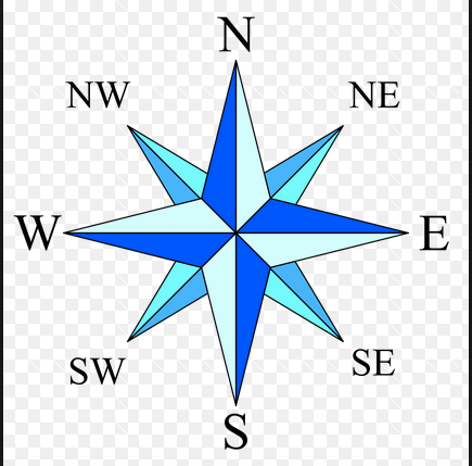
15.
What is this object known as?
a)
map symbol
b)
map key
c)
map scale
d)
compass rose
16.
a)

The graphic show the lines of longitude.

b)

The graphic shows the lines of latitude.

17.

What is the reason why latitude lines NEVER intersect?

a)

They converge at the poles.

b)

They are infinite.

c)

They are vertical lines.

d)

They are parallel.

18.
Imaginary lines that run from the north pole to the south pole are...
a)
lines of latitude
b)
time zones
c)
lines of longitude
d)
parallels
19.

Name the continent.

a)

North America

b)

South America

c)

Europe

d)

Asia

20.

Name the continent

a)

South America

b)

North America

c)

Africa

d)

Asia

21.

Name the continent.

a)

Asia

b)

Africa

c)

Australia

d)

Antarctica

22.

Name the continent.

a)

Asia

b)

Australia

c)

Australia

d)

Antarctica

23.

Name the continent.

a)

Europe

b)

Australia

c)

Asia

d)

South America

24.

Name the continent.

a)

Europe

b)

Asia

c)

Africa

d)

France

25.
What continent is in red?
a)
Asia 
b)
Africa 
c)
Australia 
d)
Antarctica 
26.
What continent is in orange?
a)
South America 
b)
North America 
c)
Antarctica 
d)
Africa 
27.
What continent is in blue?
a)
Asia 
b)
Africa 
c)
Europe 
d)
Australia 
28.
What continent is is shown in the picture?
a)
 North America 
b)
South America
c)
Asia 
d)
Europe
29.
What ocean is the arrow pointing to?
a)
Atlantic Ocean
b)
Pacific Ocean
c)
Arctic Ocean
d)
Southern Ocean
30.
Which continent is attached to Asia?
a)
Australia
b)
Africa
c)
Antarctica
d)
Europe
31.
Which continent is on the bottom of the map?
a)
Antarctica
b)
South America
c)
Europe
d)
Africa
32.
This continent contains major historic cities like Paris, London and Rome.
a)
Africa
b)
Europe
c)
Asia
d)
North America
33.
This is the smallest continent, farthest away from the others where you may find koalas and kangaroos.
a)
Europe
b)
Africa
c)
South America
d)
Australia
34.
This continent is covered by large rainforests and is the wettest.
a)
North America
b)
Asia
c)
South America
d)
Africa
35.
On this continent, you can find animal species such as penguins, seals and some birds. This is the coldest continent.
a)
North America
b)
Antarctica
c)
South America
d)
Europe
36.
Which continent is home of the Sahara Desert and is considered the hottest?
a)
South America
b)
Europe
c)
Africa
d)
Australia
37.

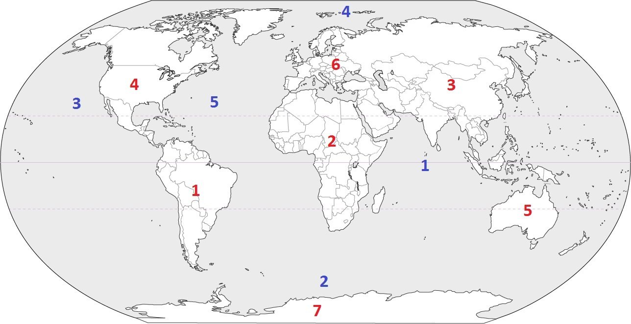
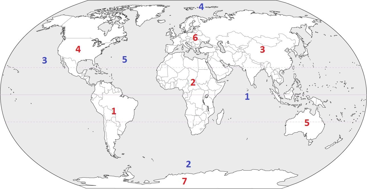
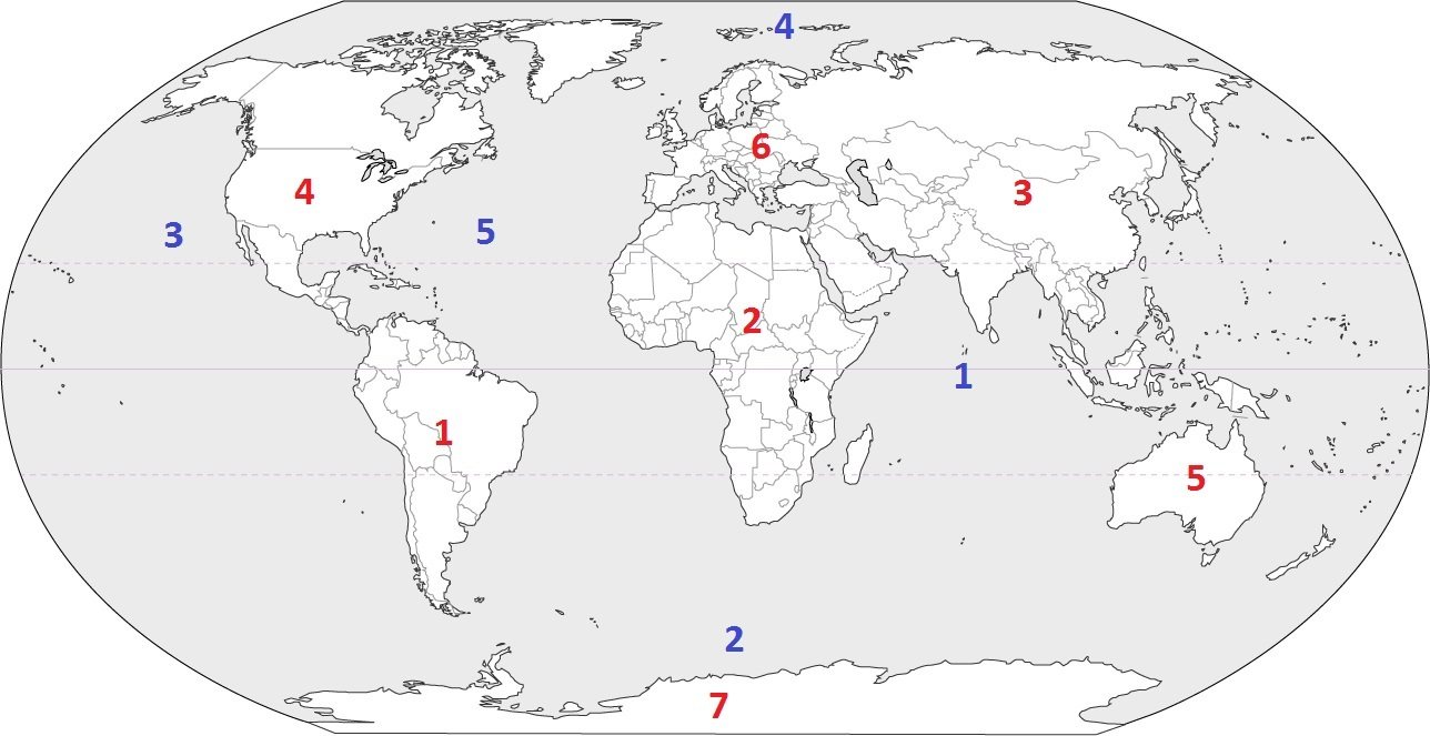
Identify the ocean at location #1.

a)

Southern Ocean

b)

Arctic Ocean

c)

Atlantic Ocean

d)

Indian Ocean

38.

Identify the ocean at location #5.

a)

Atlantic Ocean

b)

Southern Ocean

c)

Pacific Ocean

d)

Arctic Ocean

39.

Identify the ocean at location #3.

a)

Atlantic Ocean

b)

Arctic Ocean

c)

Pacific Ocean

d)

Indian Ocean

40.

Name the ocean that runs between North America and Europe and also South America and Africa.

a)

Arctic Ocean

b)

Atlantic Ocean

c)

Pacific Ocean

d)

Southern Ocean

e)

Indian Ocean

41.

Name the most northerly ocean in the world.

a)

Arctic Ocean

b)

Atlantic Ocean

c)

Pacific Ocean

d)

Southern Ocean

e)

Indian Ocean

42.

Which is the most populated continent with 60% of the total population of the Earth living here?

a)

Africa

b)

Asia

c)

Europe

d)

North America

43.

This continent was greatly devastated by intensive and unprecedented bushfires in early 2020.

a)

Antarctica

b)

Australia

c)

North America

d)

South America