Wayground logo

Free Printable Worksheets

Font size

S
M
L
XL
Worksheets

SS8G1 TEST Review

Total questions: 20

Worksheet time: 10mins

Name
Class
Date
1.

Georgia's four transportation systems improve both intrastate and interstate trade and ...

a)

account for over half of the Georgia's yearly budget

b)

generate electricity for major cities in Georgia

c)

create thousands of jobs for the Georgia's citizens.

d)

provide clean drinking water for rural Georgia.
2.
How does Georgia's climate help its economy?
a)
The mountains attract millions of tourists each year for their world famous snow skiing.
b)
Atlanta has grown into the premier city in the Southeast and offers a wide variety of jobs.
c)
Long growing seasons and adequate moisture in most years allow a wide variety of crops to be produced.
d)
Rivers and roadways provide much needed transportation routes for distribution of goods produced there.
3.
Which of Georgia's physical features can be classified as a wetland and, as such, has been designated a National Wildlife Refuge and a National Wilderness Area?
a)
Fall Line
b)
Okefenokee Swamp
c)
Cumberland Island
d)
Chattahoochee River
4.
Which of these BEST describes the location of Georgia?
a)
Middle West United States
b)
Northwestern United States
c)
Southwestern United States
d)
Southeastern United States
5.
What protects Georgia from damage by storms and hurricanes?
a)
the Atlantic Ocean
b)
the Savannah River
c)
the Barrier Islands
d)
the state of Florida
6.
Because of the climate in Georgia, early colonists found Georgia to be a good place for
a)
the king to reside.
b)
the first American colony.
c)
growing crops to send to England.
d)
hiring people to work in England.
7.
The state of Georgia is found in BOTH the
a)
Northern and Western hemispheres.
b)
Northern and Eastern hemispheres.
c)
Southern and Western hemispheres.
d)
Southern and Eastern hemispheres.
8.
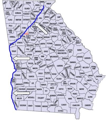
The blue line represents what Georgia river?
a)
Flint
b)
Savannah
c)
Ocmulgee
d)
Chattahoochee
9.
What is the name of the mountain range that is labeled with the red arrows?
a)
Black Hills
b)
Rocky Mountains
c)
Sierra Nevadas
d)
Appalachian Mountains
10.
Georgia's climate attracts businesses and industries because the state
a)
has a low tax rate.
b)
rarely experiences tornadoes.
c)
has an efficient highway system.
d)
has mild winters and adequate rainfall.
11.
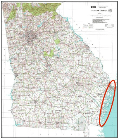
Georgia's "Barrier Islands" are circled on the map. Which of these offers the BEST explanation for this name?
a)
It attracts many tourists each year.
b)
It protects Georgia's fresh water supply.
c)
It helps protect mainland Georgia from storms & erosion.
d)
It prevents people from Florida from entering Georgia.
12.
(SS8G1b) The Ridge and Valley region in Georgia is best known for
a)
Peaches
b)
Carpet and textiles
c)
Peanuts
d)
Veggies
13.

(SS8G1) ~ Population heart, Industrial Heart (cars and planes built here),2nd largest physiographic region

a)

Coastal Plain

b)

Blue Ridge

c)

Ridge and Valley

d)

Piedmont

14.
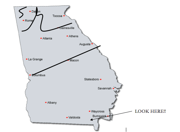
What physical feature is at LOOK HERE? 
a)
Fall Line
b)
Piedmont
c)
Okefenokee Swamp 
d)
Appalachian Mountains
15.

Today, access to water and water quality are important issues in Georgia because

a)

the state lacks environmental regulations that would prevent water pollution.

b)

continued population growth has increased demand for limited water resources.

c)

the fishing industry has long been among the most profitable enterprises in the state.

d)

limits on other forms of energy production have made the state reliant on hydropower.

16.

In recent decades, Georgia has been involved in a feud with neighboring states over use of two shared river basins, the Apalachicola Chattahoochee-Flint and the Alabama-CoosaTallapoosa. Why is this issue a significant economic concern for Georgia?

a)

The state's agricultural industry and large population require substantial amounts of water.

b)

The deepwater ports in the basins are vital to the flow of trade throughout the state.

c)

The economy of the state is dominated by the commercial fishing industry.

d)

The majority of the state's manufacturing facilities rely on hydropower for operation

17.

In which region of Georgia did one of the first gold rushes in the United States takes place?

a)

region I

b)

region II

c)

region III

d)

region Iv

18.

How did the impact of the Civil War on Georgia's waterways affect the state's economy?

a)

Competition over Georgia’s waterways hindered factories that relied on hydropower

b)

Competition over Georgia’s waterways opened new markets for Georgia’s businesses.

c)

The Union cleared the waterways for private use and improved irrigation and agricultural production.

d)

The Confederacy cleared the waterways for private use to power factories producing wartime supplies.

19.

Where is the state of Georgia located?

a)

in the Southern and Western Hemispheres

b)

in the Northern and Western Hemispheres

c)

. in the Southern and Eastern Hemispheres

d)

in the Northern and Eastern Hemispheres

20.

Based on your knowledge of Georgia, where are these cities located?

a)

the Piedmont region

b)

the Valley and Ridge region

c)

the Blue Ridge region

d)

the Coastal Plain region