
 Worksheets
Beginning of the Year Map Skills
Total questions: 16
Worksheet time: 12mins

What is the geographical feature labeled with a letter A?
Mississippi River
Rio Grande River
Great Lakes
James River

What is the geographical feature labeled with a C?
James River
Chesapeake Bay
Rio Grande River
Mississippi River

What is the name of the purple continent?
North America
South America
Africa
Europe

What is the name of the green continent?
South America
North America
Australia
Europe

What is the name of the brown continent?
Antarctica
Europe
Africa
South America
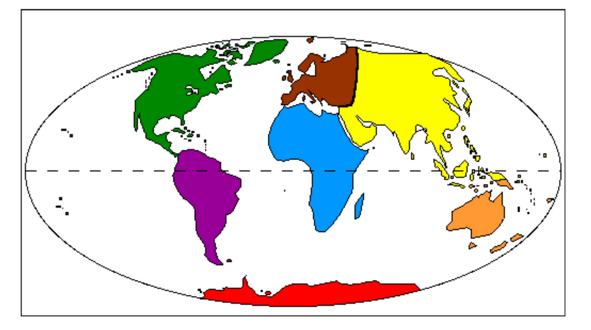
What is the name of the yellow continent?
Africa
Europe
Australia
Asia

What is the name of the blue continent?
Asia
Africa
Antarctica
Australia
How many continents and oceans are there in the world?
7 continents and 4 oceans
8 continents and 4 oceans
7 continents and 5 oceans
8 contents and 5 oceans


What are the lines that go from north to south called?
Longitude Lines
Latitude Lines
Prime Meridians
Equators

What are the lines that run from east to west called?
Longitude Lines
Equators
Prime Meridians
Latitude Lines

The symbols shown are examples of items that would be found on a ______________________ of a map.
Legend
Compass Rose
Scale
Border

What does the scale on a map show?
The conversion of distance or size to the size of the map.
How many people live in a country.
The difference between kilometers and millimeters.
The way to read a ruler.

What type of map is shown?
Population Map
Climate Map
Physical Map
Political Map

What type of map is shown?
Physical Map
Political Map
Climate Map
Population Map

What are the names of the three regions of Tennessee?
Western, Middle, Eastern
Memphis Delta, Middle Basin, Eastern Mountains
Northwestern, Southern, and Eastern
Delta, Plateau, Plains

