Wayground logo

Free Printable Worksheets

Font size

S
M
L
XL
Worksheets

SS Unit 1 Topic 1 Review

Total questions: 35

Worksheet time: 30mins

Name
Class
Date
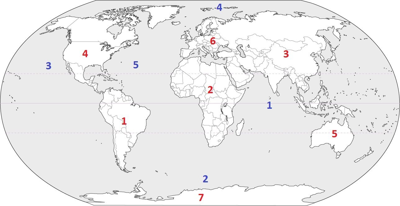
1.
What is the continent that is pink?
a)
North America
b)
South America
c)
Asia
d)
Australia
2.
What is the continent that is blue?
a)
Africa
b)
Australia
c)
Antarctica
d)
Asia
3.
What is the continent that is red?
a)
North America
b)
Europe
c)
Africa
d)
Australia
4.
What is the continent that is dark green?
a)
North America
b)
South America
c)
Europe
d)
Australia
5.
What is the continent that is yellow?
a)
Africa
b)
Australia
c)
Asia
d)
Antarctica
6.
What is the continent that is orange?
a)
Africa
b)
Australia
c)
Antarctica
d)
Asia
7.
What is the continent that is light green?
a)
North America
b)
South America
c)
Africa
d)
Australia
8.

What hemisphere is the United States in?

a)

Southern

b)

Up

c)

Northern

d)

Equador

9.
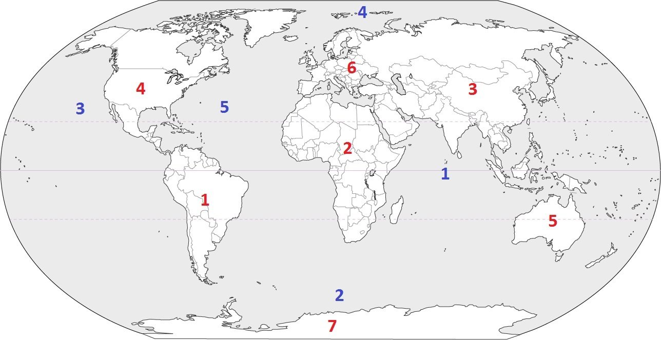
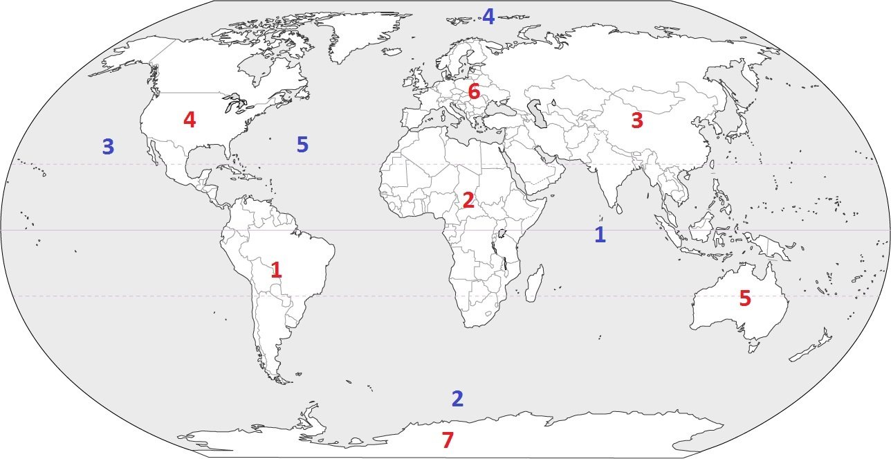
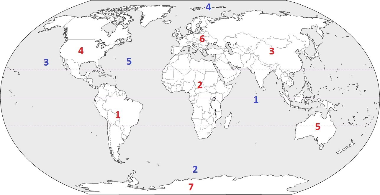
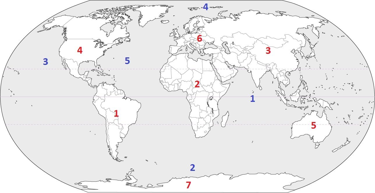
Identify the ocean at location #3
a)
Atlantic Ocean
b)
Arctic Ocean
c)
Pacific Ocean
d)
Indian Ocean
10.
Identify the ocean at location #5
a)
Atlantic Ocean
b)
Southern Ocean
c)
Pacific Ocean
d)
Arctic Ocean
11.
Identify the ocean at location #2
a)
Indian Ocean
b)
Pacific Ocean
c)
Southern Ocean
d)
Arctic Ocean
12.
Identify the ocean at location #1
a)
Southern Ocean
b)
Arctic Ocean
c)
Atlantic Ocean
d)
Indian Ocean
13.
Identify the ocean at location #4
a)
Indian Ocean
b)
Pacific Ocean
c)
Arctic Ocean
d)
Atlantic Ocean
14.

What separates the Northern and Southern hemispheres?

a)

Prime Meridian

b)

Line 180

c)

Equator

d)

Tropic of Capricorn

15.

What separates the Eastern and Western hemispheres?

a)

Prime Meridian

b)

Line 180

c)

Equator

d)

Tropic of Capricorn

16.
What is the approximate location of G?
a)
100oW, 40oN
b)
40oN, 100oW
c)
40oS, 100oW
d)
40oN, 100oE
17.

What direction does the red X represent?

a)

North

b)

South

c)

East

d)

West

18.

What direction does the red X represent?

a)

North

b)

South

c)

East

d)

West

19.

What direction does the red X represent?

a)

Northeast

b)

Northwest

c)

Southeast

d)

Southwest

20.
What is this?
a)
key
b)
title
c)
compass rose
d)
star
21.

What does the red line in the picture show?

a)

states

b)

Equator

c)

continents

d)

countries

22.

What is this?

a)

A beautiful picture

b)

A map key

c)

Fire, trees, dots, hills

23.

What is the name of the map feature that is circled in blue?

a)

scale

b)

key

c)

ocean

d)

title

24.

What is the purpose of a distance scale?

a)

to show the distance between places

b)

to show where the next lake is

c)

to tell you what the symbols on a map mean

d)

to help you find south

25.

What does the "N" on the compass rose stand for?

a)

North

b)

Napa

c)

Norway

d)

Nevada

26.
tells you the topic of a map, what the map is about
a)
Map Title 
b)
Map Key 
c)
Map Grid
d)
Compass Rose 
27.
shows what the symbols on the map stand for
a)
Map Title 
b)
Map Grid 
c)
Map Scale 
d)
Map Key
28.

Tells distance on a map in kilometers and miles

a)

key

b)

title

c)

compass rose

d)

scale

29.
What direction would you travel in to get from Perth to Sydney
a)
North
b)
East
c)
South 
d)
West
30.

Which imaginary line runs vertically (up and down) between the North Pole and South Pole?

a)

Equator

b)

Prime Meridian

c)

Arctic Circle

d)

Antarctic Circle

31.

The Prime Meridian separates Earth into which TWO hemispheres?

a)

Northern Hemisphere

b)

Southern Hemisphere

c)

Eastern Hemisphere

d)

Western Hemisphere

32.

The Equator separates Earth into which TWO hemispheres?

a)

Northern Hemisphere

b)

Southern Hemisphere

c)

Eastern Hemisphere

d)

Western Hemisphere

33.
Antarctica, Australia, and most of South America are in what hemisphere? 
a)
Northern 
b)
Southern 
c)
Western 
d)
Eastern
34.
Asia and Australia are in what hemisphere?
a)
Northern
b)
Southern
c)
Western
d)
Eastern
35.
North and South America are in what hemisphere?
a)
Northern
b)
Southern
c)
Western
d)
Eastern