wayground logo

Free Printable Worksheets

Font size

S
M
L
XL
Worksheets

Grade 8 Geography - The Globe

Total questions: 135

Worksheet time: 2hrs 22mins

Name
Class
Date
1.

Imaginary lines that are nothern and southern hemisphere of the geographical globe is...........

a)

Longitude

b)

Latitude

c)

Rotation

d)

Revolution

2.

__________ lines are also called parallels because they are equal distance apart everywhere on the globe and they never touch.

a)

Longitude

b)

Latitude

c)

Equators

d)

Meridians

3.

The lines of ____________ are imaginary lines that run north to south around the globe and are also known as meridians.

a)

longitude

b)

latitude

c)

equators

d)

circles

4.

The ___________ is a longitude line that runs from the north pole to the south pole and measures 0° longitude.

a)

Antemeridian

b)

Prime Meridian

c)

Tropic of Cancer

d)

Equator

5.

____________ marks the convergence of the east and west lines of longitude and measures 180°.

a)

Antemeridian

b)

Prime Meridian

c)

Tropic of Cancer

d)

Equator

6.

The International Date Line is also known as the ______________.

a)

Antemeridian

b)

Equator

c)

Line of Demarcation

d)

Tropic of Capricorn

7.

The _________ is line of latitude that circles the earth halfway between the north and south poles. It measures 0° latitude.

a)

Antemeridian

b)

Equator

c)

Line of Demarcation

d)

Tropic of Capricorn

8.

Tropic of ___________ and the Tropic of ___________ mark the farthest point north and south of the equator were the sun rays fall vertically.

a)

Cancer Capricorn

b)

Cancer Unicorn

c)

Cancer Capri

d)

Cancer Corner

9.

The ___________ circle is about 66° 33’ N.

a)

Antarctic

b)

Arctic

c)

Cancer

d)

Capricorn

10.

________________ is a term used for half the globe.

a)

Circle

b)

Hemisphere

c)

Meridian

d)

Parallel

11.

A ____________ is a way of showing the curved surface of the earth flat map.

a)

circle

b)

hemisphere

c)

globe

d)

projection

12.

Which one of these projections is not a real map projection.

a)

Azimuthal Projection

b)

Homolosine Projection

c)

Mercator Projection

d)

Meyers Projection

e)

Robinson Projection

13.
Zero degrees latitude is also called the _______.      
a)
Tropic of Capricorn
b)
Equator
c)
Prime Meridian 
d)
Tropic of Cancer
14.
North America is in the ___________________ Hemisphere.
a)
Parallel
b)
Southern
c)
Northern
d)
Eastern
15.
When measuring the lines of latitude, always begin with the ______, which represents 0
degrees.
a)
Prime Meridian
b)
Equator
c)
Longitude
d)
North Pole
16.
To locate exact places on the earth, one must look at
a)
the intersecting lines of latitude and longitude
b)
the lines of latitude only
c)
the lines of longitude only
d)
a neighboring area to describe the location
17.
When measuring the lines of longitude, always begin with the _______, which represents 0 degrees.
a)
South Pole
b)
Equator
c)
Prime Meridian
d)
Latitude
18.

3. Every 24 hours, Earth completes one...(Page 26)

a)

revolution.

b)

axis.

c)

tilt.

d)

rotation.

19.

What is absolute location?

a)

Where a place is compared to another place.

b)

The location of a star on a map.

c)

Where a place is as defined by latitude and longitude.

d)

The location of oceans and continents.

20.

What is the name of this line at 0 degrees latitude?

a)

Prime Meridian

b)

North Pole

c)

Equator

d)

South Pole

21.

What is the name of the line at 0 degrees longitude?

a)

Equator

b)

North Pole

c)

South Pole

d)

Prime Meridian

22.
These lines run North-South but measure in degrees East & West.
a)
Latitude
b)
Longitude
c)
Equator
d)
Prime Meridian
23.
These lines run East-West but measure in degrees North & South
a)
Latitude
b)
Longitude
c)
Equator
d)
Prime Meridian
24.
Which of the following divides the earth into the Northern and Southern Hemispheres?
a)
Prime Meridian
b)
International Date Lines
c)
Time Zones
d)
Equator
25.

What hemisphere is north america in?

a)

North East

b)

North West

c)

South West

d)

South East

26.

What ways do longitude and latitude run?

a)

East to west and north to south

b)

Northwest to southwest and northeast to southeast

27.

What hemisphere is North China in?

a)

Northern

b)

Southern

c)

Eastern

d)

Western

e)

Trick question: there is no North China

28.
Movement of the earth spinning on its axis
a)
Rotation
b)
Revolution
c)
Distortion
d)
Axis
29.

True or False: A globe is a 3D, spherical scale model of the Earth.

(a)  

30.

Which of these changes would likely occur if the rate of Earth's rotation on its axis increased?

a)

The length of the seasons would be shorter.

b)

The length of the seasons would be longer.

c)

The length of a day would be shorter.

d)

The length of a day would be longer.

31.

The model shows Earth in several positions relative to the sun.


In which position is it winter in North America?

a)

Position 1, because North America receives the most direct sun

b)

Position 2, because North America is tilted toward the sun

c)

Position 3, because North America is parallel to the sun

d)

Position 4, because North America is tilted away from the sun

32.

A student wants to use a spinning basketball to model the day-and-night cycle on Earth.


What should the student do in order to best model the cause of the day-and-night cycle?

a)

Spin the ball in different directions

b)

Tilt the ball while it is spinning

c)

Paint one half of the ball black and the other half white

d)

Shine a bright light on one side of the ball

33.

In the summer many people enjoy going to the beach. The photograph shows a beach in Argentina, which is located in the Southern Hemisphere.


Which diagram shows the position of Earth when it is summer in Argentina?

a)
b)
c)
d)
34.

A student draws the model shown.


Which of these best compares the conditions at Location X and Location Y?

a)

Is is day at Location X and night at Location Y.

b)

It is winter at Location X and summer at Location Y.

c)

There are more hours of daylight at Location X than at Location Y.

d)

The moon is brighter when viewed from Location X than when viewed from Location Y.

35.

Which of these locations on Earth experiences the least change in the number of daylight hours throughout the year?

a)

Equator

b)

North Pole

c)

Tropic of Cancer

d)

Tropic of Capricorn

36.

Earth would not have seasons if it --

a)

no longer tilted on its axis

b)

stopped rotating on its axis

c)

took an additional month to orbit the sun

d)

revolved around the sun in the opposite direction

37.

The diagram below shows four positions in Earth's orbit around the sun.


The Northern Hemisphere experiences the beginning of spring when Earth is in --

a)

Position 1

b)

Position 2

c)

Position 3

d)

Position 4

38.
The turning or spin of Earth on its axis.
a)
Revolution
b)
Rotation
c)
Rounding
d)
Rousting
39.
What is the result of the Earth’s rotation?
a)
Seasons
b)
Eclipses
c)
Moon Phases
d)
Day and Night
40.
What is meant by revolution of the Earth around the Sun?
a)
orbit of Earth
b)
turning of Earth
c)
change of magnetic poles
d)
answer not shown
41.
Earth rotates ______ time(s) and revolves ______ time(s) each year.
a)
23.5 / 90
b)
4 / 365
c)
365 / 1
d)
12 / 7
42.
In the diagram below, which letters represent rotation and revolution?
a)
A/B
b)
B/C
c)
C/A
d)
B/A
43.
How does the tilt of the Earth look as it rotates around the Sun?
a)
The tilt is always in the same direction
b)
The tilt is the same in spring/fall and different in summer/winter
c)
The tilt is variable and changes seasonally
d)
Answer not shown
44.
What is the tilt of the Earth on its axis?
a)
30 degrees
b)
24.5 degrees
c)
23.5 degrees
d)
22 degrees
45.
How does the tilt of the Earth‘s axis affect the number of hours of sunlight that are hitting the Earth?
a)
Sunlight hours are the same all year
b)
Sunlight hours are greater when tilted toward the Sun
c)
Sunlight hours are greater when tilted away from the Sun
d)
Sunlight hours are variable and unpredictable
46.
How does the tilt of the Earth and the Earth’s revolution around the Sun cause seasons?
a)
The tilt wobbles so different parts of Earth are pointed a the Sun at different times of the year
b)
The tilt is in the same direction so during the year-long revolution, sunlight strikes different regions of the Earth more directly
c)
The tilt does not change but the Earth gets closer to the Sun during summer and farther from the Sun during winter
d)
The shifting tilt combined with the Earth moving closer and farther from the Sun during rotation causes the seasons
47.
When it is summer in the Northern Hemisphere, it is _____ in the Southern Hemisphere.
a)
spring
b)
summer
c)
fall
d)
winter
48.
When it is summer in the United States, it is _____ in England.
a)
spring
b)
summer
c)
fall
d)
winter
49.
When the Sun is 90° over a Tropic line, it is a/an _____.
a)
Solstice
b)
Equinox
c)
Ellipse
d)
Eclipse
50.
When the Sun is 90°over the equator, it is a/an _____.
a)
ellipse
b)
eclipse
c)
equinox
d)
solstice
51.
On March 21, the Sun is 90° over the ___, it is a/an ___, and the first day of ___.
a)
Tropic of Cancer / Equinox / Summer
b)
Tropic of Capricorn / Solstice / Fall
c)
Equator / Solstice / Spring
d)
Equator / Equinox / Spring
52.
On June 21, the Sun is 90° over the ___, it is a/an ___, and the first day of ___.
a)
Tropic of Capricorn / Equinox / Summer
b)
Tropic of Cancer / Solstice / Summer
c)
Equator / Solstice / Spring
d)
Equator / Solstice / Fall
53.
On September 21, the Sun is 90° over the ___, it is a/an ___, and the first day of ___.
a)
Tropic of Capricorn / Equinox / Winter
b)
Tropic of Cancer / Solstice / Winter
c)
Equator / Equinox / Fall
d)
Equator / Solstice / Spring
54.
On December 21, the Sun is 90° over the ___, it is a/an ___, and the first day of ___.
a)
Tropic of Capricorn / Solstice / Winter
b)
Tropic of Cancer / Solstice / Summer
c)
Equator / Equinox / Spring
d)
Equator / Equinox / Fall
55.
Seasons in the Southern Hemisphere are _______ those in the Northern Hemisphere.
a)
the same
b)
similar
c)
opposite
d)
answer not shown
56.
In winter in the Northern Hemisphere, days are ____ and nights are ____.
a)
Longer / shorter
b)
Equal / equal
c)
Shorter / longer
d)
answer not shown
57.
Which of the following best explains why City 3 experiences the smallest change in day length between summer and winter out of the four cities shown in the diagram below? 
a)
Earth rotates on its axis once every 24 hours
b)
City 3 is located close to the equator
c)
Earth completes one revolution of the Sun every 365 days
d)
City 3 is closest to the Sun during the North Hemisphere’s winter
58.
This is the reason we experience day and night
a)
rotation
b)
revolution
59.
This, along with the tilt of the Earth, is the reason we experience different seasons
a)
rotation
b)
revolution
60.
Takes about 24 hours to complete one
a)
rotation
b)
revolution
61.
The Earth's _______ is an imaginary line that goes from the North Pole to the South Pole.
a)
vernal equinox
b)
axis
c)
solar eclipse
d)
solar flare
62.
Spinning of the Earth on its axis is called...
a)
rotation
b)
revolution
c)
orbit
d)
double axis
63.
The EARTH REVOLVES around the:
a)
Sun
b)
Moon
c)
The Earth doesn't revolve
d)
The sun rotates
64.
Day and night is caused by the _____________ of earth on its axis.
a)
revolution
b)
orbit
c)
rotation
d)
space
65.
Which season is taking place in the Northern Hemisphere in Position 3?
a)
Winter
b)
Spring
c)
Summer
d)
Fall
66.
The Earth's axis is tilted _____ degrees.
a)
23.5
b)
25.3
c)
30.2
d)
24
67.
What happens when the area in which you live tilts away from the sun?
a)
It is summer.
b)
It is spring.
c)
It is winter.
d)
It is fall.
68.
The term equinox means....
a)
equal amount of day light and equal amount of night
b)
Equal amount of winter and summer
c)
Equal amounts of hot dogs for everyone
d)
The longest day of the year
69.
What do June 21 and December 21 have in common?
a)
equinox dates
b)
the moon is full
c)
solstice dates
d)
the cold fronts blow in
70.
What is the longest day of the year?
a)
winter solstice
b)
summer solstice
c)
fall equinox
d)
spring equinox
71.
Why is the Equator warmest?
a)
Because it is closest to the sun.
b)
Because it receives the most direct sunlight
c)
Because no clouds form here.
d)
Because it is far from the sun
72.
Which season is taking place in the Southern Hemisphere in Position 1?
a)
Winter
b)
Spring
c)
Summer
d)
Fall
73.
Which season is taking place in the Northern Hemisphere in Position 1?
a)
Winter
b)
Spring
c)
Summer
d)
Fall
74.
Which season has the least amount of daylight in the Northern Hemisphere?
a)
Winter
b)
Spring
c)
Summer 
d)
Fall
75.
When the Northern Hemisphere leans toward the sun, the northern part gets -
a)
more sunlight
b)
less sunlight
c)
to be winter
d)
cooler
76.
When are the equinoxes?
a)
June & December
b)
July & January
c)
April & October
d)
March & September
77.
Approximately how long does it take for the Earth to revolve around the sun?
a)
24 hours
b)
1 month
c)
365 days
d)
365 years
78.
The diagram shows the Earth's movement around the Sun. What is this diagram demonstrating? 
a)
day and night
b)
seasons
79.
The diagram shows the Earth's movement around its' axis. What is this diagram demonstrating? 
a)
day and night
b)
seasons
80.
Which answer correctly explains the time of day it is in each region? 
a)
X is nighttime because it is facing towards the Sun. 
b)
X is daytime because it is facing towards the Sun. 
c)
Y is nighttime because it is facing towards the Sun. 
d)
Y is daytime because it is facing towards the Sun. 
81.
According to the diagram, the southern hemisphere is experiencing summer because
a)
The bottom of the axis is facing the sun receiving more rays of sunlight.
b)
The bottom axis is not facing the sun 
c)
The axis is not tilted
d)
The top of the axis is facing the sun receiving more rays of sunlight.
82.
What do you notice about the axis in the summer season.
a)
The top of the axis is pointing to the sun
b)
The top of the axis is pointing away from the sun
c)
The top of the axis is shrinking
d)
The bottom is the axis is pointing to the sun.
83.
What do you notice about the axis during the winter season?
a)
The top of the axis is pointing away from the sun
b)
The top of the axis is pointing toward the sun.
c)
The bottom of the axis is pointing away from the sun.
d)
There is no axis
84.

The model shows Earth in several positions relative to the sun.


In which position is it winter in North America?

a)

Position 1, because North America receives the most direct sun

b)

Position 2, because North America is tilted toward the sun

c)

Position 3, because North America is parallel to the sun

d)

Position 4, because North America is tilted away from the sun

85.

In the summer many people enjoy going to the beach. The photograph shows a beach in Argentina, which is located in the Southern Hemisphere.


Which diagram shows the position of Earth when it is summer in Argentina?

a)
b)
c)
d)
86.

The Seasons on earth are caused by:

a)

The tilt of Earth's axis

b)

The Earth getting closer and farther from the sun

c)

The rotation of the earth

d)

The moon

87.
Which of the following best describes the tilt of the earth when it is summer in the southern hemisphere?
a)
The northern hemisphere is tilted toward the sun
b)
The northern hemisphere is tilted away from the sun
c)
The norther hemisphere is tilted neither toward or away from the sun
d)
Why are you talking about the northern hemisphere when you asked about the southern hemisphere?
88.

Which of the following best describes equinoxes?

a)

The earth is tilted neither toward or away from the sun

b)

The norther hemisphere is tilted toward the sun

c)

The northern hemisphere is tilted away from the sun

d)

The southern hemisphere is tilted toward the sun

89.
What is the shape of the earth's orbit around the sun?
a)
Circular
b)
Elliptical (slightly oval)
c)
Square to rectangular
d)
Variable and changes with the seasons (no particular shape)
90.
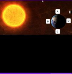
Which part of Earth is experiencing night?
a)
A
b)
B
c)
C
d)
D
91.

In the summer we get

a)

More hours of daylight than darkness

b)

Fewer hours of daylight than darkness

c)

The same number of daylight hours as darkness hours

d)

Extra moons

92.

In this image, what season is it in the northern hemisphere?

a)

Spring

b)

Summer

c)

Fall

d)

Winter

93.

When the Northern Hemisphere is tilting toward the sun, what is happening in the Southern Hemisphere?

a)

It is summer in the Southern Hemisphere

b)

The Southern Hemisphere is tilting toward the sun

c)

The Southern Hemisphere is tilting away from the sun

d)

They are both tilting the same direction

94.

In the Southern Hemisphere, the summer solstice is in

a)

March

b)

June

c)

September

d)

December

95.

The satellite image below shows a portion of the Namib Desert in Africa. This is an ancient, sandy desert with dunes that can be up to 305 m tall. The Namib Desert extends inland from the Atlantic Ocean between 80 km and 200 km and receives only 5 mm to 76 mm of rain each year.


A satellite picture of this same area taken weeks before shows that the shape and location of some sand dunes have changed. Which of these most likely caused the changes in the dunes?

a)

Ocean waves

b)

Flowing rivers

c)

Blowing wind

d)

Crustal uplift

96.
What would be the most likely way this coastline would change over time?
a)
A fire could destroy the vegetation
b)
The waves could erode the beach
c)
The beach would grow due to deposition
d)
The beach will disappear due to plate tectonics
97.
This landform was probably caused by - 
a)
high tides.
b)
wind.
c)
human activity.
d)
running water.
98.

This is a meteor crater. Which of the following is a prediction of how the crater will change over the next 1,000 years?

a)

The crater will become more shallow as the sides erode into the center.

b)

The crater will become deeper as animals make the crater home and burrow deep into the rock.

c)

The crater will not change over 1,000 years.

d)

The crater will fill in with lava.

99.

The satellite image below shows a portion of the Namib Desert in Africa. This is an ancient, sandy desert with dunes that can be up to 305 m tall. The Namib Desert extends inland from the Atlantic Ocean between 80 km and 200 km and receives only 5 mm to 76 mm of rain each year.


A satellite picture of this same area taken weeks before shows that the shape and location of some sand dunes have changed. Which of these most likely caused the changes in the dunes?

a)

Ocean waves

b)

Flowing rivers

c)

Blowing wind

d)

Crustal uplift

100.

Which point would best be described as the coastline?

a)

A

b)

B

c)

C

d)

D

101.

Which area would experience the most erosion from waves?

a)

A

b)

B

c)

C

d)

D

102.

What process created the main feature in this image

a)

Fluvian

b)

Aeolian

c)

Volcanic

d)

Impact

103.

What process created the main feature in this image

a)

Fluvian

b)

Aeolian

c)

Volcanic

d)

Impact

104.

What main geologic feature is shown in the image?

a)

Volcano

b)

Crater

c)

Caldera

d)

Lava

105.

What main geologic feature is shown in the image?

a)

Wind Streak

b)

Sand Dune

c)

Drainage Network

d)

Yardang

106.

What main geologic feature is shown in the image?

a)

Crater

b)

Delta

c)

Drainage Network

d)

Channel(River)

107.
As you travel from west to east, does it get later or earlier?
a)
Earlier
b)
Later
108.
The NFL game starts at 8 p.m. Eastern Standard Time. What time will it start in the Pacific Time Zone?
a)
10 p.m.
b)
4 p.m.
c)
5 p.m
d)
11 p.m.
109.
The new t.v. show is coming on at 7 p.m. Eastern Standard Time. What time will it be on at my friends house who lives in Central Standard Time?
a)
6 p.m.
b)
8 p.m.
c)
5 p.m.
d)
4 p.m.
110.
What is the time difference between Pacific time and Eastern time?
a)
Pacific time is 3 hours later
b)
Pacific time is 2 hours earlier
c)
Pacific time is 3 hours earlier
d)
Pacific time is 2 hours later
111.
California is in Pacific time zone and Boston is in Eastern time zone. If it is 10:00 A.M. in Boston, what time is it in California?
a)
1:00 P.M.
b)
7:00 A.M.
c)
12:00 P.M.
d)
11:00 A.M.
112.

When you head west across the International Date Line, it becomes the next day.

a)

True

b)

False

113.

P.M. stands for....

a)

past midnight

b)

post meridian

c)

post malone

d)

past morning

114.

Which location starts the day first?

a)

east

b)

west

115.

The prime meridian is drawn through a town called __________.

a)

Greenwich in London

b)

Jatujak in Thailand

116.

What is the meaning of GMT?

a)

Greedy Mean Time

b)

Greenwich Mean Time

117.

Anything to the _________ of Greenwich is ahead in time.

Anything to the _________ of Greenwich is behind in time

(a)  

118.

Time in each time zone is about how many hours difference?

a)

1 hour

b)

2 hours

119.

What is the time difference between London and Beijing?

a)

6 hours

b)

7 hours

120.

What is the time difference between Tokyo and Bangkok?

a)

2 hours

b)

4 hours

121.

What time zone is Melbourne in?

a)

Central Standard Time

b)

Western Standard Time

c)

Eastern Standard Time

d)

New Zealand

122.

What does it mean by 'Daylight Saving Time'?

a)

Clocks are put backwards 1 hour

b)

Clocks are put forward 1 hour

c)

Clocks are put backwards 2 hours

d)

Clocks are put forward half an hour

123.

If it was 6pm in Perth, what time would it be in Melbourne?

a)

7pm

b)

7:30am

c)

4pm

d)

8pm

124.

Why aren't time zone boundaries completely straight?

a)

to keep the same country in in the same time zone

b)

to confuse people

c)

for train schedules

d)

because of landforms

125.

When considering time zones, true or false, west is less and east increase?

a)

True

b)

False

126.

If it is January 20, 8:00 pm in New York City, what day and time is it in London

a)

January 20, 11:00 pm

b)

January 21, 1:00 am

c)

January 21, 2:00 am

d)

January 21, 3:00 am

127.

Why is it daytime in the UK when it is night-time in Australia?

a)

On opposite sides of the planet

b)

They have different seasons

c)

Distance from the moon

128.

London is six hours ahead of Mexico. When it’s 3.00 pm in London, what time is it in Mexico?

a)

12:00pm

b)

9:00pm

c)

12:00am

d)

9:00am

129.

London is six hours ahead of Mexico. When it’s 3.00 pm in London, what time is it in Mexico?

a)

12:00pm

b)

9:00pm

c)

12:00am

d)

9:00am

130.

When you are traveling East, do you add or subtract one hour for each time zone through which you travel?

a)

Add

b)

Subtract

131.

When you are traveling East, do you add or subtract one hour for each time zone through which you travel?

a)

Add

b)

Subtract

132.

Why Greenwich was chosen as the prime meridian?

a)

The fact that the USA had already chosen Greenwich as the basis for its own national time zone system.

b)

72% of the world's commerce depended on sea-charts which used Greenwich as the Prime Meridian.

c)

Greenwich had won the prize of Longitude 0º by a vote of 22 to 1 against (San Domingo), with 2 abstentions (France and Brazil).

d)

All of the above

133.

Name the countries that are +3 hours from GMT.

a)

Madagascar

b)

Iraq

c)

Yemen

d)

India

134.

If it is 8:00 am in the Philippines, what time is it in Prime Meridian and Brazil?

a)

Prime Meridian - 1:00am

Brazil - 9:00pm

b)

Prime Meridian - 12:00 midnight

Brazil - 8:00pm

c)

Prime Meridian - 1:00am

Brazil - 10:00pm

d)

Prime Meridian - 12:00midnight

Brazil - 9:00pm

135.

If it is 3:00 P.M. in Manila, what time is it in Taiwan, Singapore and Beijing?

a)

1:00 P.M.

b)

2:00 P.M.

c)

3:00 P.M.

d)

4:00 P.M.