wayground logo

Free Printable Worksheets

Font size

S
M
L
XL
Worksheets

Map Skills

Total questions: 87

Worksheet time: 2hrs 21mins
Name
Class
Date
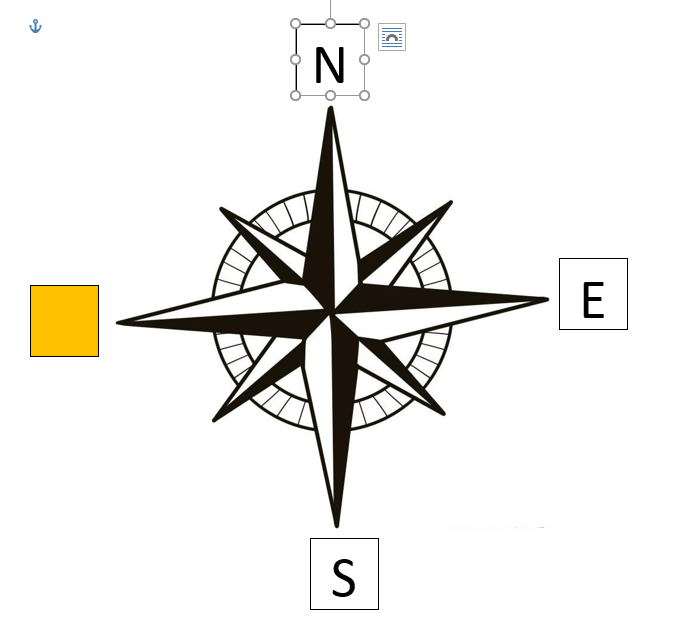
1.

Which direction is missing?

a)

North

b)

East

c)

Northwest

d)

South

e)

Northeast

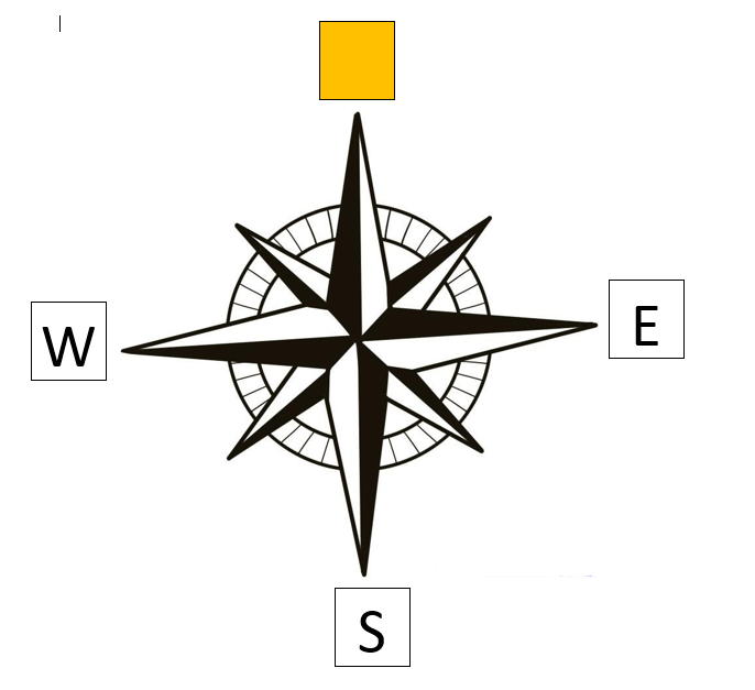
2.

Which direction is missing?

a)

North

b)

East

c)

Southeast

d)

South

e)

Northeast

3.

Which direction is missing?

a)

North

b)

East

c)

Southeast

d)

South

e)

Southwest

4.

Which direction is missing?

a)

West

b)

Northwest

c)

Southeast

d)

South

e)

Southwest

5.

Which direction is missing?

a)

North

b)

Northwest

c)

Southeast

d)

Northeast

e)

Southwest

6.

Which direction is missing?

a)

South

b)

Northwest

c)

Southeast

d)

Northeast

e)

Southwest

7.

Which direction is missing?

a)

West

b)

Northwest

c)

Southeast

d)

Northeast

e)

Southwest

8.

Which direction is missing?

a)

West

b)

Northwest

c)

North

d)

Northeast

e)

Southwest

9.

Which are the 4 Intermediate Directions

a)

North, East, South, West

b)

Northeast, Southeast, Southwest, Northwest

c)

North, Northeast, Northwest, West

10.

Which are the 4 Cardinal Directions

a)

North, East, South, West

b)

Northeast, Southeast, Southwest, Northwest

c)

North, Northeast, Northwest, West

11.
Which continent is located at letter "A"?
a)
Antarctica
b)
Africa
c)
Australia
d)
Asia
12.
Which continent is located at letter "B"?
a)
North America
b)
South America
c)
Central America
d)
African America
13.
Which continent is located at letter "C"?
a)
North America
b)
South America
c)
Central America
d)
African America
14.
Which continent is located at letter "D"?
a)
Asia
b)
Africa
c)
Europe
d)
Australia
15.
Which continent is located at letter "E"?
a)
Africa
b)
Asia
c)
Australia
d)
Antarctica
Antarctica
16.
Which continent is located at letter "F"?
a)
Asia
b)
Africa
c)
Australia
d)
Antarctica
17.
Which continent is located at letter "G"?
a)
Asia
b)
Africa
c)
Australia
d)
Antarctica
18.
How many continents are there?
a)
4
b)
1
c)
5
d)
7
19.
The equator divides what two hemispheres?
a)
East and West
b)
North and South 
20.
An imaginary line that divides the eastern and western hemispheres?
a)
equator
b)
longitude
c)
latitude
d)
prime meridian
21.
A set of degrees of latitude and longitude that help you locate a place on a map.
a)
coordinates
b)
positions
c)
hemispheres
d)
locations
22.
Which STATE is located at...
120°W, 45°N
a)
WA
b)
OR
c)
UT
d)
ND
23.
Which STATE is located at...
100°W, 48°N
a)
NM
b)
ND
c)
SD
d)
CO
24.

This type of map shows physical features of an area such as mountains, rivers and lakes.

a)

Political Map

b)

Physical Map

c)

Road Map

25.

These are imaginary lines running east and west and indicate if a place is in the northern or southern hemisphere.

a)

Longitude

b)

Latitude

26.

These are imaginary lines running north and south and indicate if a place is in the eastern or western hemisphere.

a)

Latitude

b)

Longitude

27.

This type of map shows state and national boundaries as well as large and small cities.

a)

Road Map

b)

Physical Map

c)

Political Map

28.
A _______________ is exactly half of the earth.
a)
Equator
b)
Hemisphere
c)
Tropic of Cancer
d)
Arctic Circle
29.
Which letter would you find at 15oS, 60oW?
a)
A
b)
C
c)
L
d)
H
30.
This line measures 0 degrees longitude:
a)
Equator
b)
International Date Line
c)
Meridians
d)
Prime Meridian
31.
The 0 degree line of latitude is the ___________.
a)
Equator
b)
Prime Meridian
c)
International Date Line
d)
Contour line
32.

A map that shows landforms.

a)

physical map

b)

road map

c)

political map

33.

A map that shows the population (# of people) of various places.

a)

topographic map

b)

population map

c)

road map

34.
Using lines of latitude and longitude to find an exact location is...
a)
Absolute Location
b)
Relative Location
c)
Prime Meridian
d)
Place
35.
Relative location is...
a)
how to get to a place
b)
finding the location of a place by describing its location from another place
c)
not a real thing
d)
exactly where something is located
36.
What is the measure of how far east or west a place is from the Prime Meridian called?
a)
Latitude
b)
Longitude
c)
Equator
37.
What is the measure of how far north or south a place is from the Equator called?
a)
Latitude
b)
Longitude
c)
Prime Meridian
38.
Latitude and Longitude are measured in ________.
a)
inches
b)
feet
c)
degrees
d)
grams
39.

How many hemispheres does Earth have?

a)

1

b)

2

c)

3

d)

4

40.

Twitter, Facebook and Instagram are used to share information.

a)

Location

b)

Place

c)

Region

d)

Movement

e)

Human-environment interaction

41.

Paris can be found at 48 degrees north and 2 degrees east.

a)

Location

b)

Place

c)

Region

d)

Movement

e)

Human-environment interaction

42.

Canada has 5 provinces and one of them is British Columbia.

a)

Location

b)

Place

c)

Region

d)

Movement

e)

Human-environment interaction

43.

In Colorado you can see the Rocky Mountains.

a)

Location

b)

Place

c)

Region

d)

Movement

e)

Human-environment interaction

44.

People in the south paint their houses light colors to reflect the heat.

a)

Location

b)

Place

c)

Region

d)

Movement

e)

Human-environment interaction

45.

Many people travel across the Brooklyn Bridge to get to Manhattan.

a)

Location

b)

Place

c)

Region

d)

Movement

e)

Human-environment interaction

46.

You can find it at the shop beside the lake.

a)

Absolute Location

b)

Relative Location

47.

Where one thing is located in relation to something else?

a)

relative location

b)

absolute location

48.

An exact location on a map.

a)

relative location

b)

absolute location

49.

Mexico is south of Texas.

a)

relative

b)

absolute

50.

76 degrees North, 42 degrees West

a)

absolute

b)

relative

51.

My friend's house is next door to mine. This is an example of what?

a)

absolute

b)

relative

52.

Which letter would you find at 60oN, 119oE?

a)

A

b)

C

c)

L

d)

H

53.

This line is located at 180o

a)

Prime Meridian

b)

Tropic of Cancer

c)

Arctic Circle

d)

International Date Line

54.

This map is an example of a . . .

a)

Population Map

b)

Thematic Map

c)

Climate Map

d)

Road Map

55.

Something you would find on a physical map is...

a)

a highway

b)

a lake

c)

a different subject

d)

a border between states or countries

56.

What type of map would you use to find your friend's house?

a)

Street Map

b)

Climate Map

c)

Physical Map

d)

Political Map

57.
Lines of longitude are what type of lines?
a)
vertical
b)
horizontal 
c)
parallel 
58.
Lines of Latitude are what type of lines?
a)
horizontal 
b)
vertical 
c)
intersecting
59.
What city is located at 32 degrees south and 150 degrees east?
a)
Shanghai
b)
Sydney
c)
Durban
d)
Calcutta 
60.
Which city is located at 38 degrees north and 120 degrees west?
a)
San Fransisco 
b)
New York
c)
New Orleans
d)
London
61.
North and South America are in what hemisphere?
a)
Northern
b)
Southern
c)
Western
d)
Eastern
62.
Europe, Asia and North America are in what hemisphere?
a)
Northern
b)
Southern
c)
Western
d)
Eastern
63.
Which continent is located completely north of the Equator and west of the Prime Meridian?
a)
Asia
b)
Europe
c)
North America 
d)
South America
64.
What ocean would you be in if you were at 30 degrees south and 150 degrees west?
a)
The Atlantic Ocean
b)
The Arctic Ocean
c)
The Pacific Ocean
d)
The Indian Ocean
65.
What city is located at 40 degrees North latitude and about 105 degrees West longitude?
a)
Colorado Springs
b)
Boulder
c)
Denver
d)
Durango
66.
Is the Tropic of Capricorn ABOVE the Equator or BELOW the Equator?
a)
Above
b)
Below
67.

Location D is located at which coordinates?

a)

30oN, 90oW

b)

90oN, 30oW

c)

10oN, 40oW

d)

30oN, 90oE

68.
The Tropic of Cancer and Tropic of Capricorn are what type of lines?
a)
Latitude lines
b)
International Date lines
c)
Longitude lines
d)
Meridian lines
69.
Is the Tropic of Cancer ABOVE the Equator or BELOW the Equator?
a)
Above
b)
Below
70.

What horizontal lines show the distance north or south of the equator?

a)

prime meridian

b)

tropics

c)

latitude

d)

longitude

71.

What vertical lines show distance east or west of the prime meridian?

a)

prime meridian

b)

longitude

c)

equator

d)

Tropic of Cancer

72.

What imaginary line marks the northern boundary of the tropics?

a)

Tropic of Capricorn

b)

Tropic of Cancer

c)

Tropic of Aquarius

d)

Tropic of Sagittarius

73.

What imaginary line marks the southern boundary of the tropics?

a)

Tropic of Capricorn

b)

Tropic of Cancer

c)

Tropic of Aquarius

d)

Tropic of Sagittarius

74.

What is located at 50ºN, 90ºW?

a)

Chicago

b)

Buenos Aires

c)

Paris

75.

What is located at 30ºS, 60º W?

a)

Buenos Aires

b)

Chicago

c)

Paris

76.

Which line of latitude is this?

a)

Tropic of Unicorn

b)

Tropic of Candycorn

c)

Tropic of Capricorn

d)

Tropic of Cancer

77.

Which line of latitude is this?

a)

Equator

b)

Tropic of Capricorn

c)

Tropic of Cancer

d)

Prime Meridian

78.

Which ocean is this?

a)

Arctic

b)

Pacific

c)

Indian

d)

Atlantic

79.

Which ocean is this?

a)

Arctic

b)

Pacific

c)

Indian

d)

Atlantic

80.

Which ocean is this?

a)

Arctic

b)

Pacific

c)

Indian

d)

Atlantic

81.

Which ocean is this?

a)

Arctic

b)

Pacific

c)

Indian

d)

Atlantic

82.

How many oceans are there in the world?

a)

7

b)

6

c)

5

d)

4

83.

Latitude 66°S is known as

a)

Antarctic circle

b)

Arctic circle

c)

Equator

d)

Prime meridian

84.

Latitude 23° N is called

a)

Tropic of Capricorn

b)

Arctic circle

c)

Tropic of Cancer

d)

Antarctic circle

85.

Which point is located at 45oN, 30oE?

a)

K

b)

D

c)

E

d)

G

86.

Latitude 23° S is called

a)

Tropic of Capricorn

b)

Arctic circle

c)

Tropic of Cancer

d)

Antarctic circle

87.

Latitude 66°N is known as

a)

Antarctic circle

b)

Arctic circle

c)

Equator

d)

Prime meridian