
 Worksheets
6th Grade Map Skills
Total questions: 48
Worksheet time: 27mins


What type of map is shown?
Physical Map
Political Map
Climate Map
Population Map

What is this called?
Compass Rose
Map Key
Map Scale
Compass
Which are the 4 Intermediate Directions
North, East, South, West
Northeast, Southeast, Southwest, Northwest
North, Northeast, Northwest, West
Which are the 4 Cardinal Directions
North, East, South, West
Northeast, Southeast, Southwest, Northwest
North, Northeast, Northwest, West

Which direction is missing?
West
Northwest
North
Northeast
Southwest

Which direction is missing?
West
Northwest
Southeast
Northeast
Southwest

Which direction is missing?
South
Northwest
Southeast
Northeast
Southwest

Which direction is missing?
North
Northwest
Southeast
Northeast
Southwest
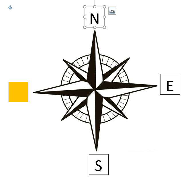
Which direction is missing?
West
Northwest
Southeast
South
Southwest

Which direction is missing?
North
East
Southeast
South
Southwest

Which direction is missing?
North
East
Southeast
South
Northeast
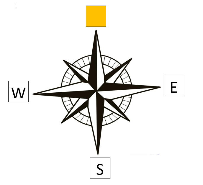
Which direction is missing?
North
East
Northwest
South
Northeast


Antarctica


a person who makes maps
Symbols
Compass rose
Legend/Key
Cartographer

The blue area on the map represents
Land Mass
Ocean
A Lake
Legend
What are examples of culture?
Language
Religion
Food
All of the above
What is an example of cultural diffusion?
Bjorg invites his friend Carlos over for a home-cooked Swedish meal.
Sandy explains the Hanukkah dreidel game, and then her class plays it.
The Spanish forced Christianity on the Native Americans when they conquered parts of South America.
When colonists fought the British during the American Revolution, they also resisted the British culture.
Who studies and produces maps?
Geographer
Bio-mappist
Cartographer
Physicist

Based on the graph, which country most likely had the highest GDP in US dollars?
United States
Mozambique
Russia
Canada
What category does the following fit in: South America, Africa, Asia, Australia, North America, Antarctica and Europe?
Countries
Cities
States
Continents
Language, food, clothing and religion are examples of...?
Set of Beliefs
Behavior
Culture
Art
What map would show the Earth's physical features?
Thematic map
Political map
Physical map
Global map

Which continent does most of the students want to visit?
Africa
Asia
Australia
Europe
When a person migrates from their home to another place, their culture is being spread through which of the following?
Pop culture
Cultural Isolation
Cultural Diffusion
Cultural Divergence
What is culture?
The system of government in a country.
A way of life shared by a group of people.
Only the religion of a community
Only the art and music of a group
Which could be part of the American culture?
Singing the national anthem at events?
Voting in presidential elections.
Celebrating the 4th of July.
All of the above.

According to the map, which direction is North America in?
Northwest
Southwest
Northeast
Southeast



imaginary lines on a map that run east and west (horizontal)
Latitude
Longitude

imaginary lines on a map that run up and down (vertical)
Latitude
Longitude

What is the map scale used to figure out?
the number of countries shown on the map
Which direction is north, south, east and west
The real distance between places on the map
What the map symbols mean

If you wanted to know the symbol for “river,” where on the map would you look?
The scale
The compass rose
The borders
The legend
A large land mass is a called a
country
continent
state
equator


