
 Worksheets
How to Read a Map
Total questions: 65
Worksheet time: 42mins

Examine the map. What does green stand for?
hills
plains
deserts
mountains

Examine the map. Which countries have high mountains?
Kuwait, Bahrain, Qatar
Kuwait, Bahrain, Yemen
Saudi Arabia, Yemen and Oman
Oman, UAE, and Bahrain

What symbol is located to the north of the park?
police station
barber shop
school
house

Examine the map. Which country has the most mountains?
Bahrain
Oman
UAE
Saudi Arabia

What does a Compass Rose show?
Where to find roses
Cardinal direction
Shaded arrows to look cool
How to find stars
All maps have a _____________. The __________________ tells you the subject of the map.
Compass Rose
Title
Scale Bar
Oral Traditions
Explains what the symbols on a map represent is a _____________________
History
Compass Rose
Title
Legend or Key
A _______________________ helps you find the actual distance between points shown on the map.
Title
Scale Bar
Compass Rose
Legend or Key
A ___________________ gives directions and find locations on a map
Compass Rose
Scale Bar
TItle
Legend or Key
_____________________ represents what a region looks like by showing its major physical features, such as hills, plains, elevation and relief.
Political Map
Thematic Map
Physical Map
Special Map
A _________________ shows political borders, such as continents, countries, and divisions within countries.
Physical Map
Political Map
Inset Map
Thematic Map

What type of map is this?
Physical Map
Creative Map
Political Map
Thematic Map

What type of map is this?
Political Map
Thematic Map
Inset Map
Physical Map
A compass rose tell us which ____________ places are in.
distance
symbol
direction

What is this map element called?
Legend
Star Guide
Cardinal Diamond
Compass Rose

The symbols shown are examples of items that would be found on a ______________________ of a map.
Legend
Compass Rose
Scale
Border

What type of map is shown?
Population Map
Climate Map
Physical Map
Political Map

What type of map is shown?
Physical Map
Political Map
Climate Map
Population Map

A map that shows mountains, rivers, deserts, etc is called a:
political map
physical maps
thematic maps
climatic maps
A map that shows political boundaries, cities, towns, etc., is called a:
scale
sketch
thematic maps
political maps

What is the title of this map?
KEY
Mediterranean Sea
The European Union, 2009
Atlantic Ocean

What is the westernmost country in the European Union
France
Greece
Portugal
United Kingdom

What body of water is bordered by both Spain and Greece
Atlantic Ocean
Mediterranean Sea
Black Sea

What is the title of this map?
Russia
China
Religions of Asia
Asia

What religion is shown by the color green?
Islam
Saudi Arabia
Asia
Christianity

What landforms takes up most of north western New England
Mountains
Peninsulas
Islands
Plains

What is the capital of Massachusetts
Boston
Hartford
Concord
Providence

What is this map trying to show?
Climate regions
population distribution
political parties
national borders

A ___________________ _______ shows how many people live in certain areas.
physical map
population map
climate map
resource map

A ___________________ _______ shows government features such as names and boundaries of countries, states, and cities.
physical map
population map
climate map
political map

What town has a population under 10,000?
Junction City
Third Fork
Friendly Corner

Using the compass rose, which directions are the mountains from the lake?
North
South
East
West

What are the majority resources are found along the eastern coast?
Iron Ore
Natural Gas
Coal
Asbestos
What resource would you say is the most abundant?
Iron Ore
Silver
Crude Oil
Asbestos
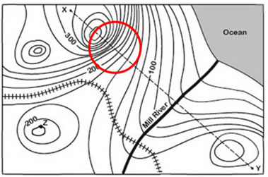
What is an example of a label you could find on a political map?
The name of the country
The symbol that shows which way north is
A line of latitude
A line of longitude

On the following map, what do the grey triangles represent?
Sources of fuel
Gold mines
Areas where precious gems can be found
Areas where nonmetals can be found

Which type of map would be good to use to find natural features and things like elevation?
Physical map
Political map
Special-purpose map

Which type of map might be used in finding countries?
Physical map
Political map
Special-purpose maps

This map is an example of a . . .
Population Map
Thematic Map
Climate Map
Road Map
What type of map would be helpful if you were looking for an area that had a lot of mining jobs?
Physical Map
Resource Map
Climate Map
Historical Map
A map showing boundaries of countries is what type of map?
Political
Physical
Population
Climate
What type of map would you use if you wanted to find the countries bordering Egypt?
Political
Physical
Road
Topographic

What type of map is this?
Physical
Political
Resource
Topographic

What type of map is this?
Political
Resource
Economic
Climate
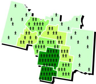
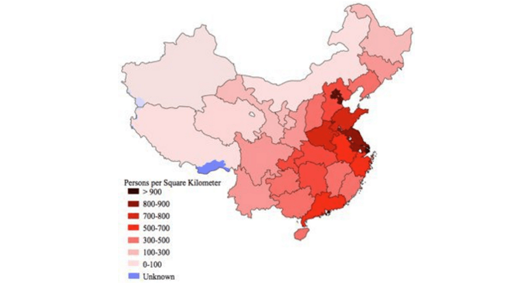

Which continent (not counting Antarctica) averages the fewest people per square mile?
North America
South America
Europe
Africa
Australia

In which part of Australia are most of the people located?
along the eastern and southeastern
coasts
in central Australia
along the northern coast
in western Australia

Which continent is more densely populated, Africa or Europe?
Africa
Europe
Asia
South America

Which region of the United States has fewer people per square mile, the Northeast or the Southwest?
Northeast
Southwest
North
West

The world’s two most-populous countries are on which continent?
North America
Europe
Asia
South America
Africa

In terms of this map, what do northern North
America and southern South America have in
common? (choose two answers)
Both are sparsely populated
Both are densely populated
Both are less than one person per square mile
Both have 11-25 people per square mile
Which environment is difficult to live in due to water scarcity?
Tropical rainforests
Mountain ranges
Deserts
Permanently frozen ground

Why would an area be sparsely populated?
lack of natural resources
land is covered with ice
land cannot be developed
all of the above

