
Font size
 Worksheets
Ancient Egypt Geography
Total questions: 12
Worksheet time: 6mins
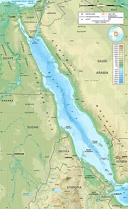
What is the sea to the EAST of Egypt shaped like rabbit ears or a slug? (Moses parted this sea).
Red Sea
Mediterranean Sea
Gulf of Mexico
Nile Sea

What river runs through Egypt?
Red River
Mediterranean River
Mississippi River
Nile River

Which kingdom is farther SOUTH?
Upper Egypt
Lower Egypt

Which body of water does the Nile River flow into?
Pacific Ocean
Indian Ocean
Mediterranean Sea
Red Sea
How did the Nile River benefit Egyptians? (select all that apply) Hint- only one doesn't apply
fresh drinking water
floods destroyed homes and crops
floods provided silt
papyrus grew near the river
a waterway for transportation

Name the geographical feature indicated by the top box. It is pointing at the large desert.
Nile River
Sahara
Gobi
Kalahari Desert


What is located in the circled area of the map?
Mediterranean Sea
Upper Egypt
Thebes
Nile Delta

Name the body of water circled in the picture.
Mediterranean Sea
Persian Gulf
Red Sea
Nile River

