wayground logo

Free Printable Worksheets

Font size

S
M
L
XL
Worksheets

Unit 1 Test Review

Total questions: 48

Worksheet time: 32mins

Name
Class
Date
1.
What does relative location tell you?
a)
a place's exact position on Earth
b)
a place's position in relation to other people and places
c)
how a place is similar to other places
d)
why people moved to a certain place
2.
Which of the following is a human characteristic of a place?
a)
climate
b)
language
c)
landforms
d)
vegetation
3.
Which theme of geography studies how and why places are similar to other places?
a)
human-environment interaction
b)
location
c)
place
d)
region
4.
Latitude and longitude
a)
human-environment interaction
b)
location
c)
place
d)
region
5.
How do people, goods, and ideas get around?
a)
human-environment interaction
b)
location
c)
movement
d)
region
6.
Which of the following could define physical region?
a)
a language
b)
a mountain range
c)
a religion
d)
political borders
7.
How do humans and the environment work together?
a)
human-environment interaction
b)
movement
c)
location
d)
place
8.

Geography is...

a)

The study of Earth and how we, the people who live there, interact with it.

b)

The study of Earth and its atmosphere.

c)

The study of rocks, minerals, and all physical attributes of Earth

9.

Equator is ...

a)

An imaginary line going across the center of Earth that separates the eastern and western hemisphere.

b)

A region created when the Earth is divided in half.

c)

An imaginary line going across the center of Earth that separates the north and south hemisphere.

10.

Prime Meridian is ...

a)

An imaginary line going across the center of the earth that separates the eastern and western hemispheres.

b)

An imaginary line going across the center of the earth that separates the north and south hemispheres.

c)

An absolute location on the map.

11.
Location is ...
a)
The way people, goods and ideas travel from place to place.
b)
Areas of the world that have common physical, human or cultural characteristics.
c)
Where a place is on Earth.
12.

A map showing boundaries of countries is what type of map?

a)

Political

b)

Physical

c)

Population

d)

Climate

13.
What type of map would be most helpful if you were looking for a tall mountain range to go skiing?
a)
Population Map
b)
Political Map
c)
Thematic Map
d)
Physical Map
14.
A Compass Rose shows ___________ on most maps.
a)
Symbols
b)
Routes
c)
Directions
d)
Climate
15.
What is weather in an area over a long period of time?
a)
Elevation
b)
Climate
c)
Title
d)
Scales
16.
The information that explains what each symbol on a map stands for is the _______,
a)
Inset Map
b)
Locator Map
c)
Compass Rose
d)
Key
17.
What type of map would you use to find your friend's house?
a)
Road Map
b)
Time Zone Map
c)
Physical Map
d)
Political Map
18.
What is the approximate location of letter B?
a)
80oN, 0o
b)
0o, 80oW
c)
80oS, 0o
d)
0o, 80oE
19.
Which of the following letter is at approximately 60 degrees S, 40 degrees W? 
a)
A
b)
D
c)
E
d)
H
20.
a)
The map shows lines of longitude.
b)
The map shows lines of latitude.
21.
a)
The map show the lines of longitude.
b)
The map shows the lines of latitude.
22.
You can use a scale on a map to:
a)
Find out how much the map weighs
b)
Determine the distance from one point to another
c)
Understand the meaning of the map's symbols
d)
Dance the night away
23.

Our Earth can be divided in half, either north and south or west and east. These halves are called ______________________.

a)

Pie

b)

Chunks

c)

Hemispheres

d)

Grids

24.
Earth is divided into seven landmasses known as ______________________.
a)
Hemispheres
b)
Countries
c)
Continents
d)
Sandboxes
25.

Name the red continent!

a)

North America

b)

Africa

26.

Name the green continent!

a)

South America

b)

Europe

27.

Name the yellow continent!

a)

Antarctica

b)

Europe

28.

Name the blue continent!

a)

Asia

b)

North America

29.

The brown continent is ________.

a)

North America

b)

Africa

30.

the purple continent is ________.

a)

Antarctica

b)

Australia

31.

The largest ocean is ______.

a)

Arctic

b)

Pacific

32.

Which ocean is the Southern Ocean?

a)

E

b)

G

c)

F

d)

B

33.

Which ocean is the Indian Ocean?

a)

E

b)

G

c)

F

d)

B

34.
In which region was this picture most likely taken?
a)
Outer Coastal Plain
b)
Piedmont
c)
Sand Hills
d)
Coastal Zone
35.
Which area of SC is known for sandy, dry soil, hot summers, cold winters, and the state's capital Columbia?
a)
Up Country
b)
Midlands
c)
Low Country
36.

How many oceans are there?

a)

3

b)

4

c)

5

d)

6

37.

Geographic Information System (GIS) –

a)

study of the earth's people

b)

database of geographic information used to create maps allowing for geographic analysis

c)

conditions that impact environment

d)

system that uses satellite data to pinpoint exact locations

38.

The person who makes map is called

a)

Cartographer

b)

Surveyor

39.

Which of the following describes a Climate map?

a)

Shows boundaries of countries and states

b)

Shows typical weather conditions

c)

Focuses on a specific topic, like population or languages

d)

Shows mountains, deserts, rivers, and lakes

e)

Shows natural resources and industries
40.

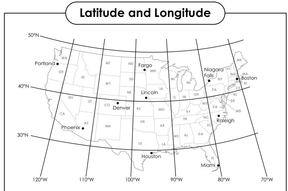
What is the Absolute Location of Houston?

a)

29°N, 95°W

b)

95°W, 29°N

c)

39°N, 95°W

d)

39°N, 85°W

41.

A map showing governmental boundaries of countries, states, and counties, the location of major cities.

a)

Political

b)

Physical

c)

Population

d)

Elevation

42.

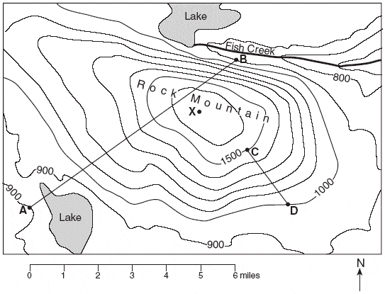
This map is an example of a . . .

a)

Topographic Map

b)

Political Map

c)

Survey Map

d)

Climate Map

43.

What's the purpose of a map?

a)

Decor a room

b)

Help you lose things

c)

Help you see things

d)

Help you find places

44.
The purpose of a map legend (or key) is:
a)
To explain the history of the map 
b)
To figure out the distance from one place to another
c)
To identify the meaning of symbols on the map
d)
To shampoo your hair, rinse, and repeat
45.
You can use a scale on a map to:
a)
Find out how much the map weighs
b)
Determine the distance from one point to another
c)
Understand the meaning of the map's symbols
d)
Dance the night away
46.
The title of a map tells us:
a)
What the map is about (the topic of the map)
b)
The distance the map covers
c)
The name of the cartogtrpaher
d)
That Mr. Scully is the bomb-diggity
47.
Lines that run north and south and measure distances in degrees from the Prime Meridian are called lines of ________________.
a)
Longitude
b)
Latitude
c)
Meridian
d)
Scale
48.
Earth is divided into seven landmasses known as ______________________.
a)
Hemispheres
b)
Countries
c)
Continents
d)
Sandboxes