
 Worksheets
Retake Quiz Plate Tectonics & Topographic Maps
Total questions: 23
Worksheet time: 46mins

Which direction is the stream flowing?
north
south
west
east
It is steep on a topographic map where __________.
lines are closest together
contours bend
lines are far apart

Which is steeper?


What do contour lines that are farther apart represent?
gentle slope
steep area

What direction is the river flowing?
Northeast
Southeast
Northwest
Southwest

what is the contour interval for this map?
50
10
100
200
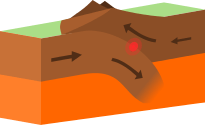

Oceanic Trenches are formed by _______ plate boundaries
Convergent
Transform
Plate
Divergent
Island arcs can from from magma which is pushed up at a __________ plate boundary.
Divergent
Convergent
Transform
The Great Rift Valley in Africa and the Mid-Ocean Ridge were all created by this boundary.
Divergent
Convergent
Reform
Transform

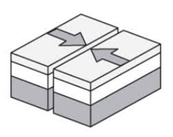
A mid-ocean RIDGE is located at the boundary of two tectonic plates. Which diagram correctly models the relative plate motion on each side of a mid ocean ridge?


Rift valleys can form when fractures in Earth's crust widen. The valley walls slowly move at a rate of only a few millimeters a year. Which of these best describes the type of tectonic activity that forms rift valleys?
Rift valleys form where a continental plate moves under an oceanic plate
Rift valleys form where a plate slides horizontally past another plate
Rift valleys form where two plates move away from each other.
Rift valleys form where an oceanic plate moves under another oceanic plate.

The San Andreas fault is a transform fault. The map below shows a student's approximation of where the fault line crosses through the United States. Students were asked to make maps predicting which way land would most likely move over thousands of years.


The model below shows two continental plates. The folded mountains in this model form at which type of plate boundary?
Transform boundary
Divergent boundary
Subduction boundary
Convergent boundary



