wayground logo

Free Printable Worksheets

Font size

S
M
L
XL
Worksheets

maps

Total questions: 141

Worksheet time: 2hrs 3mins

Name
Class
Date
1.
How many types of maps did we seein class?
a)
1
b)
5
c)
7
d)
9
2.
How many types of maps did we seein class?
a)
1
b)
5
c)
7
d)
9
3.
Which map shows the mountains and lakes on it?
a)
Vegetation map
b)
Contour map
c)
Physical map
d)
Historical map
4.
Which maps divides boundaries or borders, and shows roads?
a)
Political map
b)
Physical map
c)
Vegetation map
d)
Historical map
5.

What's the purpose of a map?

a)

Decor a room

b)

Help you lose things

c)

Help you see things

d)

Help you find places

6.
Which is a good example to use a map?
a)
When you're at 7-eleven and need to find chips.
b)
When you're looking for your lost notebook.
c)
When you want to find a ride at Six Flags.
d)
When you're looking for a friend.
7.
How many parts of a map did we see?
a)
7
b)
1
c)
9
d)
5
8.
Which part of a map helps you find the cardinal point of a place.
a)
scale bar
b)
compass rose
c)
key
d)
title
9.
Which part of a map is represented by a star? 
a)
capital
b)
city
c)
boundary line
d)
compass rose
10.
What is a scale bar for?
a)
to know the cardinal points
b)
to know the symbology of a map
c)
to know distances in a map
d)
to know the political divisions
11.
Which part of a map lets you know the symbology in it?
a)
compass rose
b)
capital
c)
scale bar
d)
key
12.

A drawing of the earth's surface on a flat surface according to scale

a)

sketch

b)

plan

c)

map

13.

A scale is necessary

a)

for a map

b)

for a sketch

c)

for symbols

14.

When large areas like continents are shown, we use

a)

large scale map

b)

small scale map

15.
What does this map symbol represent?
a)
Campsite
b)
Pub
c)
Caravan site
d)
Nature reserve
16.
What does this map symbol represent?
a)
Duck pond
b)
Nature reserve
c)
Nature park
d)
Natural heritage site
17.
What does this map symbol represent?
a)
Church with a tower
b)
Church with a spire
18.
What does this map symbol represent?
a)
Battlesite
b)
Sword fighting
c)
Castle
d)
History museum
19.
What does this map symbol represent?
a)
Church with a tower
b)
Church with a spire
20.
What does this map symbol represent?
a)
Campsite
b)
Caravan Site
c)
Pub
d)
Parking
21.
What does this map symbol represent?
a)
Quarry
b)
Cave
c)
Cliffs
d)
Landfill
22.
What does this map symbol represent?
a)
Sunshine
b)
Viewpoint
c)
Cave
d)
Train station
23.
What does this map symbol represent?
a)
Campsite
b)
Caravan Site
c)
Public Toilet
d)
Picnic Site
24.
Which is the more detailed map, 1:25000 or 1:50000?
a)
1:25000
b)
1:50000
25.
Scale = 1:20. If a bed is 200cm in real life, how many cm is it on the plan?
a)
10cm
b)
20cm
c)
5cm
d)
1cm
26.
Scale = 1:10. If a chair is 40cm in real life, how many cm is it on the plan?
a)
1cm
b)
4cm
c)
10cm
d)
40cm
27.
Scale = 1:50. If a sofa is 250cm in real life, how many cm is it on the plan?
a)
3cm
b)
5cm
28.
How many degrees latitude is the equator?
a)
0
b)
10
c)
-10
d)
5
29.
What kind of map will show me the states in the United States?
a)
Physical
b)
Climate
c)
Economic/Product or Resource
d)
Political
30.

a map feature that explains the meaning of colors and symbols used on a map

a)

map conents

b)

map glossary

c)

Map key

d)

map index

31.
True or False: A physical map will show you the boundaries of all of the states in The United States.
a)
True
b)
False
32.
What are the features on a Political map?
a)
Political units, countries, states, and borders
b)
Road maps, highway maps, weather/climate maps, and historical maps
c)
Physical/natural features, mountains, rivers, and valleys
33.
A larger picture of a specific place on a map.
a)
globe
b)
city
c)
inset map
d)
political map
34.
North West, North East, South East, South West 
a)
Inset Map
b)
Intermediate Directions
c)
Cardinal Directions
35.
True or false: A political map will show the boundaries of each state.
a)
True
b)
False
36.
mapmaking; the writing involved in making maps or charts.
a)
photography
b)
biography
c)
cartography
d)
seismograph
37.

A pattern formed as the lines of latitude and longitude cross one another.

a)

Compass

b)

Map scale

c)

Legend/key

d)

Grid system

38.

What are the two types of maps?

a)

Topographic and Climate

b)

Physical and Political

c)

Road and Symbols

d)

Political and Weather

39.

Which one is not a basic component of a map?

a)

Title

b)

Compass

c)

Color Code

d)

Scale

40.

What type of map is this?

a)

climate map

b)

economic resource map

c)

physical map

d)

political map

e)

topographic map

41.

What type of map is this?

a)

climate map

b)

economic resource map

c)

physical map

d)

political map

e)

topographic map

42.

What type of map is this?

a)

climate map

b)

economic resource map

c)

physical map

d)

political map

e)

topographic map

43.

What type of map is this?

a)

climate map

b)

economic resource map

c)

physical map

d)

political map

e)

topographic map

44.

What type of map is this?

a)

climate map

b)

economic resource map

c)

physical map

d)

political map

e)

topographic map

45.

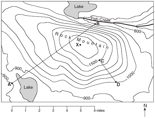
What type of map has contour lines to show changes in elevation?

a)

climate map

b)

economic resource map

c)

physical map

d)

political map

e)

topographic map

46.

What type of map shows borders of countries, states, and locations of cities

a)

climate map

b)

economic resource map

c)

physical map

d)

political map

e)

topographic map

47.

What type of map shows weather patterns or zones such as tropical wet?

a)

climate map

b)

economic resource map

c)

physical map

d)

political map

e)

topographic map

48.

What type of map shows geographic features such as bodies of water and mountains?

a)

climate map

b)

economic resource map

c)

physical map

d)

political map

e)

topographic map

49.

What type of map shows natural resources or manmade resources of an area?

a)

climate map

b)

economic resource map

c)

physical map

d)

political map

e)

topographic map

50.

This map is an example of a . . .

a)

Population Map

b)

Thematic Map

c)

Climate Map

d)

Road Map

51.

This map is an example of a . . .

a)

Topographic Map

b)

Political Map

c)

Survey Map

d)

Climate Map

52.

This map is an example of a . . .

a)

Physical Map

b)

Road Map

c)

Population Map

d)

Climate Map

53.

What type of map would be helpful if you were looking for an area that had a lot of mining jobs?

a)

Physical Map

b)

Resource Map

c)

Climate Map

d)

Historical Map

54.
What type of map would be most helpful if you wanted to find a good location for your new restaurant with plenty of customers?
a)
Political Map
b)
Population Map
c)
Historical Map
d)
Topographic Map
55.

A map showing mountains, rivers, oceans, valleys, and deserts is what type of map?

a)

Political

b)

Physical

c)

Population

d)

Climate

56.

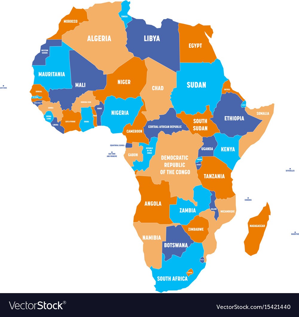
What type of map would you use if you wanted to find the countries bordering Egypt?

a)

Political

b)

Physical

c)

Road

d)

Topographic

57.

What map would you use to locate the largest body of fresh water in the world?

a)

Political

b)

Physical

c)

Resource

d)

Road

58.

What type of map is this?

a)

Physical

b)

Political

c)

Climate

d)

Population

59.

What type of map is this?

a)

Physical

b)

Political

c)

Economic Activity/Resource

d)

Climate

60.

What type of map is this?

a)

Physical

b)

Political

c)

Climate

d)

Economic Activity/Resource

61.

A type of map that shows the weather over a long period of time is a

a)

Population Map

b)

Political Map

c)

Climate Map

d)

Natural Resource Map

62.

What type of map shows transportation routes?

a)

climate

b)

topographic

c)

road

d)

population

63.

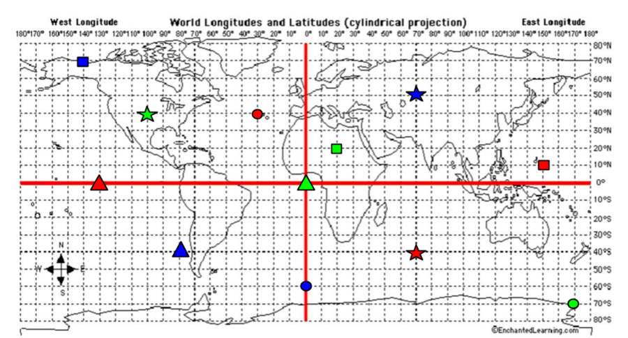
What are the coordinates for the RED star?

a)

40*S, 70*E

b)

40*N, 30*W

c)

0*, 130*W

d)

10*N, 150*E

64.

What are the coordinates for the BLUE Circle?

a)

40*S, 80*W

b)

60*S, 0*

c)

70*N, 140*W

d)

50*N, 70*E

65.

What are the coordinates for the BLUE Triangle?

a)

40*S, 80*W

b)

60*S, 0*

c)

70*N, 140*W

d)

50*N, 70*E

66.

What are the coordinates for the BLUE Star?

a)

40*S, 80*W

b)

60*S, 0*

c)

70*N, 140*W

d)

50*N, 70*E

67.
Which Hemisphere are both North America and South America found in?
a)
Western Hemisphere
b)
Eastern Hemisphere
c)
Southern Hemisphere
d)
Northern Hemisphere
68.
a)
The map shows lines of longitude.
b)
The map shows lines of latitude.
c)
poles
d)
global lines
69.
a)
The map show the lines of longitude.
b)
The map shows the lines of latitude.
c)
global lines
d)
poles
70.
When measuring the lines of latitude, always begin with the ______, which represents 0
degrees.
a)
Prime Meridian
b)
Equator
c)
Longitude
d)
North Pole
71.
When measuring the lines of longitude, always begin with the _______, which represents 0 degrees.
a)
South Pole
b)
Equator
c)
Prime Meridian
d)
Latitude
72.
What is the name of the line at zero degrees longitude?
a)
Equator
b)
Prime Meridian
c)
North Pole
d)
South Pole
73.
What is the name of the line at 0 degrees latitude?
a)
Prime Meridian
b)
Equator
c)
North Pole
d)
South Pole
74.
Latitude lines measure _________ and _______ of the Equator.
a)
east to west
b)
north to south
c)
north to west
d)
south to east
75.
Longitude lines measure the distance _________ and ___________ of the prime meridian.
a)
North and South
b)
East and West
76.
Which way does latitude go on a map?
a)
Up and down
b)
Side to side
c)
In a circle
d)
To infinity and beyond
77.
To locate a place on the earth, you need to look at...
a)
where the lines of latitude and longitude meet
b)
the lines of latitude only
c)
the lines of longitude only
d)
the compass rose
78.
Another name for lines of longitude is _______________.
a)
parallels
b)
meridians
c)
relief
d)
contour lines
79.
Latitude and Longitude are measured in______.
a)
kilometers
b)
degrees
c)
miles
d)
hours
80.
The Equator divides Earth into which two hemispheres
a)
Northern and Western
b)
Northern and Southern
c)
Eastern and Western
d)
Southern and Western
81.
The Prime Meridian divides the Earth into which two hemispheres
a)
Northern and Western
b)
Northern and Southern
c)
Eastern and Western
d)
Eastern and Northern
82.
Which letter would you find at 30oS, 30oE?
a)
A
b)
D
c)
K
d)
E
83.
Which letter would you find at 15oS, 60oW?
a)
A
b)
C
c)
L
d)
H
84.
North America is located in the: 
a)
Eastern & Southern Hemispheres
b)
Northern & Western Hemispheres
c)
Northern & Eastern Hemispheres
d)
Western & Southern Hemispheres
85.
BONUS:  Where does the Prime Meridian run through?
a)
Paris, France
b)
Ottawa, Canada
c)
Greenwich, England
d)
Austin, Texas
86.
BONUS: Africa is located in the:
a)
Eastern, Western, & Southern Hemispheres
b)
Northern, Eastern, & Western Hemispheres
c)
Northern, Eastern, & Southern Hemispheres
d)
Western, Northern, Southern, & Eastern Hemispheres
87.

What is the golden rule for finding a Grid Reference?

a)

Never eat soggy Weet-a-Bix.

b)

Along the corridor, then up the stairs.

c)

Along the pathway, and through the gate.

d)

Eastings before bee-stings.

88.
What is the 6-figure GR for the letter A?
a)
1334
b)
145345
c)
139344
d)
135345
89.

What would you find at 566169?

a)

Campsite

b)

Public House

c)

Farm

d)

Bridge

90.

Four-figure grid reference is found in the:

a)

top left corner of a square

b)

bottom left corner of a square

c)

top right corner of a square

d)

bottom right corner of a square

91.

Six-figured grid references should be divided into ___ parts.

a)

10

b)

5

c)

7

d)

12

92.

What is the grid reference of the snake?

a)

(B,9)

b)

(9,B)

c)

(C,7)

d)

(F,3)

93.

What is at F2?

a)

Mountains

b)

River

c)

Treasure

d)

Lake

94.

The horizontal lines in a grid are known as...

a)

Eastings

b)

Northings

95.

What is the interval of the above contour map?

a)

10 meters

b)

5 meters

c)

1 meter

d)

20 meters

96.

What is the grid reference for car park?

4 lines
97.

What are the reference numbers that appear first in a grid reference?

a)

Northings

b)

Eastlings

c)

Northlings

d)

Eastings

98.

Who does NOT use a grid reference while working?

a)

pilot

b)

driver

c)

cook

d)

travellers

99.

The EQUATOR is an imaginary line around the middle of the Earth?

a)

True

b)

False

100.

A drawing of the earth's surface on a flat surface according to scale

a)

sketch

b)

plan

c)

map

101.

Universal language of maps

a)

conventional symbols

b)

signs

c)

directions

102.

Some maps focus on specific information , they are

a)

political maps

b)

physical maps

c)

Thematic maps

d)

i

103.

The blue colour in a map shows

a)

mountains

b)

plains

c)

water

104.

The instrument in the picture

a)

clock

b)

barometer

c)

compass

105.

Identify the wrong statement

a)

globes are spherical in shape

b)

there are different types of globes

c)

globes helps us to identify location

106.

A scale is necessary

a)

for a map

b)

for a sketch

c)

for symbols

107.

When large areas like continents are shown, we use

a)

large scale map

b)

small scale map

108.

Cardinal points are

a)

intermediate directions

b)

sub directions

c)

major directions

109.
What is a mental map?
a)
A picture of a map in your head
b)
A map in an atlas
c)
A drawing of a map
d)
A map you designed 
110.
Why is everyone's mental maps different? 
a)
Not everyone sees the same thing
b)
Maps are different all over the world
c)
Better background knowledge
d)
This is false, everyone's is the same
111.
Lines on a map separate countries are called _______ and ________. 
a)
Borders and Boundaries
b)
Background and Borders
c)
Boundaries and Bubbles
d)
Borders and Beliefs
112.
Which of these ways can a country get its shape?
a)
Go to war with another country
b)
Ask another country for land
113.
Which of these ways can a country get its shape?
a)
Buy or sell land from another country
b)
Dig in the dirt around their land
114.
Which of these ways can a country get its shape?
a)
Rivers and Mountains
b)
Put up a fence
115.
What does visual association mean?
a)
A place that looks familiar
b)
A shape you have never seen. 
c)
A place you imagine
d)
A place near the equator
116.
One example of a visual association is:
a)
The angel in the Middle East
b)
The anchor in the Middle East
c)
The angel in North America
d)
The anchor in North America
117.
How can mapping data help us to analyze the data? 
a)
Shows us where the most and least expensive big macs are
b)
Show us where the most big macs are sold
c)
Show us how much big macs cost
d)
Show us where people eat McDonalds
118.

What kind of lines are these?

a)

contour lines

b)

horizontal lines

c)

diagonal lines

d)

cross contour lines

119.

What kind of lines are these?

a)

horizontal lines

b)

vertical lines

c)

diagonal lines

d)

curved lines

120.

______ is a type of drawing were you draw a continuous line while looking at your object, NOT your paper.

a)

implied contour

b)

outline

c)

upside down

d)

blind contour

121.

What type of line is this?

a)

dots

b)

wavy

c)

curly

d)

horizontal

122.

What type of line is in this picture?

a)

cross hatching

b)

spiral

c)

dots

d)

diagonal

123.

What kind of line is in the picture?

a)

horizontal

b)

vertical

c)

spiral

d)

dots

124.

Cross contour lines are both horizontal and vertical.

a)

True

b)

False

125.

A contour line defines the outline of a form, as well as interior structure, without the use of shading.

a)

True

b)

False

126.
Contour lines?
a)
Yes
b)
No
127.

______ is a very rapid, generalized line that is searching in nature and establishes base size, placement and attitude of your subject matter.

a)

gesture line

b)

outline

c)

contour line

d)

straight line

128.
Is this a contour line drawing?
a)
Yes
b)
No
129.

Which of these are the main types Lines? ¿Cuáles de estos son los principales tipos de líneas?

a)
b)
c)
d)
e)
130.

Oceans cover about ______ of the surface of the earth.

a)

60%

b)

70%

c)

80%

d)

90%

131.

There are _____ oceans in the world

a)

4

b)

6

c)

5

d)

9

132.

The following are the oceans according to size

a)

Pacific, Atlantic, Indian, Arctic, Antarctic

b)

Pacific, Indian, Atlantic, Arctic, Antarctic

c)

Atlantic, Pacific, Indian, Antarctic, Arctic

d)

Pacific, Atlantic, Indian, Antarctic, Arctic

133.

Smaller bodies of salt water are called

a)

seas

b)

lakes

c)

oceans

d)

rivers

134.

The ______________ covers a third of the earth's surface.

a)

Indian Ocean

b)

Pacific Ocean

c)

Atlantic Ocean

d)

Arctic Ocean

135.

Underwater volcanoes with flat tops are known as

a)

shelf

b)

abyss

c)

guyots

d)

slope

136.

Seas, bays, channels and gulfs are other bodies of _____

a)

salt water

b)

fresh water

c)

swampy water

d)

loamy water

137.

Winds blowing across the surface of the oceans and seas cause them to move in ripples called ________

a)

tides

b)

waves

c)

current

d)

motion

138.

Whales, eels, dolphin and squid are examples of

a)

benthos

b)

nekton

c)

zooplankton

139.

Which continent is know as "New World"?

a)

Asia

b)

South America

c)

North America

d)

Europe

140.

Which contintent shares land masses with Asia

a)

Europe

b)

Australia

c)

South America

d)

Africa

141.

Which continent has the most countires

a)

Asia

b)

China

c)

Africa

d)

Europe