
 Worksheets
Map Skills TEST
Total questions: 32
Worksheet time: 57mins
Type of map for finding landforms and land elevation
weather map
political map
thematic map
physical map
What is the 0° line of longitude that runs through the center of the Earth?
Tropic of Capricorn
latitude
Equator
Prime Meridian

Which dot is at 30° S, 30° W?
A
B
C
D

Which dot is at 13° N, 85° E?
A
B
C
D

Imaginary lines around Earth that run east to west, parallel to the Equator
latitude
longitude
ladders
Prime Meridian

Look at your map. What does the number "10" represent?
North America
Antarctica
Europe
Indian Ocean

Look at your map. What does the number "2" represent?
Africa
South America
Ireland
Pacific Ocean

Look at your map. What does the number "11" represent?
South America
Antarctica
Arctic Ocean
Asia

Look at your map. What does the number "8" represent?
Indian Ocean
Pacific Ocean
Australia
Africa

Look at your map. What does the number "5" represent?
Atlantic Ocean
Pacific Ocean
Australia
Asia

Look at your map. What does the number "6" represent?
Australia
North America
Tom Brady
South America
How many continents are there?
50
7
5
11

Look at your map. What does the number "1" represent?
North America
Asia
Africa
Europe

Look at your map. What does the number "4" represent?
Arctic Ocean
Africa
Antarctica
Europe

Look at your map. What does the number "7" represent?
Equator
Antarctica
Indian Ocean
Madagascar

Look at your map. What does the number "9" represent?
Atlantic Ocean
Pacific Ocean
Southern Ocean
Indian Ocean

Look at your map. What does the number "3" represent?
Asia
Europe
Greenland
Africa


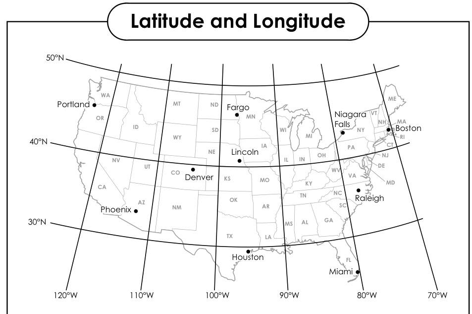
What is the Absolute Location of Denver?
west of St. Louis
39°N, 105°W
Southeast of Seattle
39°W, 105°N
75 Degrees South, 90 Degrees W is an example of which type of location?
Absolute
Relative

A (a) shows direction on a map.

Lines of (a) run from North to South, and are also called meridians.

Degrees of latitude and longitude help you determine (a) location of a place on Earth.

This type of map shows state or country borders as well as capital cities.
(a)
Used to measure distance on a map



