Wayground logo

Free Printable Worksheets

Font size

S
M
L
XL
Worksheets

Geography Bee

Total questions: 61

Worksheet time: 40mins

Name
Class
Date
1.
Zero degrees latitude is also called the _______.      
a)
Tropic of Capricorn
b)
Equator
c)
Prime Meridian 
d)
Tropic of Cancer
2.
What is this object known as?
a)
map symbol
b)
map key
c)
map scale
d)
compass rose
3.
Largest body of water on the planet?
a)
Atlantic Ocean
b)
Coral Sea
c)
Pacific Ocean
d)
Indian Ocean
4.

What is the largest country (by population)?

a)

Russia

b)

Brazil

c)

USA

d)

China

5.

What is the largest country (by land mass)?

a)

China

b)

Canada

c)

Madagascar

d)

Russia

6.

What is the largest Island

a)

Madagascar

b)

Iceland

c)

Greenland

d)

Great Britain

7.

What continent is Mount Everest in?

a)

Europe

b)

Asia

c)

North America

d)

Greenland

8.

What is the longest river in the world?

a)

Nile River

b)

Amazon River

c)

Thames River

d)

Yellow River

9.

How many continents are there on Earth?

a)

five

b)

seven

c)

three

d)

eight

10.

Which of the following is the ice-covered continent?

a)

North America

b)

Europe

c)

Oceania

d)

Antartica

11.
Which of the following is a mountain range in Europe?
a)
Alps
b)
Andes
c)
Rockies
d)
Tien Shan
12.
Which of the following is a country in South America?
a)
Mexico
b)
South Africa
c)
Brazil
d)
Cuba
13.
Which of the following is an ocean?
a)
 Michigan
b)
Mississippi
c)
Amazon
d)
Indian
14.
On which continent is Brazil located?
a)
South America
b)
North America
c)
Europe
d)
Africa
15.
What ocean is on Brazil's eastern coast?
a)
Indian Ocean
b)
Pacific Ocean
c)
Arctic Ocean
d)
Atlantic Ocean
16.

These maps show country and state boundaries, as well as the location of capitals, other major cities, and bodies of water.

a)

Political map

b)

Climate map

c)

Physical map

d)

Historical map

17.

Lines of longitude measure

a)

Distance in degrees east and west of the Prime Meridian

b)

Distance in degrees north and south of the Equator

c)

The distortion on a map

d)

The population density of an area

18.

What does GDP stand for?

a)

Gross National Product

b)

Grand Domestic Product

c)

Gross Domestic Product

d)

Giant Domestic Product

19.
What is not one of the 5 themes of Geography
a)
Interaction
b)
Location
c)
Climate
d)
movement
20.
The process in which countries are increasingly linked to each other through culture and trade is
a)
humanitarian aid
b)
culture
c)
globalization
d)
diffusion
21.
When countries depend on each other for resources, goods, or services, we call this
a)
globalization
b)
interdependence
c)
humanitarian aid
d)
popular diffusion
22.

Which river did Ancient Rome begin on?

a)

Euphrates River

b)

Tiber River

c)

Nile River

d)

Indus River

23.

Which mountains served as a natural border to the north of the Roman Republic?

a)

Alps

b)

Apennines

24.

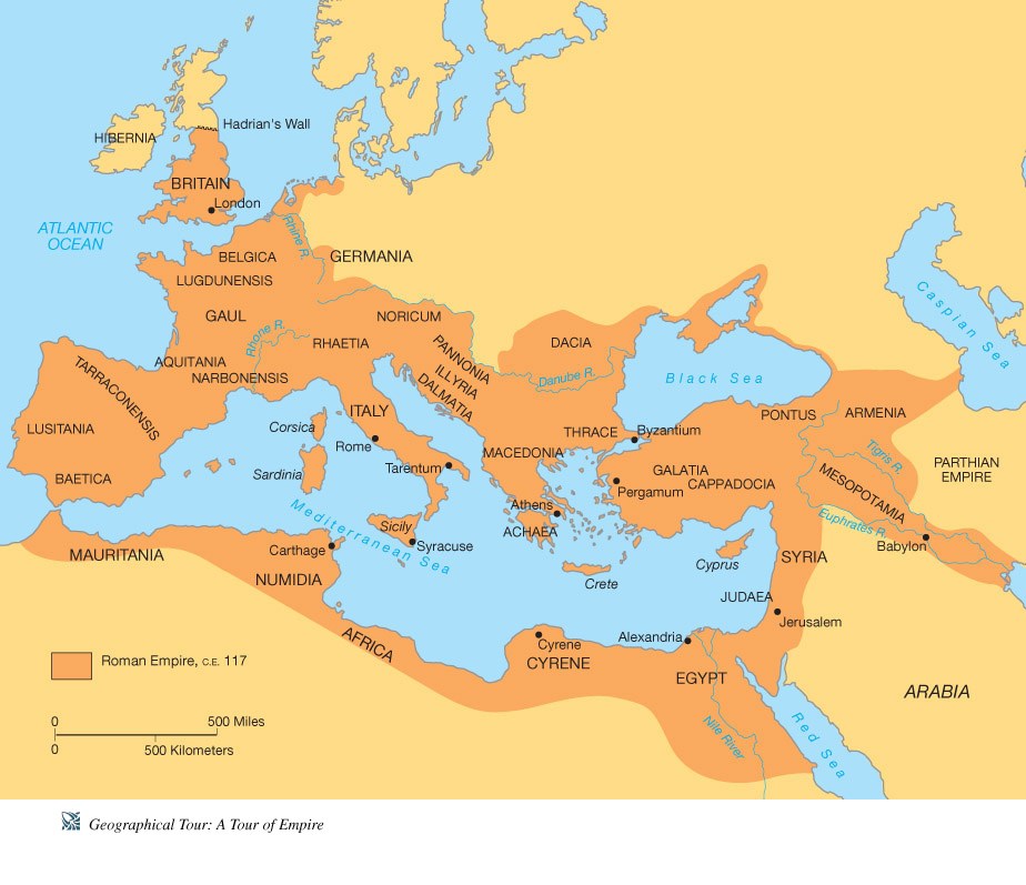
If you traveled from Rome to Carthage, which direction would you be going?

a)

Northeast

b)

Southwest

c)

Southeast

d)

Northwest

25.

What geographical term best describes Italy?

a)

subcontinent

b)

island

c)

peninsula

d)

mountain range

26.

Which body of water was surrounded by the Roman Empire?

a)

Pacific Ocean

b)

Atlantic Ocean

c)

Red Sea

d)

Mediterranean Sea

27.

What CONTINENT did the Roman Republic start on?

a)

Africa

b)

Asia

c)

Europe

d)

North America

28.
How did the Alps in the northern area of the Italian Peninsula aid Rome? 
a)
Kept rivers from flooding
b)
Provided protection from invasions
c)
Provided a mild climate
d)
Divided Rome into two distinctive city-states
29.
How did the Mediterranean Sea impact the development of Rome? 
a)
It allowed enemy forces to easily enter the city
b)
It limited the city's interaction with other people
c)
It provided numerous sea-borne trade routes
d)
It prevented Rome from expanding its empire
30.

A wall that is over 6,000 miles, which was built to keep the Mongolians in the north out of China.

a)

Plateau

b)

Mount Everest

c)

The Great Wall of China

d)

Atoll

31.

Rainy seasons in southern Asia that last for an extended period of time.

a)

Tsunami

b)

Monsoon

c)

Atoll

d)

Strait

32.

A giant wave usually caused by an earthquake beneath the ocean floor.

a)

Earthquake

b)

Monsoon

c)

Tsunami

d)

Tornado

33.

A tropical climate zone can be described as_________________________.

a)

cold, saturated climate zone near the equator

b)

warm, saturated climate zone near the equator

c)

hot, dry climate zone near the equator

d)

cold, dry climate zone near the equator

34.
Tokyo is in which country?
a)
Japan
b)
China
c)
India
d)
Sri Lanka
35.
Shanghai is a city in which country?
a)
Japan
b)
India
c)
China
d)
Pakistan
36.

The colliding of the Indian subcontinent with the Arabian and Asian tectonic plates formed what mountains?

a)

Mount Kilimanjaro and Mount Fuji

b)

Mount Olympus and Mount Pelion

c)

The Himalayas and the Pamir's Mountains

d)

The Denali Mountain and the Canadian Rockies

37.

The Tibet-Qinghai Plateau is the world's largest plateau.

a)

True

b)

False

38.

What river(s) begin in the Tibet-Qinghai Plateau?

a)

Indus

b)

Huang He

c)

Euphrates

d)

Chang Jiang

39.

The Chang Jiang Basins are wet coastal plains that provide fertile soil and ideal climate for...

a)

wheat

b)

rice

c)

coffee

d)

quinoa

40.

Which are the two major rivers that flow through China?

a)

The Yellow and Red Rivers

b)

The Yellow and Yangtze Rivers

c)

The Yangtze and East Rivers

d)

The Yingtze ane Yangtze Rivers

41.
Ancient China was surrounded by desert, mountains and ocean. What impact did these natural borders have on the culture? 
a)
They helped to integrate the cultures of other world civilizations.
b)
They caused China to constantly be at war with other world civilizations.
c)
They helped China to establish trade with other civilizations.
d)
They isolated the Chinese civilization allowing it to develop independently. 
42.

In China the Yellow River turns yellow because it flows through the _____________________.

a)

Tibet Plateau

b)

Loess Plateau

c)

Chinese Plain

d)

Yellow Sea

43.

Why is the Yellow River also known as China's Sorrow?

a)

Sometimes the river have the inability to produce silt for people to grow crops.

b)

The river frequently floods causing millions of deaths over the course of China's history.

c)

It is where people go when they are sad.

d)

China lost many battles against the Hun army along the Yellow River.

44.
What is the definition of levee
a)
A person who walks a lot 
b)
When you make a new invention for sale
c)
A cafe in north Lawrence 
d)
Large dirt mounts built to prevent over flowing of river
45.
Absolute and relative are two ways of describing the theme of...
a)
regions
b)
movement
c)
location
d)
human environment interaction
46.
Which is NOT an example of absolute location?
a)
"Katie's Restaurant is near the high school"
b)
35°N, 52°W
c)
6636 Northwest Road
d)
61°4′S, 21°15′E
47.

The human and physical features of a location are included in which theme?

a)

location

b)

region

c)

place

d)

movement

48.
Which theme includes how humans adapt, modify or depend on the environment?
a)
movement
b)
place
c)
region
d)
human environment interaction
49.
Which is an example of how humans modify the environment?
a)
we salt the roads when they get icy
b)
we wear warmer clothes in winter
c)
we wear sunscreen while outside in summer
d)
we use gasoline to power our vehicles
50.

Which is an example of how humans depend on the environment?

a)

dumping waste into our rivers

b)

cooling our buildings with air conditioning

c)

plowing snowy roads

d)

using land to grow crops (agriculture/farming)

51.

Which geography theme helps us understand how people, goods, information, and ideas move from one place to another?

a)

human environment interaction

b)

regions

c)

movement

d)

location

52.
The theme that helps us understand one area in terms of a unifying feature that it shares in common with another area is...
a)
place
b)
region
c)
location
d)
movement
53.

Why is the population of the Sahara so low?

a)

Too much water

b)

Too much oil

c)

Limited access to oil

d)

Limited access to water

54.

What landform has rolling grassland and scattered trees?

a)

Savanna

b)

Nile River

c)

Tropical Rain Forest

d)

Niger River

55.

An isthmus is:

a)

wide section of land

b)

an island

c)

narrow strip of land between two larger land areas surrounded by water

d)

a Mayan holiday

56.
The economy of Central America is mostly based on:
a)
industry
b)
fishing
c)
agriculture
d)
mining
57.

Central America has many descendants of what ancient civilization?

a)

French

b)

Inca

c)

Maya

d)

English

58.
Along which coast of Central America are volcanoes located?
a)
Pacific coast (west)
b)
Caribbean coast (east)
59.
The Caribbean is located to the _________ of Central America.
a)
north
b)
south
c)
east
d)
west
60.
Which country in the Greater Antilles is a territory of the United States?
a)
Cuba
b)
Jamaica
c)
Haiti
d)
Puerto Rico
61.
Which body of water is to the east of the Caribbean Islands
a)
Atlantic Ocean
b)
Caribbean Sea
c)
Gulf of Mexico
d)
Pacific Ocean