wayground logo

Free Printable Worksheets

Font size

S
M
L
XL
Worksheets

UIL Maps, Graphs & Charts 2021-2022

Total questions: 76

Worksheet time: 3hrs 46mins

Name
Class
Date
1.

Use the Index to answer the first 4 questions...

On what page would you find Garland, TX?

a)

85

b)

90

c)

95

d)

100

2.

On what page would you find Da Nang, Vietman?

a)

180

b)

181

c)

182

d)

183

3.

On what page would you find Nancy, France?

a)

156

b)

157

c)

158

d)

159

4.

On what page would you find the country of Samoa?

a)

185

b)

187

c)

189

d)

191

5.

Use Page 83 to answer the next 5 questions...


What two states have grapes as an Agricultural Product?

a)

California (CA)

b)

Oregon (OR)

c)

Washington (WA)

d)

Texas (TX)

6.

What is the main agricultural product in Georgia (GA)

a)

Cotton

b)

Corn

c)

Dairy

d)

Poultry

7.

What are three agricultural products of Texas?

a)

Almonds

b)

Beef

c)

Cotton

d)

Lettuce

e)

Poultry

8.

What percentage of Agricultural Exports is Fresh Fruit?

a)

2.5%

b)

2.9%

c)

4.0%

d)

5.5%

9.

AFRICA: The land cover of the Congo Basin is mostly of what

type?

a)

cropland

b)

desert

c)

tropical rain forest

d)

tundra

10.

AFRICA: How many miles is it from the capital of Uganda to

the capital of Somalia?

a)

about 500 miles

b)

about 700 miles

c)

about 900 miles

d)

about 1,100 miles

11.

AFRICA: What is the dominant land use in Angola?

a)

commercial farming

b)

forestry

c)

nomadic herding

d)

subsistence farming

12.

AFRICA: What capital is just north of the largest lake on the

continent?

a)

Cairo, Egypt

b)

Bamako, Mali

c)

Kampala, Uganda

d)

Cape Town, South Africa

13.

AFRICA: Which is the largest country by population?

a)

Ethiopia

b)

Nigeria

c)

South Africa

d)

Algeria

14.

The Great Dividing Range is located in what country?

a)

New Zealand

b)

Australia

c)

Korea

d)

China

15.

Guam is a territory of what country?

a)

China

b)

Russia

c)

United States

d)

Mexico

16.

The Christmas Island is a holding of what country?

a)

Australia

b)

India

c)

United States

d)

China

17.

Which continent has 36% of the wild cats?

a)

Asia

b)

Africa

c)

North America

d)

South America

18.
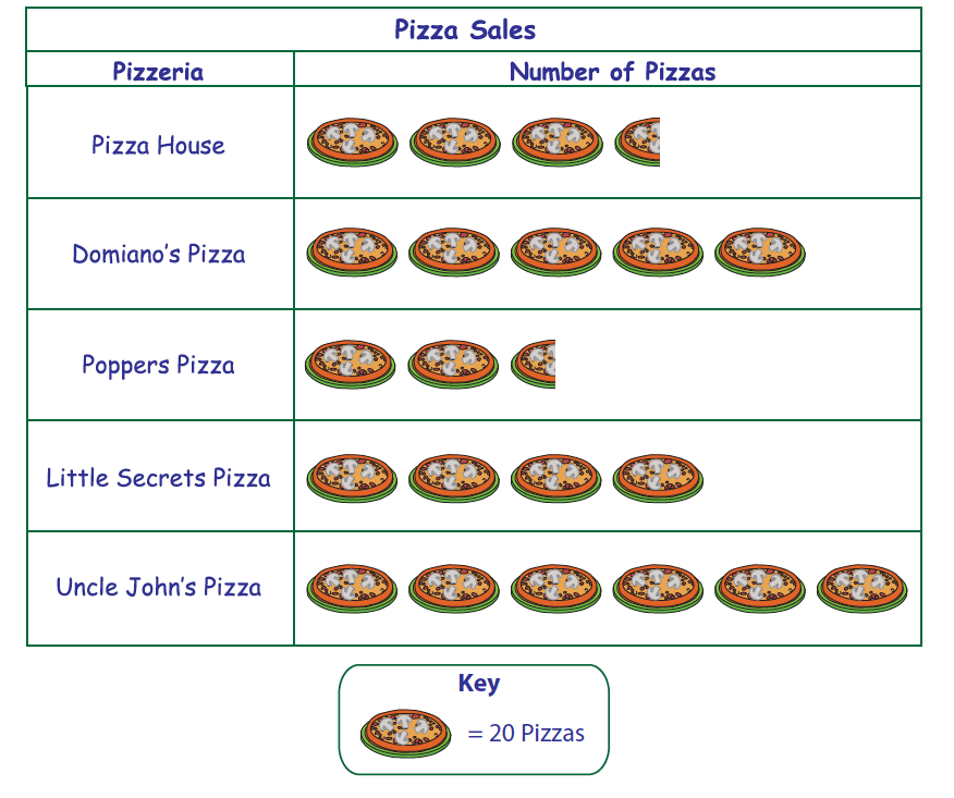
Which pizzeria has the second largest sales? 
a)
Pizza House
b)
Domiano's Pizza
c)
Little Secrets Pizza
d)
Uncle John's Pizza
19.

Look at the bar graph, "Nicest Fruit". What does the y-axis show?

a)

Types of fruit

b)

Number of people.

20.

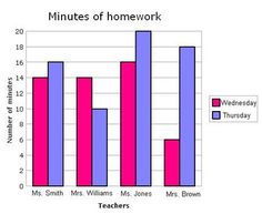
Which day had more minutes of homework?

a)

Wednesday

b)

Thursday

c)

Friday

21.
A map showing mountains, rivers, oceans, elevation is what type of map?
a)
Political
b)
Physical
c)
Thematic
d)
Nothing
22.
Using the map the Equator passes through all of the following continents except.
a)
Africa
b)
North America
c)
Asia
d)
South America
23.
Which ocean is between Africa and North America?
a)
Pacific Ocean
b)
Southern Ocean
c)
Indian Ocean
d)
Atlantic Ocean
24.
Which continent is the farthest south?
a)
Antarctica
b)
South America
c)
Australia
d)
North America
25.
Which ocean is the farthest north
a)
Indian Ocean
b)
Atlantic Ocean
c)
Arctic Ocean
d)
Pacific Ocean
26.
These imaginary lines run North and South.
a)
Ley Lines
b)
Lines of Longitude
c)
lines of Latitude 
d)
Poles
27.
The globe is divided into how many hemispheres 
a)
four 
b)
eight
c)
ten
d)
one
28.
These imaginary lines run East and West.
a)
Ley Lines
b)
Lines of Longitude
c)
lines of Latitude 
d)
Poles
29.
Based on the physical map what mountain range is on the west coast of South America.
a)
Andes
b)
Brazilian Highlands
c)
The Rocky Mountains
d)
The Himalayas  
30.

Name the ocean west of Mexico

a)

Atlantic

b)

Pacific

c)

Gulf of Mexico

d)

Labrador Bay

31.

According to the map, Michigan is _________ of Wisconsin.

a)

North

b)

South

c)

East

d)

West

32.
At which age do the least amount of teens have a cell phone?
a)
18
b)
14
c)
13
d)
15
33.
From 2008 to 2011, what does the 'Donors' impact show?
a)
A slight increase over the years
b)
A huge increase over the year
c)
A slight decrease over the years
d)
No change 
34.

Which coordinates provide the closest absolute location for New Orleans, Louisiana?

a)

39° N, 105° W

b)

30° N, 90° W

c)

25° N, 85° W

d)

45° N, 93° WThis is a wrong answer

35.

Look at the Economic Activity of Europe. Which type of land use is the most common in Europe?

a)

Trade and Manufacturing

b)

Subsistence Farming

c)

Nomadic Herding

d)

Commercial Farming

36.

What conclusion can you draw about Mexico's urban (cities) population from the bar graph?

a)

Most of the world's people live along the equator

b)

An equal number of Mexicans lived in cities in 1980 & 2000

c)

Fewer of Mexico’s people live in cities now than in 1950

d)

More of the Mexico’s people live in cities now than in 1950

37.

Look at the Resources Key. Which resources are found closest to the Tropic of Cancer?

a)

coal, diamonds, uranium

b)

precious metals, oil, uranium

c)

diamonds, hydroelectric power, oil

d)

iron, hydroelectric power, precious metals

38.

The coordinates of 20°N, 60°E will mark an absolute location in the ___ Sea.

a)

Caspian

b)

Red

c)

Black

d)

Arabian

39.

Study the key. According to the population density map, most of Canada's people live where?

a)

Along the coasts of the Atlantic and Pacific Oceans.

b)

In the central part of Canada near Hudson Bay.

c)

In the south near the USA’s border.

d)

In the north near the Arctic Ocean.

40.

Look at the key. Which of these continents has the fewest centers for manufacturing and trade?

a)

Asia

b)

Africa

c)

North America

d)

Europe

41.

What climate zone is most commonly found between 60ºN and 70º North?

a)

Ice Cap

b)

Tundra

c)

Subarctic

d)

Marine West Coast

42.

What is the second most spoken language in the Northern Territory of Canada?

a)

English

b)

French

c)

German

d)

Inuktitut

43.

Which Ethnicity and Religion is the LEAST present in Eastern Europe?

a)

Uygur and Protestant

b)

Russian and Russian Orthodox

c)

Ukrainian and Other/no religion

d)

Kazakh and Muslim

44.

In which decade was Germany's population and labor supply about equal?

a)

1970s

b)

1980s

c)

1990s

d)

2000s

45.

Which of the following letter is at approximately 60 degrees S, 40 degrees W?

a)

A

b)

D

c)

E

d)

H

46.
Which STATE is located at...
100°W, 48°N
a)
NM
b)
ND
c)
SD
d)
CO
47.

Which map is a 'birds eye view' map?

a)
b)
c)
d)
48.

Which map is a 'political map'?

a)
b)
c)
d)
49.
Another name for a Key is 
a)
Lock
b)
Meridian
c)
Legend
d)
Parallel
50.
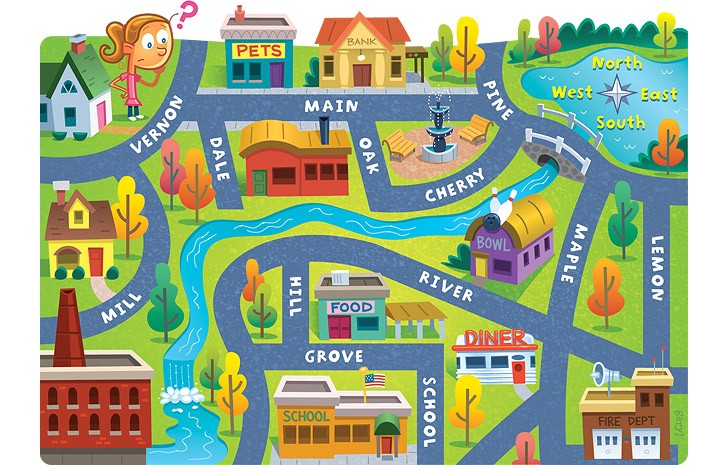
The fire dept. is ______ of the school.
a)
South
b)
East
c)
North
d)
West
51.

What are the four cardinal directions?

a)

North, South, Windy, Sunny

b)

Never Eat Slimy Worms

c)

North, South, East, West

d)

South Never Eat West

52.

Which natural resource can be found in New Zealand?

a)

coal

b)

gold

c)

lead

d)

tin

53.

Suva is the capital of what country?

a)

Fiji

b)

Kiribati

c)

Palau

d)

Vanuatu

54.

Which is not of the invasive species found in Australia?

a)

Europena rabbit

b)

feral pig

c)

kangaroo

d)

sheep

55.

What is the elevation of Jaya Peak in New Guinea?

a)

15,452 feet

b)

16,503 feet

c)

18,746 feet

d)

18,975 feet

56.

The International Date Line runs through what body of water?

a)

Atlantic Ocean

b)

Arctic Ocean

c)

Indian Ocean

d)

Pacific Ocean

57.

Which of the following cities is not on the Yangtze River?

a)

Chongqing

b)

Hong Kong

c)

Nanjing

d)

Wuhan

58.

The Persian Gulf lies between Saudi Arabia and what country?

a)

Iran

b)

Iraq

c)

Oman

d)

Yemen

59.
Which describes the relative location of the English Channel?
a)
Between Germany and France
b)
Beside the Ural Mountains
c)
Between the UK and France
d)
Between the UK and Norway
60.
Which two countries make up the Iberian Peninsula?
a)
Spain and France
b)
Spain and Portugal
c)
Norway and Sweden
d)
Italy and Spain
61.
Which ocean borders Russia to the North?
a)
Pacific Ocean
b)
Indian Ocean
c)
Atlantic Ocean 
d)
Arctic Ocean 
62.
Which mountains form the physical border between Spain and France?
a)
the Alps Mountains
b)
the Pyrenees Mountains
c)
the Ural Mountains
d)
the Appalachian Mountains 
63.
Which sea surrounds Italy?
a)
Mediterranean Sea
b)
the North Sea
c)
the Black Sea
d)
the Red Sea
64.
Which of the following causes the UK to have a mild climate?
a)
The Pacific Ocean
b)
The Arctic Ocean
c)
The Gulf Stream
d)
The Atlantic Ocean
65.
What has helped Italy become successful traders?
a)
Italy's location on the Mediterranean Sea provides access to Africa, Asia, and Europe.
b)
Location of the Alps Mountains  defends Italy against other countries.
c)
The islands of Sicily and Sardinia are not far from the coast of Western Italy.
d)
Warm air from the Sahara Desert creates a warm, dry summer for most of Italy.
66.
In what country was Acid Rain in Europe a major problem?
a)
United Kingdom
b)
Germany
c)
Russia
d)
Ukraine
67.
Name the country.
a)
Belgium
b)
France
c)
Germany
d)
Poland
68.
Name the country.
a)
Belgium
b)
France
c)
Spain
d)
United Kingdom
69.
Which mountain range is located at the Northern border of Italy?
a)
Alps
b)
Pyrenees
c)
Urals
70.
What body of water separates Europe from Africa?
a)
English Channel
b)
Rhine River
c)
Mediterranean Sea
d)
Atlantic Ocean
71.
This body of water separates England from France.
a)
English Channel
b)
French Channel
c)
English Lagoon
d)
Royal Waterway
72.
Which best describes the Sahara Desert?
a)
perfectly flat and sandy
b)
the largest desert in the world
c)
impossible for people to go across
d)
located only in the northwest corner of Africa
73.
Congo River is to Atlantic Ocean as Nile River is to
a)
Red Sea
b)
Indian Ocean
c)
Atlantic Ocean
d)
Mediterranean Sea
74.
Which river system flows through the largest rainforest in Africa?
a)
the Nile River
b)
the White Nile
c)
the Niger River
d)
the Congo River
75.
What is important about the Niger River delta?
a)
The area is rich in oil deposits.
b)
The delta is poor farming land.
c)
The area frequently dries completely up.
d)
Few people live in the area around the delta.
76.
What country is in orange?
a)
Ethiopia
b)
South Africa
c)
Egypt
d)
Nigeria