
NEW
Font size
 Worksheets
Early Americas
Total questions: 30
Worksheet time: 22mins
Which ocean is on the western side of Mexico?
Pacific
Atlantic
Artic
Indian

Mesoamerica is a region that includes....
The US and Mexico
Mexico and Central America
Central America and South America
South America
Ancient American cultures arose in difficult environments.
These cultures adapted to their challenging conditions by
developing new farming techniques and irrigation systems.
True
False

An isthmus is:
wide section of land
an island
narrow strip of land between two larger land areas surrounded by water
a Mayan holiday

Identify this biome.
Deciduous forest
Temperate Rainforest
Coniferous forest
Tropical Rainforest

The world's longest mountain range is in South America. It is labeled on this map. What is it called?
Pampas Mountains
Rocky Mountains
Mount St. Helen
Andes Mountains

Which river located in South America is the arrow pointing to on this map?
Nile River
Amazon River
Bering Strait
Andes River
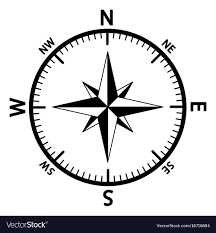
What is this direction finder called?
Briar Rose
Yellow Rose
Compass Rose
Rose Bowl
True or False: The Olmec and the Toltec were early Mesoamerican civilizations in Central America.
True
False
The Aztec, Maya and Inca all had a social structure.
True
False
Which agricultural technique allowed the Mayan to farm in the swamps?
terraces
slash-n-burn
raised beds
Which mountain range covered most of the Inca empire?
Peten Rainforest
Andes Mountains
Sierra Madres
What did the Aztecs demand of the cities they conquered?
that the leaders volunteered to be sacrificed
that the people gave all their quetzal feathers
that they people pay tribute to the emperor
the citizens give up their religion
How did the Inca send messages to distant places?
trained pigeons
Relay messengers
a barter system with traders
Which of the following people in the Mayan civilization would be most likely to farm?
ruler
merchant
priest
peasant

The Inca civilization is located in which mountain range?
Andes
Sierra Madre
Sierra Nevada
Himalayas
Which is the largest river system in North America?
Amazon
Mississippi
Andes
Nile
Where did the Maya live?
Central Mexico
Yucatan Peninsula
South America mainly Peru

The Aztec Empire lived in central ___________.
Asia
Mexico
Panama
Cuba

What system of farming did the Inca develop in order to farm in the mountains?
Chinampas
Irrigation
Aqueducts
Terrace Farming


What color represents where the Inca civilization was?
blue
red
gray
green

Who had the most power in Mayan society?
Priests
Rules
Military Commanders
Warriors

Hernan Cortes is responsible for the destruction of which early American civilization?
The Aztec
The Inca
The Olmec
The Maya

The Aztec expanded through what modern-day country?
Mexico
Peru
El Salvador
Brazil

