
 Worksheets
Earth Science SOL Review
Total questions: 500
Worksheet time: 13hrs 41mins
The independent variable is
the variable I change
the variable that gets changed
in another lab
one of five variable combinations

Name two types of variables used by scientists.
Independent and dependant
Relational and dependant
Relational and independent
Mathematical and relational

Why do scientists need to come up with a hypothesis?
To give an educated guess for their question.
Because they need something to do.
Because making hypothesis are fun.
Its important so they can practice their analysis.

What is the first step of the scientific method?
Analysis
Question or problem
Measuring
Communicating results

Difference between observation and inference.
Observation is an interpretation of your sorroundings.
Inference involve senses.
When you infer you interpret what you observed with your senses.
This are not skills used by scientists.

Observing involves how many senses?
4
6
5
3

This is a branch of science.
Chemistry
Physics
Biology
All are correct.

Science is important because.
To improve communication.
To solve problems.
To enhance education.
All are correct.

Skills used by scientists.
Phenomena, world.
Problem,variables.
Compare, observe, deduct, measure.
None.

Tools and equipment used by scientists.
Hammer, nails, screwdrivers,sandpaper.
Paint, colors, brushes, oil pastels.
Test tubes, beakers, measuring cups, droppers., microscopes.
sneakers, basketballs, volleyballs.
What is the last step of the scientific method?
Measuring
Analyzing
Communicating results.
Drawing conclusions
This shows the changes in elevation of Earth's surface
GPS
political map
topographic map
cross section

What name is given to the darker numbered lines on the map?
roads
index contour
contour interval
waves

Which locations have the same elevation?
A and C
B and E
C and I
F and G
What type of map would be most helpful if you were looking for a steep trail to hike?
Geologic Map
Road Map
General Use Map
Topographic Map

What type of map is this an example of?
Geologic Map
Projection Map
Topographic Map
3D Map
What would use this type of map for?
To calculate distance from one town to another.
To determine the best trail for a hike.
To investigate the type and age of rocks present.
If you find a fossil of a mammoth tusk and want to know what time period it lived in, what type of map could you use?
Geologic Map
Topographic Map
Road Map
General Use Map
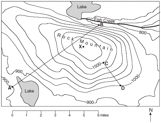
What is the contour interval of this map?
100 ft
500 ft
1000 ft
15000 ft

What is the highest elevation on this map?
300 ft
280 ft
Between 291 ft and 299 ft
290 ft

What is the lowest possible elevation on this map?
231 ft
between 231 ft and 239 ft
240 ft
250 ft
___________ describes the difference between the high and low elevations on a map.
Sea level
relief
peak
topography

Match the topographic map to its profile.


How can you tell a map shows a steep slope?
The lines are far apart from each other
The lines are close to each other


Geologic cross sections like the ones pictured show what rocks look like below the ground.
True
False


Which locations have the same elevation?
A and C
B and E
C and I
F and G

Points A, B, X, and Y are locations on a map. Elevations are shown in feet.
Which diagram best represents the topographic profile along a straight line from point A to point B?



The variable that I change
constant
independent
dependent
control
Why do scientists use the scientific method?
To make sure they get credit for their discoveries.
To make sure their results are valid and can be performed by other scientists.
So that other scientist don't get mad at them
Because their 6th grade science teacher told them to.
If plants are exposed to sunlight, then they will grow taller.
What part of the scientific method is this an example of?
Procedure
Hypothesis
Question
Results
The summary at the end of an experiment that explains the results is called the...
conclusion
procedures
materials
hypothesis
What is a hypothesis?
An educated guess stating what you believe will be the result of your experiment
A random guess
A statement of the outcome of your experiment
Step by step directions for your experiment
What are the procedures step in the experiment?
The conclusion to your experiment
The materials needed to complete experiment
Step by step directions of how to complete your experiment
An educated, best guess
The manipulated variable is the ONE thing you _____.
change on purpose
control or keep constant
measure
The variable that is being measured or observed is called the _______________.
manipulated variable
responding variable
controlled variable
An experiment is performed on plants to see how different liquids affect plant growth. Each plant in the experiment is given a different liquid: water, apple juice, or milk. What variables should be kept constant/controlled?
type of plant, flower pot, soil, and amount of sunlight
water, apple juice, milk
only the amount of sunlight
type of plant only
What is a constant/control in an experiment?
Things that do not change in an experiment. It's the variable that stays the same. You can have many variables stay the same.
It's the variables that the scientist changes in the experiment.
It's the variables that are being measured in an experiment.
A series of steps used by scientists to solve a problem or answer a question is called...
the scientific method.
a recipe.
data collection.
metric system.
A student is conducting an experiment to determine whether a construction paper air plane will fly faster than an airplane made from notebook paper. What would be an appropriate hypothesis?
If I make a paper airplane from notebook paper, then it will fly faster than construction paper.
If I throw an airplane, it will fly.
If I fold the airplane a special way, then it will fly the furthest.
I think the construction paper air plane will fly faster.
Distance, measured in degrees, north or south of the equator
latitude
longitude
distance, measured in degrees, east or west of the prime meridian
latitude
longitude
Key that explains symbols on a map
map legend
map scale
map view
Relates distances on a map to actual distances
map legend
map scale
map view
Shows Earth's surface from above
profile view
map view
First in rank
prime
last
Shows an object as though you were looking at it from the side
profile view
map view
Area on Earth where people use the same time
time zone
prime meridian
longitude
latitude
Hight above sea level
elevation
relief
slope
aerial
Shows vertical slice through rocks below Earth's surface
cross section
relief
slope
topographic map
Shows the surface geology of an area
geologic map
topographic map
Measured steepness of the land
slope
relief
elevation
aerial
Shows detailed shapes and natural and human made features of Earth's surface
topographic map
geologic map
Longitude line 180 degrees east or west of the prime meridian
International Date Line
prime
relief
elevation
Which locations have the same elevation?
A and C
B and E
C and I
F and G
Points A, B, X, and Y are locations on a map. Elevations are shown in feet.
Which diagram best represents the topographic profile along a straight line from point A to point B?

What is an example of modern mapmaking?
Mapmakers using repeated, first-hand experience of the landscape to create a map.
Mapmakers and scientists using photos from airplanes or satellites to create a map.
Mapmakers and scientists using historic and modern data by traveling on foot.
Mapmakers using pictures taken when traveling to create a map of the landscape.
GIS stands for
Geographic Information System
Generic Information System
Geological Information System
Geographic Information Sharing
why the Use of GIS is necessary
Saves Times
Handle large datasets
Maps can be created and edited faster
All of the above
What geographic tool is an actual model of the Earth?
globe
map
GPS
satellite imagery
What geographic tool uses at least four satellites to provide locations on the Earth?
globe
map
satellite imagery
GPS
What geographic tool is limited because it cannot show streets and small towns?
globe
map
satellite imagery
GPS
How is a globe more accurate than a map?
a globe is a 3 dimensional model of the Earth, but a map is flat
a globe can show streets and roads, but a map cannot
a globe can show all of the continents at once, but a map cannot
a globe can be used to navigate from one town to another, but a map cannot
A visual representation of an area
globe
map
aerial photograph
GPS
Geographers only use one tool/technology when they study the world.
False
True
Maps are the least useful tool in geography.
True
False
Technologies like GPS and GIS help geographers with new and detailed information.
True
False
Google maps is an example of a GIS.
True
False


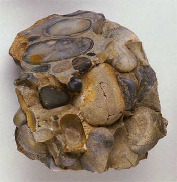


A crystalline structure means
disorderly internal structure
atoms or ions are arranged in an orderly repetitive manner
A naturally formed, inorganic solid that has a definite crystalline structure is known as a:
Rock.
Compound.
Element.
Mineral.
In class you learned that there are five criteria that make a mineral, a mineral. Based on what you learned, what are the five criteria?
Solid, Naturally Occurring, Inorganic, Fixed Chemical Formula, and Crystal Structure.
Fixed Chemical Formula, Organic, Living, Bright Color, and Crystal Structure.
Inorganic, Naturally Occurring, Plastic, Solid, and Fixed Chemical Formula.
Organic, Naturally Occurring, Crystal Structure, Solid, and Liquid.
Coal is NOT a mineral because
It is not solid.
It is not naturally occurring.
It is organic.
It is inorganic.
Native copper is a solid, inorganic substance found in Earth. What would it be classified as?
Soil.
Animal.
Mineral.
Vegetable.

Read the description below. Which detail(s) show that Sulfur is a mineral?
At room temperature Sulfur is a yellow crystalline solid. It's has a chemical formula of S8 and is found near volcanic vents.
HINT: There may be more than one answer!
It is yellow.
It is a solid.
It can be defined by a chemical formula.
All of the above.

Plastic is a clear substance that is a solid. Plastic has a fixed chemical formula and is a man - made product.
Is plastic a mineral or not?
Please select two answers.
Yes, plastic is a mineral because it is formed from a man - made substance.
No, plastic is not a mineral because it is not naturally occurring in the environment.
Yes, plastic is a mineral because it is a solid substance that has a fixed chemical formula.
No, plastic is not a mineral because it does not have a crystal structure.
Read the description below. Use the definition of minerals to choose the correct statement about ivory.
Ivory is a hard, solid, white material that comes from the tusks, or teeth, of animals, usually elephants.
Ivory is a mineral because minerals either come from living things or are man - made.
Ivory is a mineral because minerals are always white in color.
Ivory is not a mineral because minerals don't come from living things.
Ivory is not a mineral because minerals are not solids.

Guess the Mineral!
This mineral is found in your toothpaste. It plays a key role in keeping your teeth healthy and strong. What is it?
Zinc.
Copper.
Fluorite.
Salt.

Guess the Mineral!
This mineral can be crushed into a white powder that is widely known as baby powder. This powder has the ability to absorb moisture, oils, and odor. What is the name of the mineral?
Zinc.
Talc.
Fluorite.
Salt.

Guess the Mineral!
This mineral is the hardest naturally occurring mineral. It is most often used in jewelry but can also be used on the tips of saw blades. What is the name of the mineral?
Fluorite.
Talc.
Diamond.
Sulfur.
Fill in the blank with the correct answer choice.
Minerals can sometimes be thought of as the ______________________ of rocks. Minerals are the small particles that make up the materials in different types of rocks. Igneous, metamorphic, and sedimentary rocks all contain minerals.
Solid.
Building Blocks.
Crystal Structure.
Fixed Chemical Formula.
One way that minerals form is by the crystallization of cooling
magma.
water.
Minerals form ___________
when magma and lava cool.
when metamorphism occurs.
from hot water solutions where water evaporates.
all of the above.


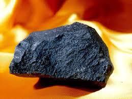


This rock started as lava that cooled and solidified. Then it was heated and put under pressure, which changed it chemically. What type of rock is this?
Sedimentar
Igneous
Metamorphic


What are the 3 major types of rocks?
Igneous, Metamorphic, Sedimentary
Metamorphic, Igneous, Cementation
Brown, Red, Gray
Streak, Hardness, Breakage

The individual particles that make up a rock are known as _____
Grains
Textures
Metamorphs
Lava

Two ways to describe types of igneous rocks are _____
Extrusive and Intrusive
Foliated and Non-Foliated
Clastic and Biochemical
Black and Gray

Intrusive rocks
Forms at earth's surface
Has a fine-grained texture
Form underground

Extrusive rocks
Forms underground
Has a coarse-grained texture
Cool quickly

A slow cooling igneous rock will have _____ crystals
large
small
average
black

This type of rock can contain fossils.
sedimentary rocks
metamorphic rocks
extrusive igneous rocks
intrusive igneous rocks

This rock is formed in layers.
Sedimentary
Igneous
Metamorphic

This rock is changed by heat and pressure.
Sedimentary
Igneous
Metamorphic
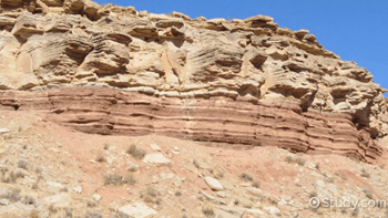
What factors can lead to the formation of a sedimentary rock?
melting and solidification
extreme heat and pressure
compaction and cementation

Which 2 statements below correctly identify the difference between a rock and a mineral?
Rocks are mixtures and minerals are not.
Rocks can be organic and minerals are always inorganic.
Rocks are harder than minerals.
Rocks are the building blocks of minerals.
The movement of the tectonic plates is caused by
the rotation of the Earth.
convection currents in the Asthenosphere
the gravity of the iron-nickel core.
the Moho discontinuity.
In some areas of the world, like California and Japan, earthquakes are a common occurrence. How can this best be explained?
The strong ocean currents are undermining both areas causing earthquakes.
Both areas are located near the edge of the Pacific Ocean, the unstable sand causes earthquakes.
Both areas are subjected to strong ocean wind and waves that causes earthquakes.
Both areas are on the boundary of active plates, the motion of the plates causes earthquakes.
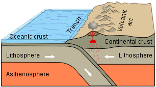
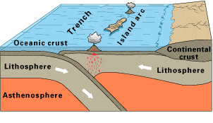
Observe this diagram of a plate boundary. One statement BEST describes what is happening. It is that
the oceanic crust is melting.
the denser ceanic crust is subducting under the less dense oceanic crust
volcanic islands are forming.
the tectonic plates are moving away from each other.
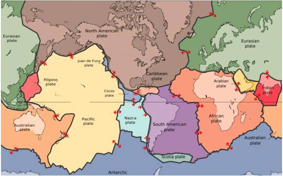
The map in the picture shows tectonic plate boundaries. This map would be useful in predicting the location of future
droughts
hurricanes
earthquakes
tornadoes
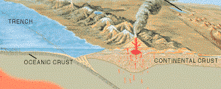
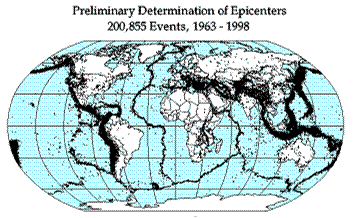
Earthquake epicenters (center of where the earthquakes started) were mapped for a 35 year period in the diagram above. The black dots indicate these epicenters. The black dots appear along what feature on Earth?
hot spots
plate boundaries
rift zones
sea floor spreading
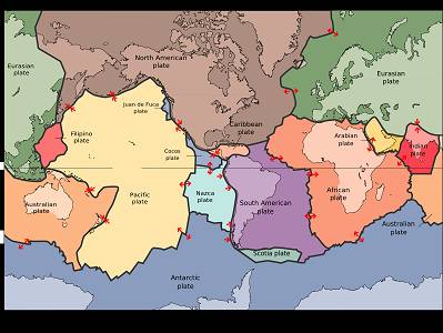
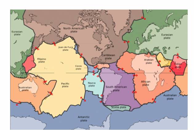
Where are earthquakes MOST LIKELY to occur?
close to the equator
close to the center of tectonic plates
at divergent or convergent plate boundaries
at transform plate boundaries
The 2004 Indian Ocean tsunami was caused by a shift in two plates that pushed one section of the sea floor under another section of the sea floor by 5 meters. What type of boundary is this?
divergent
convergent
transform
metamorphic
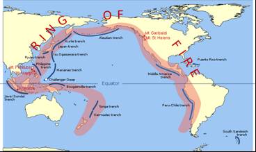
___________ currents in the Earth's asthenosphere cause plate to shift at their boundaries. This movement also causes earthquakes and volcanic activity.
conduction
convection
radiation
ocean
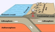
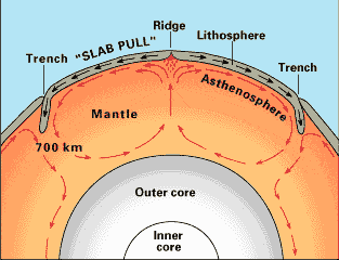
What is the source of energy that drives plate movement?
the subducton of the sea floor
the different densities of the oceanic and crustal plates
convection currents in the asthenosphere
the friction force between the plates that move past each other
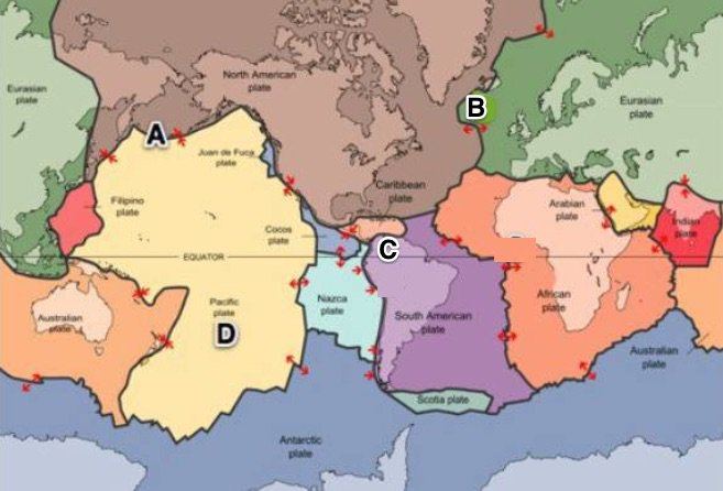
Where would sea floor spreading most likely occur?
At convergent boundaries (oceanic vs. oceanic)
At convergent boundaries (oceanic vs. continental)
At divergent plate boundaries (oceanic vs. oceanic)
At transform plate boundaries
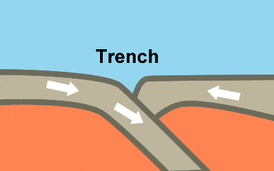
The Marianas Trench, where the Pacific Plate descends under the leading edge of the Eurasian Plate, is the deepest sea floor in the world. These ocean trenches form when two oceanic plates collide
and the older, less dense of the two plates rides over the edge of the older plate.
when convection currents in the mantle force the older plate downward.
and the younger, denser of the two plates, rides over the edge of the older plate.
and the plates are approximately the same age and density.


Earthquakes happen along a fault line. Which of the following is NOT true about faults?
It can be found on land.
It can be found under the sea.
It is where fault cyclone starts.
It is a break in the Earth’s crust
Energy from inside the Earth makes the ground move. Which of the following is the reason why there is no movement right away?
Friction causes the delay on the movement of the ground.
There is no movement right away because of the vibration of the rocks.
There is no movement right away because of the bending of the rocks.
The rapid release of energy causes the delay of the movement of the ground.
Earthquakes are common occurrence in Japan, Indonesia, and Philippines. Why is this so?
Japan, Indonesia and Philippines are surrounded by seas.
Japan, Indonesia and Philippines are located near the equator.
Japan, Indonesia and Philippines are considered archipelagic countries.
Japan, Indonesia and Philippines are found within the Pacific Ring of fire.
Which of the following refers to the place where the earthquakes start?
Fault
Focus
Epicenter
Fault plane
What do you call the spot above the focus on the surface of the Earth?
Fault
Crust
Focus
Epicenter
Scientists use different ways to describe how powerful an earthquake is. Which method refers to noting the effects of the earthquake on people, structures, and the surroundings?
Focus
Intensity
Epicenter
Magnitude
Which term refers to the released energy of an earthquake?
Focus
Intensity
Epicenter
Magnitude
Which factor keeps the rocks from slipping past each other?
The depth of the rocks.
The bending of the rocks.
The arrangement of rocks.
The roughness of the rocks.
What do you call the phenomenon that refers to the fast movement between two sides of a fault wherein the friction is overcome resulting to a sudden movement or shaking of the ground?
Stick-slip
Stick-bend
Stick-shake
Stick-vibrate
What Philippine Agency is concerned in monitoring fault movement?
Department of Labor and Employment (DOLE)
Department of Environment and Natural Resources (DENR)
Philippine Institute of Volcanology and Seismology (PHILVOCS)
Philippine Atmospheric, Geophysical and Astronomical Services Administration (PAGASA)
Scientists use different ways to find out if a fault is active. Which one is NOT included?
Scientist created a fault model.
Scientist observed the surroundings.
Scientist checked the country’s historical record.
Scientist studied the past and present vibrations.
What is the other term used to describe Intensity V?
Strong
Devastating
Very strong
Destructive
Which of the following choices is properly associated?
Intensity III : Weak
Intensity 9: devastating
Magnitude 5: slightly felt
Magnitude II: scarcely perceptible
What will most likely happen every time a fault slips?
The rocks will be stuck together.
There will be no movement at all.
There will be movement right away.
The rocks will suddenly slip and will generate an earthquake.
Not every fault movement beneath the sea will produce a tsunami. Which of the following fault movements will result to such occurrence?
String movement
Vertical movement
Sideward movement
Horizontal movement
Which of the following is/are true about tsunamis?
It is related to tides.
It is a giant tidal wave.
It is due to the upward movement of rock on land.
It is due to the upward movement of rock at the seafloor.
What happens to the tsunami when it reaches the shore?
The wave speeds up
The wave breaks down.
It slows down and grows in height.
The wave speeds up and grows in height.
Which of the following refers to the vibrations produced by an earthquake?
Tidal waves
Seismic waves
Pressure waves
Sea-surface waves
What happens when seismic waves travel deeper into the crust?
Seismic waves speed up.
Seismic waves disappear.
Seismic waves slow down.
Seismic waves maintain their speed.
The seismic waves travel through the Earth and carry information from the interior to the surface. All of the following statements is true, EXCEPT
The seismic waves are reflected.
The seismic waves bounced back.
The seismic waves are refracted or bent.
The seismic waves are stocked on the rocks.
A broad volcano with gently sloping sides is a ________________
Shield
Cinder Cone
Fire Fountain
Composite
A small volcano with steep sides.
cinder cone
composite
strata
shield
A steep-sided volcano formed from layers of lava and ash.
Strata or composite
shield
cinder cone
fire fountain
Lava that is very thin and runny probably
has low silica content
is high in silica
Pyroclastic material forms when
magma explodes into the air and travels down the mountain very fast
lava flows calmly from a crack in the Earth´s crust
magma remains underground too long
lava flows underwater
A combination of explosive and quiet eruptions will create a
composite volcano
shield volcano
cinder cone volcano
Where are volcanoes most likely to form?
along plate boundaries
near the center of continents
near water
on the moon
One major belt of volcanoes that surrounds the Pacific Ocean
Ring of Fire
Ring of Asia
Ring o' earthquakes
Ring a ding ding
A bowl shaped area that may form at the top of a volcano around the central vent
crater
vent
tube
leftovers
An area where material from deep within Earth's mantle rises through the crust and melts to form magma.
hot spot
rift zone
hot soup
hot mamma

Shield Volcano

Where do volcanoes typically form?
At plate boundaries.
In the middle of tectonic plates.
What is an active volcano?
A volcano that has erupted at least once in the last 10,000 years.
A volcano that hasn’t erupted in the last 10,000 years, but could still erupt.
A volcano that should never erupt again.
What is a dormant volcano?
A volcano that has erupted at least once in the last 10,000 years.
A volcano that hasn’t erupted in the last 10,000 years, but could still erupt.
A volcano that should never erupt again.
What is an extinct volcano?
A volcano that has erupted at least once in the last 10,000 years.
A volcano that hasn’t erupted in the last 10,000 years, but could still erupt.
A volcano that should never erupt again.
What kind of eruptions do composite volcanoes have?
Explosive eruptions.
Quiet eruptions.
What kind of eruptions do shield volcanoes have?
Explosive eruptions.
Quiet eruptions.

Statue of Liberty has changed colors over time because oxygen has caused the surface of the copper it is made of to change into a new chemical (just like copper pennies turn green). What kind of weathering is this?
chemical weathering
physical weathering

Acid rain has worn away the features on this statue. What type of weathering is this?
chemical weathering
physical weathering

The rocks in this stream have gradually worn down from the water and particles in the water rubbing on them over time (abrasion). What kind of weathering is this?
chemical weathering
physical weathering

This freezing water is expanding, causing the crack in the rock to widen (frost action). What kind of weathering is this?
chemical weathering
physical weathering

These plant roots are widening cracks in the rock. What kind of weathering is this?
chemical weathering
physical weathering

This arch was formed by wind and particles carried by the wind rubbing on the rock over time (abrasion). What type of weathering is this?
chemical weathering
physical weathering

Burrowing animals like this one dig holes in the ground, breaking up soils. What kind of weathering is this?
chemical weathering
physical weathering

Does this show signs of physical or chemical weathering?
Physical Weathering
Chemical Weathering

Does this show signs of physical or chemical weathering?
Physical Weathering
Chemical Weathering

Does this show signs of physical or chemical weathering?
Physical Weathering
Chemical Weathering

Does this show signs of physical or chemical weathering?
Physical Weathering
Chemical Weathering

Does this show signs of physical or chemical weathering?
Physical Weathering
Chemical Weathering

Does this show signs of physical or chemical weathering?
Physical Weathering
Chemical Weathering

Wetlands store flood waters. How is this beneficial? Choose the best answer.
Its not really beneficial because this may flood peoples homes.
It releases the water is increments which will really increase the wildlife in that area.
It releases the water in increments ( a little at a time) which slows the water down thus slowing erosion.
Its really not beneficial because this will flood the habitats of the wildlife living there.

Rain washing soil away from a hillside is an example of
Abrasion
Erosion
Deposition
Weathering
Water is able to move rocks as big as a boulder.
True
False
carries away materials
Erosion
Deposition
Weathering
Rock Cycle
The process of sediment being dropped off in a new place is called
Abrasion
Erosion
Deposition
Weathering

A delta is an example of
Erosion
Weathering
Sediment
Deposition

Sea caves are coastal landform made by
Erosion
Deposition
Small, broken down pieces of rock are called
sedimentary rock
sediment
smaller rocks
crumbs


How are dams and levees alike?
both control floods
both control weathering
bath are natural barriers
both prevent coastal erosion
What is the name for an area of flat land next to a river?
floodzone
wetplain
saturated zone
floodplain
When deposits build up in a harbour or lake, they need to be removed. This process is called...
dredging
dodging
delta
digging
What is a Karst Landscape?
A distinctive landscape made of bare limestone and formed by coastal erosion
A distinctive landscape made of bare granite and formed by mechanical weathering
A distinctive landscape made of bare sandstone and formed by chemical weathering
A distinctive landscape made of limestone and formed by chemical weathering
The sudden and dramatic movement of snow and ice down a mountain is called
earthquake
avalanche
flash flood
storm surge
the continuous process by which water is circulated throughout the earth through various processes
precipitation
codensation
water cycle
evaporation
when water in the clouds gets too heavy, the water falls back to the Earth as rain, sleet, snow, hail, mist, etc.
precipitation
codensation
transpiration
evaporation
the process of a gas changing to a liquid (gas to liquid) as it cools
precipitation
codensation
transpiration
evaporation
the process of a liquid changing to a gas at the surface of a liquid (liquid to gas)
precipitation
codensation
water cycle
evaporation
evaporation of water from plants (plants sweating)
precipitation
codensation
transpiration
evaporation
the process in which water pools in large bodies like oceans, seas, and lakes
surface runoff
groundwater
accumulation
subsurface runoff
water from precipitation that flows over Earth’s surface
surface runoff
groundwater
accumulation
subsurface runoff
water from precipitation that flows in underground streams, drains, or sewers
surface runoff
groundwater
accumulation
subsurface runoff
frozen water turns directly into water vapor (ice to gas), skipping the melting phase into a liquid
sublimation
infiltration
percolation
water that seeps down into the soil
sublimation
infiltration
percolation
water that filters through holes in the soil due to gravity
sublimation
infiltration
percolation
a material not allowing liquid to flow through
pervious surface
impervious surface
a material that allows liquid to pass through it
pervious surface
impervious surface
area where the zone of aeration and zone of saturation meet
water cycle
recharge zone
water table
an area where surface water from streams, ponds, or lakes enters into an aquifer
zone of saturation
recharge zone
zone of aeration
an area underground with water filled pores
zone of saturation
recharge zone
zone of aeration
an area underground with air filled pores
zone of saturation
recharge zone
zone of aeration
underground rock layers that store and allow the flow of water
permeability
aquifer
porosity
rocks ability to let water pass through it
permeability
aquifer
porosity
Which of the following are some of the major mineral resources of Virginia? (Released VA DOE SOL Question)
Diamonds, sapphires, and rubies
Coal, granite, and limestone
Sulfur, fluorite, and cobalt
Gold, silver, and copper

In which province would clay, sand, and gravel deposits be found? (Released VA DOE SOL Question)
Appalachian Plateau
Valley and Ridge
Blue Ridge
Coastal Plain
Caves are found in Virginia's Valley and Ridge province because the area is underlain by - (Released VA DOE SOL Question)
granite
shale
gneiss
limestone
The folding and faulting found in the rocks of the Blue Ridge Mountains of Virginia were created by - (Released VA DOE SOL Question)
collisions of continental plates
wave action of prehistoric ocean
the Coriolis effect
heating and cooling of the prehistoric atmosphere

Which region of Virginia is classified as the Piedmont? (Released VA DOE SOL Question)
1
2
3
4
From the Piedmont province to the Coastal Plain, the land drops as much as several hundred feet. This drop, which is abrupt in some places and gradual in others, is known as the Fall Line. What features(s) would rivers exhibit when they cross the Fall Line? (Released VA DOE SOL Question)
Waterfalls and rapids
Sudden increases in water volume
Significantly higher water temperatures
Shallow beds and slow currents
The fossil fuel found in greatest abundance in Virginia is - (Released VA DOE SOL Question)
oil
coal
natural gas
methane
Many quarries in Virginia produce crushed stone. What industry uses the most crushed stone? (Released VA DOE SOL Question)
Plastics
Construction
Electronics
Steel
The presence of many metamorphic rocks in Virginia is an indication that the area has been subjected to - (Released VA DOE SOL Question)
intense heat and pressure
limited volcanic activity
deep ocean venting
massive solar bombardment
amount of open space between rock particles
permeability
aquifer
porosity


ice and glaciers

area where the saturation zone and unsaturation zone meet
water cycle
recharge zone
water table
an area underground with water filled pores
saturation zone
recharge zone
unsaturation zone
underground rock layers that store and allow the flow of water
permeability
aquifer
porosity

provide habitats, help control floods, purify water
purify the land, help control flood, provide habitats
Wetlands help control flood. How is this beneficial? Choose the best answer.
Its not really beneficial because this may flood peoples homes.
It releases the water is increments which will really increase the wildlife in that area.
Absorbs waters from heavy rains.
Its really not beneficial because this will flood the habitats of the wildlife living there.
Pollution that cannot be traced to a single point because comes from many sources
estuary
water shed
non point source pollution
point source pollution
A _____ is an artificial lake built for storage of water fpr human use
running water
reservoir
storage

What is the energy source for the water cycle?
sun
wind
rain
oceans
Which of the following is an example of precipitation?
sleet
hail
snow
all of the above
What percent of the earth is covered by water?
20%
50%
70%
85%

The edge of highland that surrounds a drainage basin is:
A Meander
The Watershed
A Waterfall
The Bank

The flood plain of a river is:
Very hilly
Steep sloping
In the mountains
Generally flat
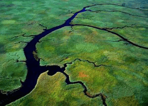
A stream or river that joins the main river is:
A tributary
A confluence
The mouth
A Canyon

The point at which two rivers or streams meet is called:
A tributary
A coincidence
A confluence
A delta

Rivers erode the land to make what shaped valleys?
U shaped
C shaped
T shaped
V shaped

Flood plains and Deltas are found in which part of a river system?
Upper course
Lower course
Middle course
Every part/course

Waterfalls and rapids are found in which course of the river?
Upper course
Lower course
Middle course
All parts/courses
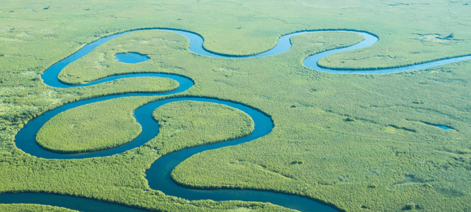
Meanders are what type of feature?
A steep bank
Turbulent water
Winding curve shapes
A U shaped lake

Which statements below are true about the source of a river? (more than one correct answer)
Found in
The start of a river
A stream or spring often found in the mountains/highland
Deposits sediment forming large deltas

The Iguazu falls on the Brazil and Argentina boarder is an example of what type of river features?
Large Deltas
Large Mouths
Large Waterfalls & Rapids
Large Oxbow lakes
What is an energy resource?
a natural product that can be changed into other energy forms to do work
something formed from buried plants and animals
force that opposes motion
resource that can never be replaced
What are nonrenewable resources?
energy sources that are replaced faster than they are used
energy sources that can never be replaced or are replaced more slowly than they are used
a natural product that can be changed into other forms of energy to do work
What are fossil fuels?
energy producers that comes from radioactive elements
a natural product that can be changed into other energy forms to do work
energy resources that formed from buried plants and animals that lived a very long time ago
resources that are replaced faster than they are used
All of the following are fossil fuels EXCEPT
oil
water
coal
natural gas
All of the following are uses of fossil fuels EXCEPT
to produce electrical energy
gasoline
to heat homes
windmills
What changes chemical energy from fossil fuels into electrical energy?
electric generators
nuclear fission
power plants
windmills
Where does nuclear energy come from?
Electric generators
radioactive elements
fossil fuels
geothermal energy
Nuclear fission is a process where the nucleus of an atom splits into two smaller nuclei.
True
False
Splitting atoms creates nuclear energy and what other type of energy?
electrical
thermal
sound
light
What is a renewable energy resource?
an energy source that is replaced more slowly than they are used
an energy source that can never be replaced
an energy source that is replaced faster than they are used
a fossil fuel
What is a device that changes solar energy into electrical energy?
wind turbine
perpetual motion machine
electric generator
solar cell
Geothermal energy is made from water being pumped underground near hot rock, turning it to steam.
True
False
Biomass is nonorganic matter that gives off energy when burned.
True
False
All are disadvantages of using Fossil Fuels EXCEPT
Renewable resources
Nonrenewable resources
risk of oil spill
produces acid precipitation
All are advantages of using Nuclear energy EXCEPT
no air pollution
Renewable resource
concentrated energy form
All are disadvantages of Solar energy EXCEPT
expensive
Nonrenewable resource
works best in sunny areas
All are advantages of using Wind energy EXCEPT
Renewable Resource
Inexpensive
Nonrenewable Resource
no pollution
All are disadvantages of using Water energy EXCEPT
Nonrenewable resource
needs dams that hurt the ecosystem
needs rivers
All are advantages of using Geothermal energy EXCEPT
Nonrenewable resource
Renewable resource
almost endless source
little land needed
All are disadvantages of using Biomass as an energy source EXCEPT
needs a lot of farmland
Nonrenewable resource
produces smoke

