
Font size
 Worksheets
Unit 1 Review
Total questions: 35
Worksheet time: 43mins
What motivated Hernando de Soto to explore Georgia?
He believed that there were civilizations further north and wanted to spread the Christian religion to them.
He thought that there were larger empires in Georgia and that he could gain more glory by conquering them.
He wished to avoid conflict with the larger English and French colonial armies in Florida.
He heard stories about large gold deposits further north and went north to search for them.

Which section is Georgia Located?
1
2
3
4
___________ built missions on the Barrier Islands to convert the American Indians.
Spain
Italy
England
Poland
Why was England interested in Southeastern region of North America?
interested in converting American Indians to Judaism.
interested in profiting from trapping and trading animal furs.
interested in producing raw materials to send back to manufacture goods.
interested in mining for gold and silver to fill the monarch's treasury.

Which number is the Coastal Plains?
1
2
3
4
5

Which number is the Appalachian Plateau?
1
2
3
4
5

Which number is the Blue Ridge?
1
2
3
4
5

Which number is Piedmont
1
2
3
4
5

Which number is the Ridge & Valley
1
2
3
4
5

Using this map, which geographic region boarders the Coastal Plains?
Appalachian Plateau
Blue Ridge
Valley & Ridge
Piedmont
Coastal Plains
How does Savannah provide goods to Georgia's citizens?
The International Airport is located in Savannah
Savannah deepwater port is a major automobile distribution hub.
Savannah Railroad connect to Los Angeles Railroads
I-285 and I-75 connect Savannah to all other major cities in Georgia
Why did the Spanish fail to establish lasting colonies in Southeast America?
The new diseases kept wiping colonies out.
The Spanish had poor planning on how to establish a colony in a new world.
The British and the Native Americans killed them all off.
The Spanish would constantly move once they realized there was no gold in the area.

Where is Georgia located?
1
2
3
4
5
Why did the Spanish fail in converting the American Indians?
The American Indians did not trust the Spanish
War with the British put their attention on the British instead of the Indians
Hernando de Soto starved so many of them, that they fled the area.
The Spanish brought so many new diseases, that many ended up dying before being converted.
Which statement correctly locates the state of Georgia by hemisphere, continent, nation, and region?
Western Hemisphere, North America, United States, Southeast region
Southern Hemisphere, North America, United States, Southeast region
Northwest Hemisphere, North America, United States, Southern region
Northern Hemisphere, North America, United States, Southwest region
How was the location of Mississippian villages related to their diets?
Mississippian American Indians relied on fish as their main food source.
Mississippian American Indians needed access to water to practice large-scale agriculture
Mississippian American Indians used rivers to transport crops from distant fields to their villages.
Mississippian American Indians used rivers to find new sources of fruit and nuts to gather for food.
What two cities are Georgia's Deepwater ports?
Atlanta & Augusta
Macon & Columbus
Brunswick & Savannah
Albany & Valdosta
/Which of the following is an example of early agriculture in Georgia?
American Indians roamed from place to place as hunters and gatherers.
American Indians created towns that allowed them to grow and harvest crops.
American Indians traded their furs for food from the Spanish.
American Indians planted food and harvested crops from the land until they moved for more fertile land.
Why the Chattahoochee River is important to Georgia today?
Important food sources for locals
Major waterway for businesses
Major tourist attraction along the Georgia/Alabama boarder
Major source of fresh drinking water
Describe the Fall Line
The decrease in elevation that separates the Inner Coastal Plains from the Outer Coastal Plains
The decrease in elevation that separates the Piedmont and Coastal Plains
The long valley that separates the Appalachian Plateau and the Blue Ridge
The boarder line that separates the state of South Carolina from Georgia
Select 3 of the 5 states that boarder Georgia:
Tennessee
North Carolina
Mississippi
Virgina
Florida
Why were manmade lakes created in Georgia?
Tourist attractions for fishing
Provide defense from the French
To provide hydroelectricity
To create beaches
Which of these is the BEST explanation for the contrast between Spain’s motives to explore and settle the North American continent and England’s motives?
Spain wanted to colonize North America, and England only wanted to take home the wealth of the New World.
Spain wanted to claim land in the New World to use for sending their prisoners to North America, and England wanted to convert all the “savages” to Catholicism.
pain wanted to settle in North America to begin a fur trading business, and England wanted to bring glory to King George by conquering a new land and bringing back gold.
Spain wanted to convert North Americans to Christianity, conquistadors were seeking personal fame and fortune, and Spaniards wanted to find gold and bring it back to their motherland, while England’s desire was to create wealth at home by exercising their belief in the profits of mercantilism.
Which region has inland ports that connects Georgia products internationally?
Appalachian Plateau
Coastal Plains
Piedmont
Blue Ridge
The four major transportation systems in Georgia benefit the states business and industries by
Provides transportation of crops
Provides faster routes for tourist attractions
Provides access to national and international markets
Provides routes for filming locations


The blue line represents what Georgia river
Flint
Chattahoochee River
Okefenokee River
Savannah River

The blue line represents what Georgia river
Flint River
Savannah River
Atlanta River
Chattahoochee River


Which conclusion can BEST be drawn from this
chart?
The Spanish supported French land claims in
the Southeast.
The Spanish had the least impact on the
American Indians in the Southeast.
The Spanish, French, and British all had
economic interests in the Southeast.
The Spanish, French, and British all wanted to
bring their religion to the Southeast.
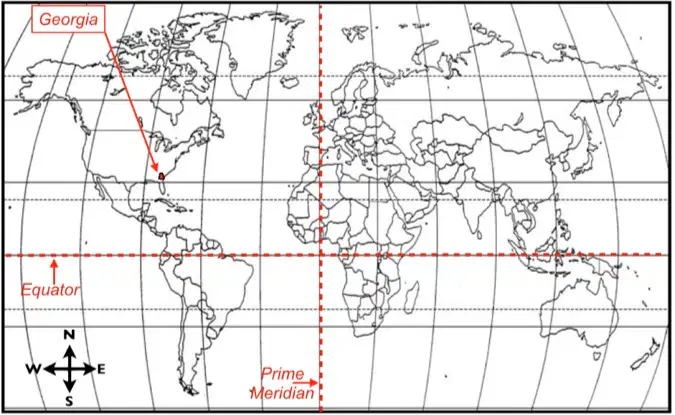
Georgia is located in both the ___ and ___ hemispheres.
Northern; Eastern
Southern; Western
Northern; Western
Southern; Eastern

