
 Worksheets
Southwest Asia Geography
Total questions: 51
Worksheet time: 51mins
The Gaza Strip and the West Bank are located in which country?
Israel
Iran
Iraq
Kuwait
Much of the world’s oil supply is shipped through which waterway?
Strait of Hormuz
Mississippi River
Nile River
Amazon River
Which river is the key water source for Israel, Lebanon, and Syria?
Jordan
Tigris
Euphrates
Nile
Are there any physical features countries might fight over? Why do you think they would do this?
Rivers - Water is scarce
Oil - It is worth a lot of money
Land boundaries- Some boundaries are much smaller than others

Label the physical features on the physical map below.
What is the physical feature labeled K?
Persian Gulf
Euphrates River
Gaza Strip
Atlantic Ocean

Label the physical features on the physical map below. What is the physical feature labeled L?
Suez Canal
Euphrates River
Strait of Hormuz
Red Sea

Label the physical features on the physical map below. What physical Feature is labeled M?
Tigris River
Euphrates River
Red Sea
Pacific Ocean

Label the physical features on the physical map below. What physical feature is labeled N?
Suez Canal
Red Sea
Euphrates River
Jordan River

Label the physical features on the physical map below. What physical feature is labeled O?
Atlantic Gulf
Persian Gulf
Red Sea
Jordan RIver

Label the physical features on the physical map below. What physical feature is labeled P?
Jordan River
Tigris River
Euphrates River
Red Sea

Label the physical features on the physical map below. What physical feature is labeled Q?
Strait of Hormuz
Red Sea
Arabian Sea
Dead Sea

Label the physical features on the physical map below. What physical feature is labeled R?
Strait of Hormuz
Euphrates River
Red Sea
Arabian Sea
· Much of the world’s oil supply is shipped through here
Red Sea
Strait of Hormuz
Dead Sea
Euphrates River
· Israel, Lebanon, Jordan, & Syria depend on this as their water source
Red Sea
Jordan River
Tigris River
Euphrates River
· Man-made waterway that connects the Mediterranean Sea to the Red Sea
Red Sea
Suez Canal
Persian Gulf
Jordan River
· An important trade route between India and Europe
Suez Canal
Arabian Sea
Strait of Hormuz
Persian Gulf
· Located between northeast Africa and SW Asia
Jordan River
Red Sea
Atlantic Ocean
Suez Canal
· Large supplies of the world’s oil can be found at the bottom
Suez Canal
Red Sea
Persian Gulf
TIgris River
· Begin in the mountains of Turkey and flow through Iraq
Red Sea
Tigris River
Euphrates River
Both b and c
Which country shares a border with Jordan and lies along the Mediterranean Sea?
Israel
Kuwait
Saudi Arabia
Turkey
Which country touches both the Red Sea and the Persian Gulf?
Israel
Kuwait
Saudi Arabia
Afghanistan
In order to reach the Persian Gulf from Iraq, through which country must you travel?
Kuwait
Turkey
Iran
Israel
Which country is east of Iran?
Afghanistan
Saudi Arabia
Israel
West Bank
The Gaza Strip and the West Bank are located in which country?
Israel
Iran
Iraq
Kuwait
What is the body of water between northeast Africa and Asia called?
Red Sea
Dead Sea
Black Sea
Yellow Sea
Are there any physical features countries might fight over? Why do you think they would do this?
Rivers - Water is scarce
Oil - It is worth a lot of money
Land boundaries- Some boundaries are much smaller than others
Which best describes the climate of much of Southwest Asia?
hot and dry
windy and cold
tropical and rainy
moderate and cool
The climate of Southwest Asia has led much of the region to experience a scarcity of ____.
trading
water
oil production
desalination plants
What is the 120-mile man-made waterway that is used to transport goods fro, the Red Sea to the Mediterranean Sea?
Gaza Strip
Suez Canal
Persian Gulf
Panama Canal
The Strait of Hormuz connects which bodies of water?
Red Sea & Arabian Sea
Mediterranean Sea & Persian Gulf
Mediterranean Sea & Red Sea
Persian Gulf & Arabian Sea
Why is the Suez Canal so important to international shipping?
It allows ships to get out of the Persian Gulf.
It connects the Jordan River to the Persian Gulf, making it cheaper to ship oil to other parts of Southwest Asia.
It makes it possible to get from the Mediterranean to the Red Sea without sailing around the Africa.
It is Iraq's only waterway to the Persian Gulf.
Which rivers flow through Turkey and Iraq?
Jordan and Tigris
Jordan and Euphrates
Tigris and Euphrates
Red and Jordan
What non-renewable natural resource has contributed to the growth of the Middle East?
oil
water
tiber
cotton

What sea is circled in red
Orange Sea
London Sea
Green Sea
Red sea

What sea is this?
Black Sea
Dark Sea
Arabian Sea

What gulf is this?
Persian Gulf
Arabian Sea
Red Sea

Which letter identifies the continent in which you would find the region of Southwest Asia (the Middle East)?
A
D
C
F

The Tigris and Euphrates Rivers flow south into the
Mediterranean Sea
Red Sea
Persian Gulf
Arabian Sea

Which letter identifies Saudi Arabia?
a
b
c
d
Iraq shares its southern border with with which two countries?
Iran & Jordan
Saudi Arabia & Kuwait
Syria & Turkey
Qatar & Yemen

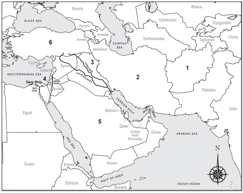
Which number represents Afghanistan?
7
8
3
1

Which number represents the Gaza Strip?
1
2
3
4
Which number represents Syria?
1
2
3
4

Which region is this?
West Bank
Gaza Strip
Golan Heights
Sinai Peninsula

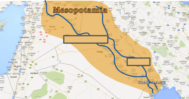
Name these two rivers, located in a region known as Mesopotamia.
Andes-Amazon
Danube-Volga
Tigris-Euphrates
Arabian-Iraqi

Which country touches both the Red Sea and the Persian Gulf?
Israel
Kuwait
Saudi Arabia
Afghanistan
The disputed territories of the West Bank and Gaza Strip are both located within _________.
Afghanistan
Israel
Kuwait
Turkey

