
 Worksheets
MM Unit 2 Review
Total questions: 54
Worksheet time: 33mins
Which of the following BEST explains the effect weather has on environment?
Annual precipitation levels
Average monthly temperatures vary widely in areas with the same latitude and physical features.
Weather is created by and impacts all four geospheres.
Weather and climate are impacted by the gravitational pull of the moon.
Which of the following forces explain the creation of mountains?
Hot spots
convergent
erosion
El Nino
Hawaii’s location in the center of the Pacific plate indicates the archipelago was created by -
Volcanic activity at hot spots.
Subduction zones near plate boundaries.
Wind erosion carrying rock particles
Transform activity along fault lines.
Which of the following best explains the appearance of the Canadian Shield?
Deposition of sediments has not occurred here.
Chemical weathering has killed the vegetation in the region.
It is a newly active tectonic region with exposed rock formations.
Glacial erosion removed the top soil.
Why is soil building a continual process?
Because new soil is needed for agriculture.
Because weathering and erosion never stop.
Because continental drift is always happening.
Because physical geography is static.
Which of the following is a direct effect of tectonic plate movement?
The physical topography of a mountainous region.
The average annual precipitation that an area receives
The distribution of biomes in an area
Seasonal changes in weather
Which pair best describes the physical process that caused its formation?
Hudson Bay and chemical weathering
Great Plains and erosion
Death Valley and asteroid impact
Appalachian Mountains and earthquakes
Climate characteristics are best described using -
Latitude and Longitude
Temperature and Precipitation
Weathering and Erosion
Atmosphere and Biosphere
Which current makes Western Europe habitable in comparison to other regions at the same latitude?
The Pacific Current
The Indian Ocean Current
The Gulf Stream
The Alaska Current
Because mountains force the prevailing winds to rise, causing condensation than precipitation, how does this impact climate distribution?
A Marine West Coast climate will be located on the leeward side of the mountains.
Arid climates are found on the leeward side of the mountains.
Semiarid climates are found on the windward side of the mountains.
A Tropical Wet and Dry climate will be located on the leeward side of the mountains.
The Leeward side of a mountain is the _____side; while the Windward side of a mountain is the ______ side.
Dry; Wet
Wet; Dry
Why does the windward side of a mountain have a wet climate?
Rising air compresses and warms, causing the water vapor to condense.
Rising air compresses and cools, causing the water droplets to evaporate
Rising air expands and warms, causing the water droplets to evaporate.
Rising air expands and cools, causing the water vapor to condense.
Which of the following physical features have been created by erosion?
Canadian Shield
The Great Lakes
Grand Canyon
Rocky Mountains
The warm climate zone near the equator:
Tropical Zone
Polar Zone
Temperate Zone
Climate
The cold climate zone near both poles:
Tropical Zone
Polar Zone
Temperate Zone
Climate
The area between the tropical and the polar zones with seasonal climate:
Tropical Zone
Polar Zone
Temperate Zone
Climate


The three climatic zones are formed because of the difference in...
Latitude
Altitude
Precipitations
All the options are correct
None of the options are correct
temperature depends on...
latitude
altitude
precipitation
climatic zone
Which of the following is NOT an effect of the tectonic plate?
Earthquake
Mountain building
Formation of valley
The temperature of the mantle
Convergent means "coming together". Divergent means...
to slide
moving apart
to move in a circle
vibrating
What are the three types of weathering?
mechanical, chemical, and biological
extinct, dormant, and active
core, mantle, and crust
convergent, divergent, and transform

What two crustal features occur near every subduction zone?
Volcanoes and Trenches
Rift Valleys and Mid Ocean Ridges
Volcanoes and Rift Valleys
Mid Ocean Ridges and Trenches
A divergent boundary on land creates what feature?
Mid Ocean Ridge
Rift Valley
Subduction Zone
Deep Ocean Trench
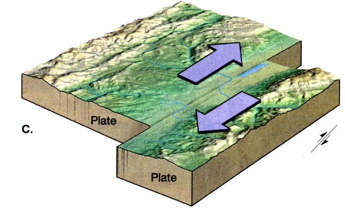

This type of Boundary results when plates separate
Divergent
Convergent
Transform
In surface currents, warm water moves towards the _______ and cold water moves towards the ________
Poles; Poles
Poles; Equator
Equator; Poles
Equator; Equator
Two coastal cities have the same latitude and elevation, but are located near different oceans. Which statement best explains why the two cities have different climates?
They have different longitudes
They are near different ocean currents
They have different angles of insolation.
They have different numbers of daylight hours.

The map shows the location of Virginia Beach, VA and Springfield, MO.
Virginia Beach experience cooler summers and warmer winters than Springfield because Virginia Beach
is located closer to the Atlantic Ocean
is located closer to the equator
has a greater average yearly duration of insolation
has a greater average yearly intensity of insolation
What is the name of the Wind Belt near the equator?
Easterlies
Trade Winds
Southerlies
Westerlies
What are prevailing winds?
Global winds that blow constantly but always change their direction
Global winds that blow constantly in the same direction
Global winds that always blow from East to West
Local winds that are really strong
What is the difference between Easterlies and Westerlies
Easterlies blow towards the East and Westerlies blow towards the West
Easterlies blow from the East and Westerlies blow from the West
Easterlies are winds that happen in the Spring around Easter and Westerlies happen in Autumn
Easterlies are all prevailing winds in the Northern Hemisphere and Westerlies are all prevailing winds in the Southern Hemisphere
What are ocean currents?
Large streams of air that flow above the ocean.
Large streams of water that flow through the ocean.
Global winds that blow constantly in the same direction
Local movement of water due to the tides
Warm currents
Help produce warm humid climates on the land they flow by
Help produce cool dry climates on the land they flow by
Always flow clockwise
Always flow North to South
Cold currents
Bring cold water from the poles to the equator
Bring warm water from the Equator to the poles
Always flow counter clockwise
Always flow South to North


1. This side of the mountain is dry and desert like because of the rain shadow effect.
Leeward
Sideward
Windward
Land

What landform causes the rain shadow effect?
Mountains
Lakes
Plains
Valleys

This side of the mountain is where the wind originates and evaporation occurs
windward
leeward
rain shadow
prevailing winds
During a(n) ____ event, trade winds are much stronger than usual.
El Nino
La Nina
Normal
Partly sunny
Both El Nino and La Nina have this in common
Influence birds that migrate over the ocean
Influence rainy / dry weather world wide
The weather at the polar regions
The directions that ships travel in the oceans

the BREAKDOWN of rock into smaller pieces of the same rock without any change in its composition

the part of the erosion process in which sediment travels to a new location and is laid down or DROPPED OFF


The process by which rocks are broken down
Weathering
Deposition
Erosion
Sedimentation

The process in which wind, water, ice or gravity move rock fragments from one location to another
Weathering
Sedimentation
Erosion
Deposition

The process in which sediment settles out (drops to the bottom) of the water or wind that is carrying it
Weathering
Erosion
Sedimentation
Deposition

