
 Worksheets
25/26 Unit 1 CSA Review
Total questions: 29
Worksheet time: 30mins
If you are facing North, which direction is to your right?
South
East
West
Northwest

Which state is Northwest of Texas?
New Mexico
Oklahoma
Louisiana
Arkansas
What state is West of Kansas
Colorado
Oklahoma
Missouri
Louisiana

What river starts near Canada and ends in the Gulf of Mexico?
Mississippi River
Colorado River
Rio Grande River
Hudson River
The ____________ is West of the United States. The _____________ is East of the United States.
Pacific Ocean / Atlantic Ocean
Atlantic Ocean / Pacific Ocean
Gulf of Mexico / Great Lakes
Great Lakes / Gulf of Mexico

In which grid square is the blue circle?
C2
D2
B3
B4
In which grid square is the "sun" shape?
B5
B4
B3
B4
Cardinal Directions
directions given by religious leaders
up, down, left, right
north, south, east, and west
give directions to natural resources
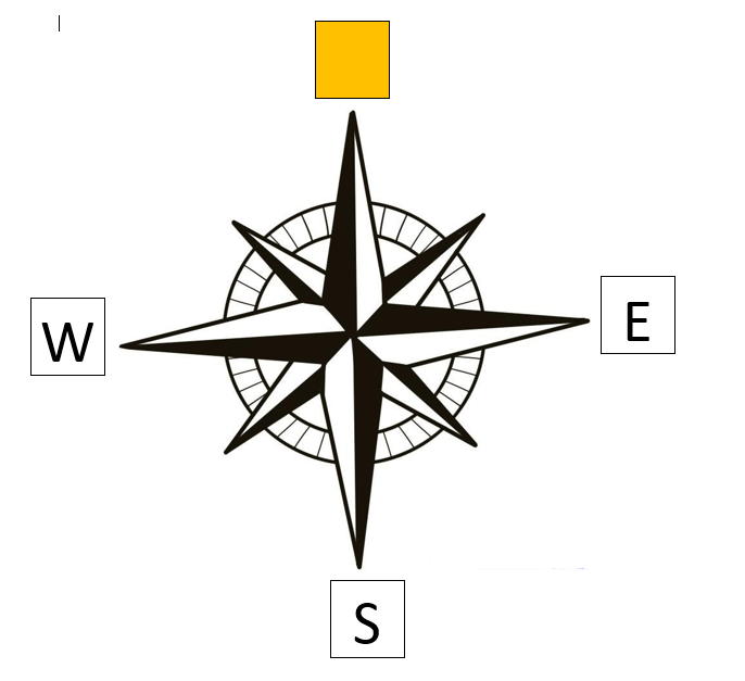
Which direction is missing?
North
East
Northwest
South
Northeast

Which direction is missing?
North
East
Southeast
South
Northeast

Which direction is missing?
North
East
Southeast
South
Southwest
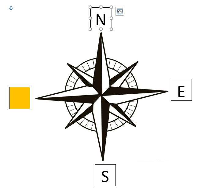
Which direction is missing?
West
Northwest
Southeast
South
Southwest

Which direction is missing?
North
Northwest
Southeast
Northeast
Southwest

Which direction is missing?
South
Northwest
Southeast
Northeast
Southwest

Which direction is missing?
West
Northwest
Southeast
Northeast
Southwest

Which direction is missing?
West
Northwest
North
Northeast
Southwest
Washington, Alaska, and Hawaii are located in what region?
Southwest
Midwest
Northeast
West

On the map the circles, triangles, and squares are all examples of:
Legends
Keys
Roses
Symbols

What is this an example of?
compass rose
physical map
map grid
map key

What tool would you use to measure the distance between two places on a map?
key
legend
scale
grid

The purple region is the __________ region
Northeast
Southwest
Midwest
West
The Yellow region is the __________ region
Northeast
Southwest
Midwest
West
The Green region is the __________ region
Northeast
Southeast
Midwest
West
The Red region is the __________ region
Northeast
Southeast
Midwest
West
The Orange region is the __________ region
Northeast
Southeast
Midwest
West

The Grand Canyon in Arizona is located in this region
Southwest
Northeast
Midwest
Southeast

Disney World in Florida is located in this region
Southeast
Midwest
Southwest
West

The Statue of Liberty in New York is located in this region
Northeast
Southeast
Midwest
Southwest
A region has certain industries because of the resources available in that region
True
False

