
 Worksheets
Physical Features and Countries of Europe.
Total questions: 15
Worksheet time: 7mins
Name
Class
Date
1.
Which peninsula is made up of the countries of Spain and Portugal?
a)
Italian
b)
Iberian
c)
Balkan
d)
Jutland
2.

What peninsula is shown in green?
a)
Jutland
b)
Iberian
c)
Swedish
d)
Scandinavian
3.

What mountain range is between France and Spain?
a)
Alps
b)
Pyrenees
c)
Apennines
4.

Which physical feature is pictured?
a)
Danube River
b)
Aral Sea
c)
Alps
d)
Pyrenees
5.

What physical feature is pictured?
a)
Danube River
b)
Aral Sea
c)
Alps Mountains
d)
Pyrenees
6.

What physical feature is pictured?
a)
Siberia
b)
Baltic Sea
c)
Ural Mountains
d)
Lake Baikal
7.

Which physical feature is pictured?
a)
North Sea
b)
Volga River
c)
Rhine River
d)
Strait of Gibraltar
8.
What peninsula is shown in green?
a)
Jutland
b)
Iberian
c)
Swedish
d)
Scandinavian
9.

What body of water is shown in blue?
a)
English Channel
b)
Mediterranean Sea
c)
Black Sea
d)
Red Sea
10.

What body of water is shown in blue?
a)
English Channel
b)
Mediterranean Sea
c)
Rhine River
d)
Danube River
11.

What country is located at number one?
a)
France
b)
Germany
c)
Russia
d)
Spain
12.

Which country is number 2?
a)
Germany
b)
United Kingdom
c)
France
d)
Italy
13.

What country is highlighted?
a)
Portugal
b)
Italy
c)
Austria
d)
Germany
14.

What country is highlighted?
a)
Iceland
b)
United Kingdom
c)
Austria
d)
Germany
15.
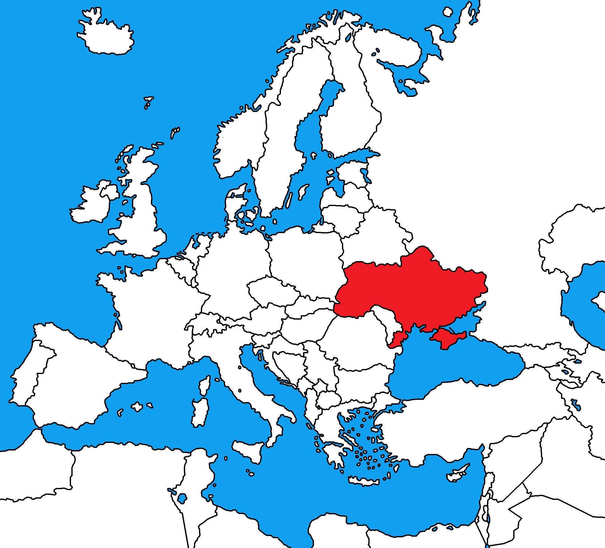
What country is this?
a)
Poland
b)
Russia
c)
Turkey
d)
Ukraine
100 %

