
 Worksheets
CA 2 density, weather maps, plates
Total questions: 62
Worksheet time: 2hrs 4mins

Near which two cities are the low pressure systems located?
Seattle & San Francisco
Chicago & Seattle
Dallas & Houston
Chicago & Nashville

Near which city is the high pressure system located?
Seattle
Minneapolis
Dallas
Chicago

Which two cities are most likely to experience clear, dry weather?
Seattle & San Francisco
Chicago & Minneapolis
Chicago & Nashville
Dallas & Houston
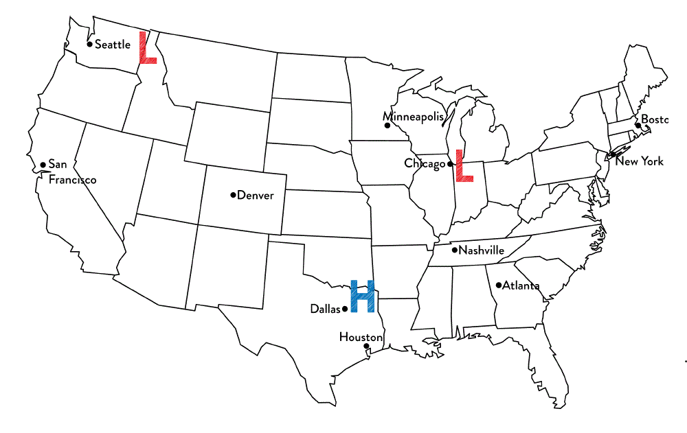
Tim said that Chicago is most likely to experience rainy weather. Jennifer thinks that Dallas is most likely to experience rainy weather.
Which student is correct?
Tim because Chicago is the closest to a low pressure system and they produce precipitation.
Jennifer because high pressure systems produce precipitation
Both students are correct because all systems produce precipitation
Neither of the students are correct because the cities are not close enough to the system.

These symbols represent a/an ________
cold front
warm front
stationary front
occluded front

When this symbol is present on a weather map, it represents
a cold air mass has taken over a warm air mass
a warm air mass has taken over a cold air mass
a cold air mass and warm air mass meet but neither have enough force to move each other
two cold fronts have collided and a warm air mass is pushing it upwards

When this symbol is present on a weather map, it represents
a cold air mass has taken over a warm air mass
a warm air mass has taken over a cold air mass
the sun is rising
a hurricane is going to occur

What type of weather is generally associated with a low pressure system?
fair-weather, beautiful clear skies
Cloudy skies, some moist air, possible precipitation, stormy weather
cloudy skies, dry air
cloudy with a chance of meatballs

What type of weather is associated with a high pressure system?
clear skies & moist air
cloudy skies & dry air
cloudy skies & moist air
clear skies & dry air

Which location is most likely experiencing warmer temperatures and higher humidity?
Location A
Location B
Location C
Location D


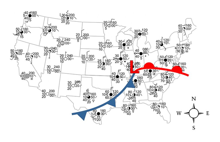
What direction is the warm front moving on the map?
North
South
East
West


Why does city "B" have clear skies?
It is in North America
There is not a front moving through city "B"
Clouds do not form in the West
It is located near a high pressure system


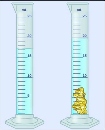
10.0 ml
15.0 ml
20.0 ml
25.0 ml

18.0 ml
6.0 ml
38.0 ml
An object has a volume of 6 cm3 and a mass of 42 g. What's it's density?
7 g/cm3
48 g/cm3
42 g/cm3
6 g/cm3


Which geologic feature/event would most likely be found at a divergent boundary between two pieces of oceanic crust?
Which geologic feature/event would most likely be found at a transform boundary?
Which geologic feature/event would most likely be found at a divergent boundary between two pieces of continental crust?

What two crustal features occur near every subduction zone?
Volcanoes and Trenches
Rift Valleys and Mid Ocean Ridges
Volcanoes and Rift Valleys
Mid Ocean Ridges and Trenches

What type of boundary is this?
Convergent
Divergent
Transform

What type of boundary is this?
Convergent
Divergent
Transform

What type of boundary is this?
Convergent
Divergent
Transform

Tectonic Plate movement is caused by ______________.
the rotation of the Earth
ocean tides
convection currents in the mantle
the moon's gravity

What type of boundary is this?
Divergent
Convergent
Transform
What was Wegener’s continental drift idea?
The continents have moved slowly apart to their current locations.
The continents have always been located at their current locations.
The continents are moving slowly together from their current locations.
None of these
True or False-Similar fossil records across continents was evidence for continental drift.
True
False
True or False-The continents including the continental margins can be pieced together to form a single whole continent.
True
False
True or False-The magnetic polarity evidence indicates that there were two north magnetic poles in the geologic past.
True
False
Alfred Wegener named his single supercontinent ____________, which means "all Earth" in ancient Greek.
Pandora
Gandowandaland
Pangaea
Percia

What is the force that moves the continents?
Conduction
Convection
Radiation
Conveyor belts
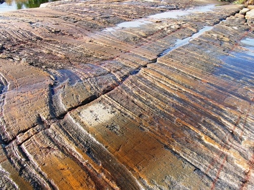
Scientists recently discovered that rocks collected from the Franklin Mountains in West Tests and rocks collected from mountains in eastern Antarctica were exactly the same age. Further research showed that the rocks were chemically and geologically the same and came from the same magma source. This discovery provides evidence of--
coastal erosion
plate tectonics
ocean currents
glacial melting
A mid-ocean RIDGE is located at the boundary of two tectonic plates. Which diagram correctly models the relative plate motion on each side of a mid ocean ridge?


The San Andreas fault is a transform fault. The map below shows a student's approximation of where the fault line crosses through the United States. Students were asked to make maps predicting which way land would most likely move over thousands of years.


The map shows the locations of four active volcanoes in the Caribbean Sea. What do these volcanoes indicate about plate tectonics in the region?
The volcanoes form an island arc, indicating a converging plate boundary
The volcanoes form a line, indicating a diverging plate boundary.
Two plates are moving past each other, causing faulting and magma formation.
Two plates are moving apart, creating new seafloor

The model below shows two continental plates. The folded mountains in this model form at which type of plate boundary?
Transform boundary
Divergent boundary
Subduction boundary
Convergent boundary
A hurricane is a large, rotating storm system that forms over water, bringing high winds, rough seas, and heavy rain. Hurricanes occur where
ocean water is the warmest, near the equator in the late summer.
ocean water is the coolest, near the pole in the late winter.
the ocean has extremely high tides.
the ocean has extremely low tides.

The map represents a satellite image of Hurricane Gilbert in the Gulf of Mexico. Each ‘X’ represents the position of the center of the storm on the date indicated.
Why did Hurricane Gilbert weaken between September 16 and September 18?
The hurricane changed into an anti-cyclone.
The hurricane season ended in mid-September.
The hurricane lost its source of warm ocean water.
The pressure gradient within the hurricane increased.
One of the major ways oceans contribute to weather systems is that the oceans -
provide a diverse habitat for many organisms.
store and transport the Sun’s heat energy.
experience changes in amounts of dissolved salt.
reach depths that can be as much as 12,000 meters.
Which of the following factors contributes most to formation of hurricanes?
gravitational pull of the moon and sun
toxic chemicals in the atmosphere by industry
Glaciers melting in polar regions
solar radiation heating the oceans by equator
Where does the Storm Start?
Over Cold Water
Over Antarctica
Over Warm Water
Overseas
What are ways to slow down a hurricane?
Warm water touching land
Cool water and touching land
Cool water and staying in the ocean
Warm water and staying in the ocean
Earth maintains constant average temperatures within its lands, oceans and atmosphere. What is the best explanation for these constant average temperatures?
Earth's Hemisphere has opposite seasons
Earth is tilted and rotates daily on its axis
Global weather systems generally move from west to east
The continuous motion of air and water distribute the sun's energy
If the sun heated all parts of the earth evenly, how would it affect the oceans?
Thermal energy would be transferred from the equator to the poles
convection currents related to differences in temperature would disappear
the speed of global winds would decrease, slowing the currents
more water would sink to the ocean floor

