
NEW
Font size
 Worksheets
Map Skills Grade 4
Total questions: 36
Worksheet time: 18mins

What direction is missing?
north
south
east
west

A 3D sphere that shows a map of the earth is called a...
globe
continent
country
ball
Which of the following is NOT a cardinal direction?
north
south
over there
west
Why do people need maps?
To learn how to spell.
So they can find a prize.
To help them find their way.
So they can have nice things.
A compass rose is placed on a map in order to show
Elevation
Scale
Direction
Climate
Used to measure distance on a map


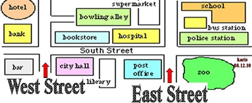
What is the special saying
we use to remember the cardinal
directions?
even swans nest Wednesdays
never eat soggy waffles
we never end school
every night we sing

In what direction do we go to get from the zoo from the hotel?
The Earth is in the shape of a____________.
five
equator
sphere
square
How many oceans are there on Earth?
seven
five
four
latitude
The NORTHERNMOST part of the Earth is called the _______________.
North Pole
South Pole
longitude
equator
The SOUTHERNMOST part of the Earth is called the _________________.
South Pole
North Pole
latitude
Southern
Imaginary lines that run horizontal (side to side) across the Earth are known as lines of _______________.
longitude
latitude
sphere
equator
Imaginary lines that run vertical (up and down) across Earth are known as lines of
latitude
longitude
equator
Prime Meridian
The line of latitude that stretches across the middle of Earth is called the ________________________.
equator
Prime Meridian
longitude
latitude
The line of longitude that stretches across the middle of Earth is called the______________.
equator
Prime Meridian
longitude
latitude
The Earth has _________ hemispheres.
6
5
7
4
The land ABOVE the equator is the _____________hemisphere.
Southern
Northern
North Pole
South Pole
The land BELOW the equator is the ____________ hemisphere.
Southern
Northern
North Pole
South Pole
The scale shows
symbols on the map.
cardinal directions on the map.
distance on the map.
none of the above.
The compass rose shows cardinal directions on a map.
TRUE
FALSE
The legend or map key helps you understand
the symbols on the map.
the cardinal directions.
the distance on the map.
Cardinal directions are
up, down, left & right.
north, south, east & west.
under, over, in between & after.
before, after, next & last

Where can you find out what symbols mean on a map?
The credits
The legend or key
The compass rose
You can't find it anywhere

The pirates hid the treasure in this grid: ____
B4
C4
D2
D3

What is the symbol for the national capital on this map?


A tool that shows north, east, south, west on a map is called _______.
Legend or Key
Scale
Compass Rose
Title
A map is used to show continents, countries, states, streets and more.
True
False

Is this statement true or false? The red arrow is pointing to the map key.
True
False
What is geography
The study of the Earth and its surfaces.
The study of the population
Longitude and Latitude
A kind of map
Vegetation is
Plants that grow in an area
The landforms in an area
Climate is
daily weather in an area
weather patterns that happen over a long period of time
How hot or cold a place is
A region is
An area that is grouped together due to similar characteristics
e.g. We live in the NorthEastern region of the US
Areas that are grouped together but do not have any common characteristics
A political map
shows that the landforms look like
shows how many people live in an area
uses colors to show borders of cities, towns countries, etc
A physical map
shows that the landforms look like and where they are located
shows how many people live in an area
uses colors to show borders of cities, towns countries, etc

