
NEW
Font size
 Worksheets
Earth Science Review Quizziz
Total questions: 23
Worksheet time: 8mins
The magnitude of an earthquake is measured by an instrument called
a digital scale
a seismogram
a seismograph
kilogram
The further the seismic waves travel from the center, the ____________ they become.
Stronger
Weaker
What is the difference between the epicenter and the focus?
The epicenter is located on Earth's surface and the focus is on the fault line.
The focus is located on Earth's surface and the epicenter is on the fault line.
Where is an earthquake the strongest?
Epicenter
Fault
Focus
The type of crust that is under the world's oceans.
CONTINENTAL
OCEANIC
This type of crust is described as denser and heavier
CONTINENTAL
OCEANIC
Thicker and older part of the Earth's crust
CONTINENTAL
OCEANIC
Two plates come together or collide at what boundary?
Convergent
Divergent
Transform
Which of the following is formed at Continent- Continent convergent boundaries?
Volcanic Mountains
Earthquakes
Non-volcanic Mountain Ranges
Both volcanoes and earthquakes
Why does subduction occur?
Old crust is more dense and gravity helps pull the crust back into the mantle.
Old crust is less dense and it sinks back into the mantle.
Old crust is warm and melts back into the mantle.
Old crust has no where else to go but through trenches.


The movement of the tectonic plates is caused by
the rotation of the Earth.
convection currents in the Asthenosphere
the gravity of the iron-nickel core.
the Moho discontinuity.
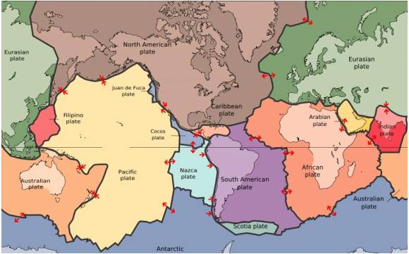
The map in the picture shows tectonic plate boundaries. This map would be useful in predicting the location of future
droughts
hurricanes
earthquakes
tornadoes
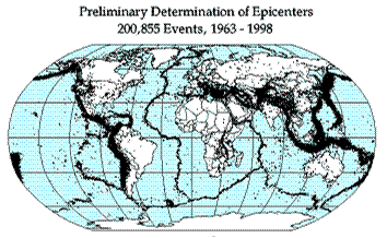
Earthquake epicenters (center of where the earthquakes started) were mapped for a 35 year period in the diagram above. The black dots indicate these epicenters. The black dots appear along what feature on Earth?
hot spots
plate boundaries
rift zones
sea floor spreading
The 2004 Indian Ocean tsunami was caused by a shift in two plates that pushed one section of the sea floor under another section of the sea floor by 5 meters. What type of boundary is this?
divergent
convergent
transform
metamorphic
The middle layer of the earth that makes up most of the earth’s mass is the
Mantle
crust
core
Geology

