
 Worksheets
Water Cycle, Weather, Landforms
Total questions: 30
Worksheet time: 24mins

Which action os most likely happening in section Y in the diagram?
Wind and rain compacting rock into larger pieces
Water carrying rocky material to a new location
Chemicals in water gluing sediments to each other
Pressure causing layers of sediment to form over time

What process more likely caused for this rock to crack?
Water freezing and thawing in the rock
Wind blowing particles against the rock
Water moving and dropping the rock
Glaciers scraping over the surface of the rock
Which Texas land formation is correctly paired with the force that made the land formation?
A canyon at Palo Duro Canyon State Park was formed by a river.
A sand dune at Monahans Sandhills State Park was formed by an earthquake
A delta at the end of the Guadalupe River was formed by wind.
A rock formation with layers on Mustang Island was formed by ice.
Which of the following explains how water undergoes a change of state in one stage of the water cycle in order to move from the ocean’s surface into the air?
Liquid water that is heated by the sun becomes a gas and rises.
Gaseous water rises as it is cooled by the ocean.
Liquid water that is heated by the sun condenses into rain.
Gaseous water collects in drops of fog above the ocean’s surface.
(a) is the conditions of the atmosphere over a long period of time.
(a) is the measurement of the atmosphere on a given day.
Which statement correctly describes how a landform is formed?
A lake is formed when flowing water carves out the sides of a canyon.
A mountain range is formed when glaciers slowly move across the landscape.
A delta is formed at the mouth of a river when flowing water slows and deposits sediment.
A U-shaped valley is formed when winds pick up and move sediment away from the landscape.

Which process does this diagram most likely represent?
The erosion of a coastline
The deposition of sediments
The weathering of a mountain
The formation of a sea
Which landform is a result of rapid changes to Earth’s surface?
U-shaped valley
Limestone cave
Mountain range
Volcanic island
Which table correctly classifies statements about weather and climate?


Which statement best describes the processes of weathering and erosion?
Weathering and erosion are directly responsible for the breakdown of any type of rock into smaller particles and the carrying away of the loose sediments.
Weathering and erosion are directly responsible for depositing loose sediments on the bottom of the ocean, forming layers of sediment.
Weathering and erosion are directly responsible for the amount of water in a river that transports sediments to the sea.
Weathering and erosion are directly responsible for the transportation, deposition, and compaction of loose sediments on the seafloor.
Sand dunes are created through the process of (a) and the agent that caused this was (b)
The kinds of data that reflect climate are different from the conditions described in weather data. Which of the following is a description of climate?
Today it is hot and sunny in Phoenix, Arizona.
Summers are usually mild in Lansing, Michigan.
Last week it rained every day in San Antonio, Texas.
Yesterday was cold and windy in Anchorage, Alaska.

What could the title of this table be?
Climate Report for Old Dime Box, TX
Average Temperatures for Old Dime Box, TX
Weather Report for Old Dime Box, TX
Precipitation Report for Old Dime Box, TX

What question could students answer after reading this map?
What is the temperature in Alaska?
What is the climate for the majority of the U.S.?
What is the difference in population of the Northern hemisphere compared to the Southern hemisphere?
Which city has the most rainfall for the month of September?

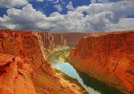
This landform is formed by
water erosion
wind erosion
deposition
glaciers
Glaciers are masses of ice that move slowly on land. Which of these features was most likely formed by a glacier?
A wide valley
A deep ocean
A lava flow
A mountain range
Hills formed by wind blowing, moving and depositing sand.
Valley
Dune
Delta
Canyon
The movement of sediment down a fast-moving river.
Weathering
Erosion
Deposition
River

What agent of change causes a sand dune?
Water
Wind
Ice

What agent of change causes a U-shaped Valley?
Water
Wind
Ice

What agent of change caused the SEA arch?
Water
Mud
Glacier

What agent of change causes a canyon?
Water
Wind
Ice
During condensation, water turns into ________.

Which one shows a picture of condensation?


Which one shows a picture of evaporation?

