
 Worksheets
OS Maps Part 1
Total questions: 70
Worksheet time: 36mins
What four things are needed to make a good map?
Title, Key, North arrow, Scale
Scale, Symbols, North Arrow, Title
North arrow, Symbols, Title, Key
Symbols, Title, North arrow, blue lines
What does OS stand for?
Original Scale
Ordinance Survey
Ordnance Survey
Optional Scale

What is this symbol?
Picnic site
Camp site
Shop
Play area

What is this symbol?
Solar panels
Viewpoint
Camp site
Farm
Scale helps us to measure what?
(a)
Which of the following does not need to be included in a good map?
Key
North arrow
Place names
Scale bar
What is missing: North, South, West
(a)
A map that is 1:50000 means the features are reduced/made smaller by how much?
5000
5500
55000
50000

Identify the OS map symbol.
Coniferous Wood
Non-coniferous Wood
Mixed Wood


when contours are very close to each other
it means the land is flat
it means the land is gentle
it means the land is steep
it means it is a hill
when contours are far from each other
it shows the land is steep
lt shows the land is gentle
it shows the land is flat
l

What is the contour interval on the image?
10
20
30
40
which of the following is not a scale of OS maps
1: 15000
1:25000
1:50000

This contours and picture show a
steep slope
gentle slope
hill
cliff

The contours (Western part) and image show a
steep slope
gentle slope
flat land
hill

The image and contours show
a hill
a valley (gully)
a gentle slope
Which two are the correct order of compass points?
North-West-East-South
South-West-North-East
East-West-South-North
North-East-South-West

The red line on the map is called
prime meridian
equator
tropic of cancer
tropic of capricorn

Name continent 1
Africa
Europe
Asia
Australia
Americas
Name continent 2
Africa
Europe
Asia
Australia
Americas
Name continent 4
Africa
Europe
Asia
Australia
Americas
Name the ocean to the west of contintent 2
Indian
Pacific
Atlantic
Name continent 1
Africa
Europe
Asia
Australia
Americas
Which of the following is not a way to tell the height on maps?
contours
grid references
spot heights
trigonometric points
The distance between contour lines is known as
Lines
Interval
Interval lines
Contours intervals

The contour interval
20m
60m
10m
5m

How many peaks are on the map? (hill tops)
4
3
2
1

What is the elevation at Position A?
1600
1500
20
240

What is the elevation at position B?
1500
1600
20
240

Is point A at the bottom or the top of the hill?
Bottom
Top

Match the topographic map to its profile picture.


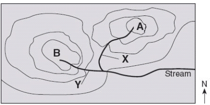
Which direction is the stream flowing?
northward
southward
westward
eastward

Match 4
C
D
E
F

Match 2
B
C
D
E

Match 1
A
B
C
D

The image shows a topographic map.
Which statement best describes the location marked by the X?
It is at the bottom of a large pit.
It is at the top of a hill.
It is on the side of a mountain.
It is in a deep cave.

Which line represents the steeper slope?
Line A
Line B
Line C
Lines that show areas that have the same elevation
Aging Lines
Check Out Lines
Contour Lines
Waiting Lines

Identify the symbol
Railway station
Roundabout
Bus stop
Traffic lights

Identify the symbol
Building of historic interest
Hotel
School
Hospital

Identify the symbol
Dance School
Recreation/Leisure/Sports Centre
Steep Cliff
Bungee Jumping

Identify the symbol
Metro
Mountain
Museum
Mill

Identify the symbol
Sword Shop
Fencing
Pirate Warning
Site of Historic Battle

Identify the symbol
Castle/Fort
Broken Tower
Manor House
Monastery

Identify the symbol
Duck Shop
Nature Reserve
Bird-Watching Zone
Petting Zoo

Identify the symbol
Cycle Trail
Bike Shop
Motorbike Race Track
Free Bicycle Parking

Identify the symbol
Telephone
Apple Store
Police Station
Information Centre

Identify the symbol
Pokemon
Petrol
Parking
Pizza Shop

Identify the symbol
Place of worship with a spire, minaret or dome
Place of worship with a tower
Place of worship
Sword in the stone

Identify the symbol
Youth Hostel
Hotel
Pyramid
Bed and Breakfast

Identify the symbol
Quarry
Waterfall
Beach
BMX Track

Identify the symbol
Coniferous Trees
Non-Coniferous Trees

What is the golden rule for finding a Grid Reference?
Never eat soggy Weet-a-Bix.
Along the corridor, then up the stairs.
Along the pathway, and through the gate.
Eastings before bee-stings.


What would you find at 566169?
Campsite
Public House
Farm
Bridge

What is at F2?
Mountains
River
Treasure
Lake

What is the grid reference for car park?
What are the reference numbers that appear first in a grid reference?
Northings
Eastlings
Northlings
Eastings
Who does NOT use a grid reference while working?
pilot
driver
cook
travellers

What is the missing number at the end of this grid reference for the church 24....?
00
01
02
03

What is the location of blue lagoon lake?
D1
D3
A5
A1

What is the 4-figure GR for the letter B?
1531
1432
1530
1431

What is the 4-figure GR for the letter D?
3117
173317
1731
1832


What feature is found at grid reference 015793?
Campsite
Railway station
School
Church

What is the 6 figure grid reference for the school?
(a)

