
 Worksheets
Unit 6 & 7 World Geography SCA
Total questions: 23
Worksheet time: 19mins
A type of graph that combines bar and line graphs showing monthly averages of precipitation and temperatures for an area is known as a
Climatype
Climagraph
Weather map
Temperature pyramid
How do the Ural Mountains affect the distribution of climate regions in Russia?
The northern side of the mountain range receives cool, rainy weather, while the southern side is a hot desert.
The western side of the mountain range receives warm continental winds, while the eastern side is much cooler and drier.
The western side receives cold, arctic weather, while the eastern side is protected from weather extremes and has a mild climate.
The western side of the mountain range receives warm Mediterranean winds, while the eastern side is affected by Indian Ocean monsoon rains.
The taiga is a biome best known for which type of climate?
Temperate winter seasons with high aridity
Cooler summer seasons with tropical humidity
Long winter seasons with low temperatures
Low rainfall in extended summer seasons
Why is a location on the ocean often a good place for a new settlement?
It provides water and natural resources as well as transportation opportunities
It is a safer location for a settlement
It is a location with a high elevation
It is not susceptible to harsh weather

Using both the map of China and the map of the U.S., what comparison of the capital cities can be made?
Both are located with easy access to an ocean.
Both are approximately the same size.
Both are centrally located in their countries.
Both are the largest cities in their countries.
Which is a cultural pattern of contemporary Russia that distinguishes it from its communist roots?
Russian law prohibits organized religion.
Russians have a new celebration like the Day of the Dead.
Russian law prohibits European emigration.
Russians have a new social class of wealthy business people.
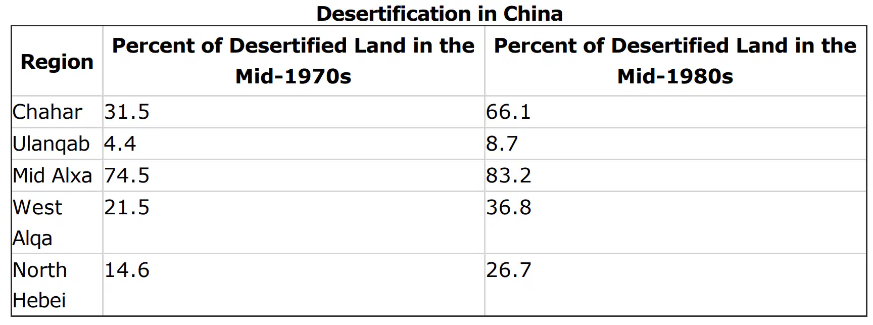
What conclusion can you draw from the table above about the deserts in these five Chinese regions?
They are slowly shrinking.
They have stayed the same.
They are rapidly expanding.
They have doubled in size.
Which of the following explains how a decrease in elevation affects climate?
Temperature decreases
Precipitation and temperature increase
Air pressure and wind speeds decrease
Temperature increases
One cultural trait of Russia is its love of the ballet. Both the work of as an international ballet star in the late 1900s symbolize this. Which words BEST complete the paragraph?
Anton Chekhov…Peter Tchaikovsky
Peter Tchaikovsky...Leo Tolstoy
Peter Tchaikovsky…Mikhail Baryshnikov
Mikhail Baryshnikov…Anton Chekhov
Which of the following continents is probably broken into the MOST culture regions?
North America
South America
Europe
Asia
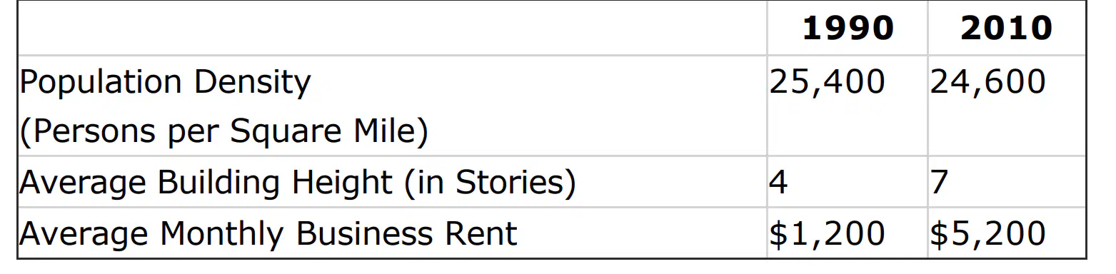
Use the table below to answer the question. This table compares the same urban neighborhood during two time periods. The changes shown in this neighborhood reflect which phenomenon?
The formation of small communities based on economic class
The shift in economic function from commercial to industrial
The process of gentrification resulting from demographic shifts
The reduction of sprawl due to land-use controls
All of the following are the result of drought conditions EXCEPT
Soil loss
Dust storms
Wind erosion
Dune formation
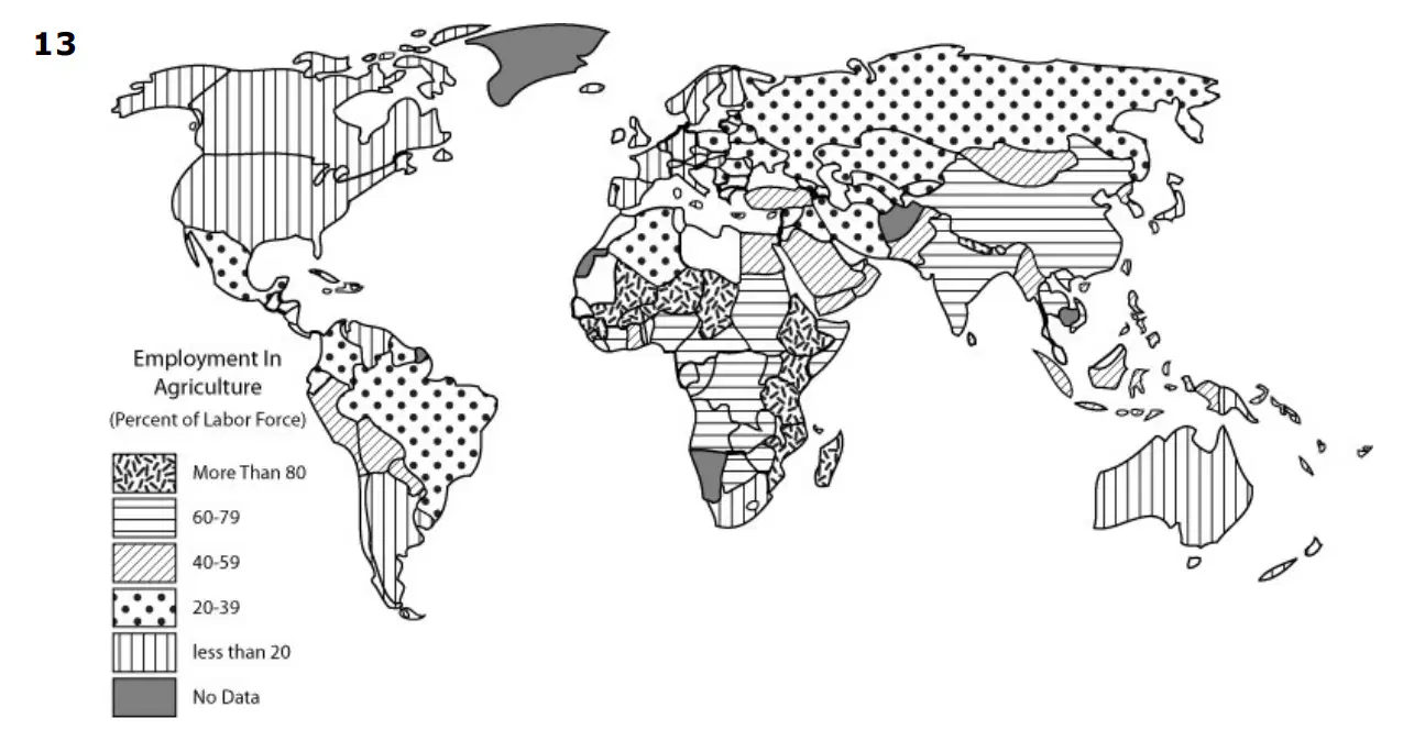
The percentage of the population involved in specific activities determines the level of economic development of a nation. Those economic activities are designated as primary, secondary, tertiary, and quaternary. In a primary economy much of the population is dependent on use of the land, e.g., farming, mining, fishing, and hunting. In a secondary economy, much of the population is involved in manufacturing. This includes taking any products of the land and creating another product, e.g., grinding grain into flour. A tertiary economy has a large percentage of its population in the services sector. This includes sales, maintenance, and repair work. Finally, quaternary societies have citizens working at computers with information processing. Adapted from Human Geography, R.E. Nelson, et. al.
Using the map and reading above, which of the following would NOT be an indicator of advanced economic development?
Large supplies of mined ores
Multiple forms of transportation
High energy consumption
Sophisticated communications
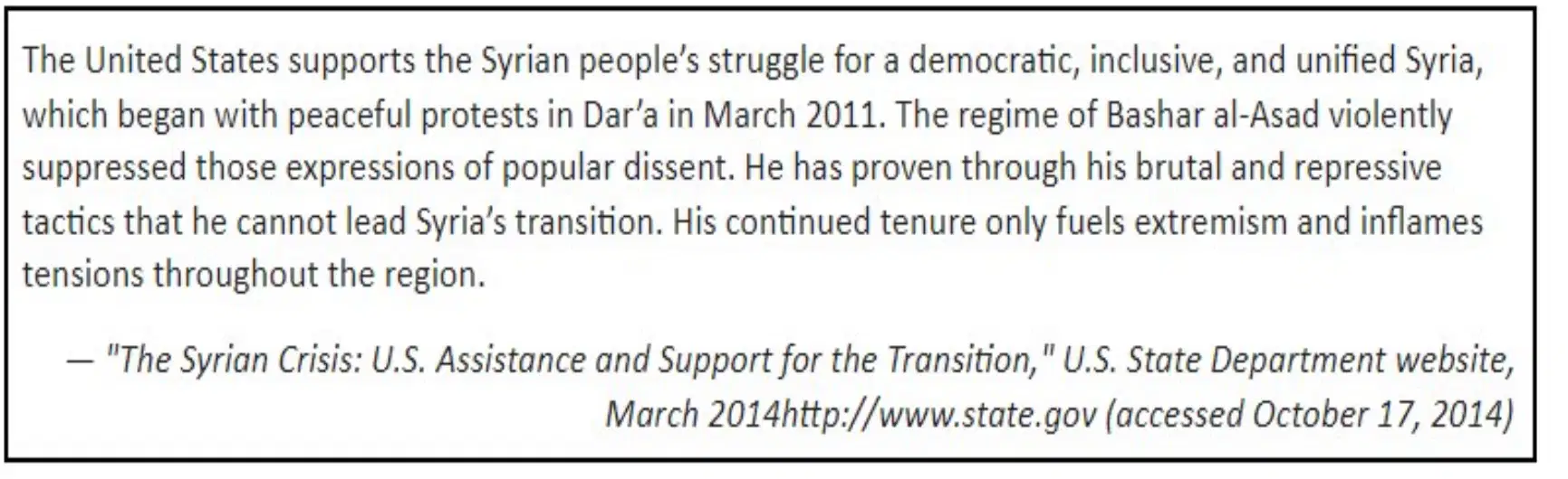
Based on the information in the excerpt, the United States’ government has attributed the cause of the conflict in Syria to
The violent behaviors of the dissident crowds.
The authoritarian policies of the Syrian government.
The spread of tension throughout Southwest Asia.
the lack of cohesion among the protesting groups.
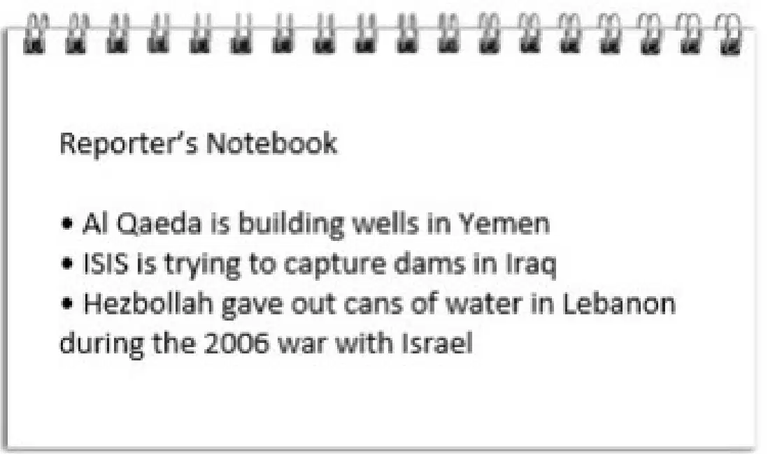
Which title below best summarizes the news story being investigated?
Funding for Desalination Needed
Lack of Water Empowers Extremists
Middle East Drying Up Before Our Eyes
Climate change Leads to Regional Conflicts
Which event is a daily reminder in Southwest Asia of the significance of religion in the region?
Ramadan dinners
Public calls to prayer
Pilgrimages to Mecca
Friday store closings

The creation of the organization described in the excerpt has affected Southwest Asia by
Encouraging revolutionaries in the region to overthrow dictators.
Increasing conflict in the region as nations battle over setting oil prices.
Calling for embargos that have decreased oil exports in the region.
strengthening the global influence of the oil producing nations of the region.
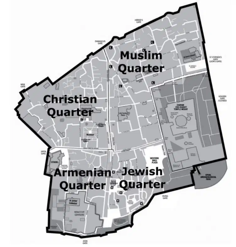
Based on the map, one way that cultural diffusion has impacted the city of Jerusalem includes
The creation of separate distinct cultural enclaves.
the blending of several religious traditions into a new one.
the building of a wall to keep threatening forces out of the city.
the division of the city into Palestinian and Israeli administered areas.
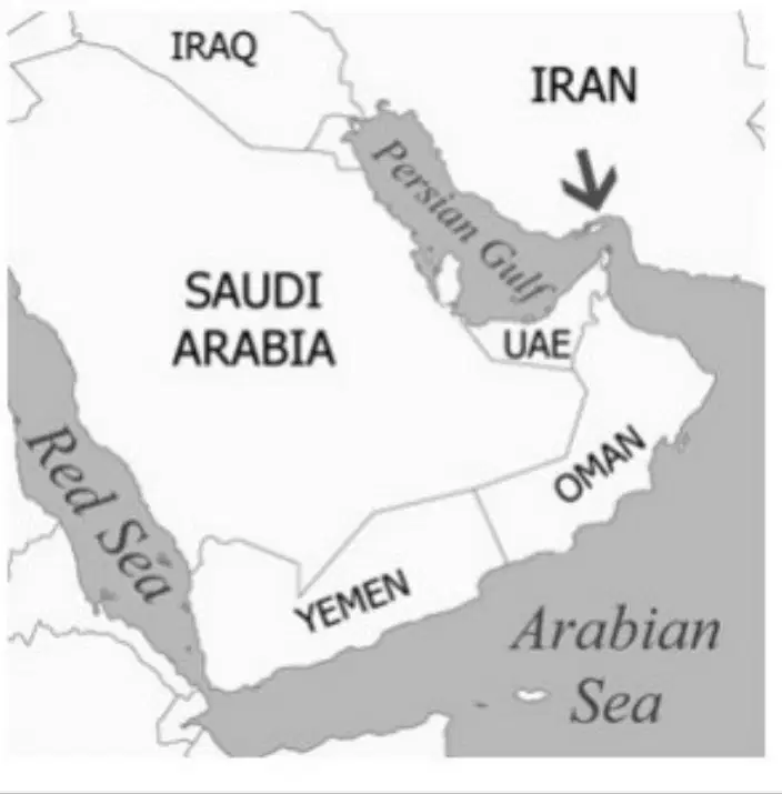
The strait indicated by the arrow on the map is one of the busiest shipping lanes in the world. What type of maritime traffic accounts for a majority of this activity?
Oil Tankers
Cruise ships
Ferry boats
Naval destroyers
The arid and semi-arid climate of much of Southwest Asia creates biomes that are characterized by
taiga and tundra.
temperate forests.
tropical rainforests.
grasslands and desert.
A distinct feature of the cultural landscape in many towns located in Southwest Asia includes
shipyards
sports stadiums.
skyscrapers.
shopping bazaars.
How does the spatial diffusion of Islam compare to that of Christianity?
Islamic leaders faced fewer physical geographic barriers than did Christian missionaries.
Both originated in Southwest Asia yet Christianity spread from the region to dominate in Europe.
Christian missionaries arrived in North Africa after Muslim leaders had conquered the territory.
Most Christians living in Southwest Asia today migrated to the region after the formation of Israel.
Many societies in Southwest Asia have adapted to the scarcity of water in this region by
constructing levees and canals.
creating policies to fine individuals who waste water.
building desalinization facilities.
converting dams to produce water rather than electricity.

