
Font size
 Worksheets
Middle East and North Africa Test Review
Total questions: 30
Worksheet time: 16mins
What inferences can be drawn about the effects of oil reserves and their locations in places like Dubai and Bahrain?
Dubai and Bahrain have become international centers of business and finance
Dubai and Bahrain have become underprivileged nations
Dubai and Bahrain have a declining GDP
Dubai and Bahrain have an increased need for better education
What impact has technology had on the economy of the Persian Gulf region?
Technology has no impact in the Persian Gulf region, oil production is not affected
Technology has increased available land and decreased oil production
Technology has improved, but there is no increase in oil production
Technology has improved the ability of the Persian Gulf region to increase oil production

Based on the map, what can be concluded about natural resources in the Persian Gulf?
There is a lack of energy resources and petroleum should be imported
Many of Saudi Arabia’s resources are found in its interior
Energy resources found along the coast suggest a large export market
There are huge deposits of copper found in the region

Based on this map, what are the most abundant natural resources found along the Persian Gulf?
Petroleum and Natural gas
Copper and Lead
Lead and Petroleum
Natural gas and Lead

Based on this map, which chokepoint and region receives the most oil from southwest Asia?
Panama Canal exporting to North America
Strait of Malacca exporting to Australia
Bab el-Mandeb and the Mediterranean
Strait of Hormuz exporting to South East Asia
Workers migrate to the Arabian Peninsula because of push factors such as ______ in their home countries.
Tax-Free Government
Abundance of Food
Statewide Education
High Unemployment

Which chokepoint is the easiest path for North African Migrants to enter the Middle East?
Strait of Straits
Panama Canal
Strait of Hormuz
Suez Canal
Which of the following do NOT cause desertification?
Overgrazing of Grasslands
Desalination Process
Prevailing Winds Bringing High Moisture
Extreme Flooding
Using the paragraph below and your knowledge of geography, answer the following question.
"Situated between Africa, Asia, and Europe, the Middle East has been a crossroads for traders, travelers, and empire builders for thousands of years. Africans, Central Asians, and Celts have all added to the ethnic mix. Major ethnic groups in the Middle East today include Arabs, Iranians (also known as Persians), Turks, Jews, Kurds, Berbers, Armenians, and Greeks."
What conclusion can be drawn regarding cultural diffusion in the Middle East?
People in the Middle East remain sedentary because of trade
Trade influenced what people in the Middle East eat, speak, and believe
Trade influenced only a small portion of people in the Middle East and not much was gained
Trade influenced only the music of Middle Eastern people

Based on this graph above, what interpretation can be drawn about job opportunities in 2016 because of OPEC?
Non-OPEC countries contributed to over 25% of the world's oil reserves and created more jobs than OPEC
OPEC countries contributed less than 75% to oil reserves depleting job opportunities in the Middle East
OPEC countries did not have to increase job opportunities because of low production in crude oil reserves, which caused emigration to happen at staggering rates
OPEC countries contributed over 80% of the world's crude oil reserves, increased job opportunities to meet the needs of demands, and led to increased immigration

Based on this chart, which countries below provided the most barrels of oil from greatest to least?
Saudi Arabia, Ecuador, Gabon, Venezuela
Kuwait, Saudi Arabia, United Arab Emirates, Gabon
Iraq, Nigeria, Angola, Equatorial Guinea
Qatar, Angola, Algeria, Ecuador

Based on this image, what is the main motive for the Israeli-Palestinian conflict?
Territorial/border disputes
The Holocaust
Disagreements over economic systems
Religious persecution
What is a technological solution the Middle East is using to try and combat water scarcity?
Importing water from other countries
Desalination
Creating water from its component atoms
Creating manmade lakes
What is one of the main factors that has led to water scarcity in the Middle East?
Conflict in the region has led to a destruction of water resources
Overconsumption has led to a lack of water
The region has a hot arid climate with little yearly rainfall
Pollution in the region has led to a lack of drinkable water

Based on this map, what is most likely the main language spoken in the Middle East?
English
Arabic
Hebrew
Aramaic
In order to better control the annual flooding of the Nile River, the Egyptian government built what structure?
Suez Canal
Aswan High Dam
Ataturk Dam
Hoover Dam

Based on this map, what can account for the massive differences in development in the region?
A lack of military conflict
Oil Exportation
Strict Laws
An abundance of water
What is an effect Islam has had on the modern world?
Advances in science and math, such as the creation of algebra
The diffusion of Arabic as the main language of the US
The use of the Quran in hotel rooms
The many famous paintings of the prophet Muhammad
This system segregated Africans according to their race, giving white Africans the majority of the power.
Imperialism
Kafala
Cultural Assimilation
Apartheid

How did the Berlin conference affect the continent of Africa?
Allowed for the Exportation of Natural Resources to Europe and the US
Allowed Africa to Create Alliances in Europe
Created Unity Between The US and Asia
Decreased Gold Production in South Africa
The Middle East is one of the only places in the world where this form of government still exists.
Constitutional Monarchy
Democracy
Theocracy
Absolute Monarchy
The ________ River in North Africa is the longest river in the world
Nile
Red
Dead
Amazon
Jews and Arabs have been in conflict for many years regarding territory in the Israel area. This conflict has centered around which major city?
Mecca
Cairo
Jerusalem
Dubai

Groups of people who have been forced to flee their homes due to conflict, war, or natural disasters are referred to as what?
Nomads
Refugees
Citizens
Kurds
The Middle East contains the world's saltiest body of water known as:
Dead Sea
Red Sea
Black Sea
Skeleton Sea
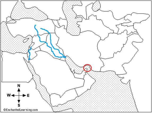
The most important natural chokepoint in the region circled on this map is called what?
Suez Canal
Mediterranean Sea
Tigris River
Strait of Hormuz
The main difference between an Oasis and a Wadi is that an Oasis is a mostly ______ source of water, and a Wadi is mostly ______
Temporary, Permanent
Permanent, Temporary
Stagnant, Moving
Moving, Stagnant

Name these two rivers, located in a region known as the fertile crescent.
Andes-Amazon
Danube-Volga
Arabian-Iraqi
Tigris-Euphrates
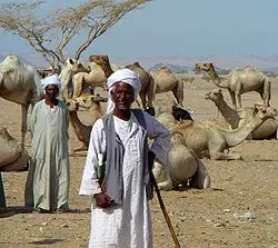
Groups of people who live in different locations, moving from one place to another are called
caravans
oases
nomads
normals
What is one reason why desalination plants are not more common in other parts of the world that suffer from water shortages?
Those countries have other methods to obtain clean water
Desalination is an expensive process that is not feasible for those areas
Desalination does not produce enough water to justify building a new plant
The people in those regions have adapted to drinking dirty water

