
NEW
Font size
 Worksheets
3rd NIne Weeks Social Studies Review
Total questions: 28
Worksheet time: 14mins
Why do many states in the southeast of the United States, like Florida and South Carolina, have planned evacuation routes?
The southeast does not have very many people.
The southeast often freezes during the winter.
The southeast does not have any highways.
The southeast is often hit by dangerous storms.
What do many scientists believe has caused the melting of the polar ice caps?
natural cycles
military conflicts
human pollution
decreased temperatures
Historically, why did Europeans want to trade with Asian civilizations?
Europeans refused to sell products to other nations on the same continent.
Europeans did not know how transport goods across the ocean.
Asian civilizations had natural resources Europeans wanted.
Asian civilizations had democratic governments that were similar to the Europeans'.

This is a quote from a public announcement system used in Oklahoma.
According to this quote, why is this public announcement system needed in Oklahoma?
The region often deals with earthquakes.
The region often deals with tsunamis.
The region often deals with blizzards and ice storms.
The region often deals with storms and tornadoes.
What is one way that weather can impact the population of a region?
A region where droughts are common is heavily populated.
A region that often floods is usually not very populated.
A region where farming is easy is not very populated.
A region where tornadoes are common is heavily populated.
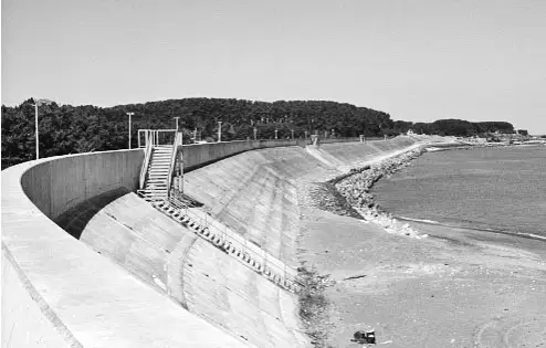
This is a photograph of a part of the coast of Japan.
Based on this photograph, how have Japanese people adapted to the unique geography of their country?
They have built large canals to protect against drought.
They have created new landmasses to protect against overpopulation.
They have created windfarms to protect against pollution.
They have built large walls to protect against tsunamis.
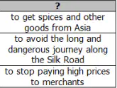
What would be a good title for this chart?
New Technology for Exploration
Reasons for Exploration of the Seas
Ways to get Goods from Asia
Rules for Trading with Africa
How do historians believe humans crossed the Landbridge to migrate to North America?
They built special boats to sail across the ocean.
They walked across when the ocean froze, and the sea level dropped.
They used large animals to pull boats across the ocean.
They swam across to follow animal herds.
How did the astrolabe and the compass advance exploration of the world?
They helped the ships move faster in the water.
They allowed the ships to move against the wind.
They used the stars to make it possible for ships to travel at night.
They showed the ship's location and direction making navigation easier.
How did competition between European nations inspire the exploration of the New World?
Nations wanted to stop depending on trade with Asia.
Nations wanted to become more powerful than other nations.
Nations wanted to weaken the Catholic Church.
Nations wanted to increase the power of Native Americans.
How did the development of the caravel impact European exploration of the New World?
It made travel faster.
It made maps more accurate.
It made navigation easier.
It made ships larger.
Why did Portugal seek an all-water route to Asia?
to spread Christianity
to learn Buddhism
to gain wealth through faster trade
to gain territories through war
How did technology impact European exploration of the New World?
New technologies weakened the power of European monarchs.
New technologies decreased interest in exploring the New World.
New technologies made sea travel faster and safer.
New technologies decreased the importance of international trade.
Which European explorer is best known for creating the settlement that would become Charleston, South Carolina?
Juan Pardo
Jean Ribault
Hernando de Soto
Henry Woodward
Why did Juan Pardo try to create a good relationship with the Native Americans of South Carolina?
He wanted to protect their lands.
He wanted to join their tribes.
He believed they could be strong trading partners.
He believed they would become good slaves.
What was Henry Hudson looking for when he was exploring the New York area?
a new way to Australia
a new passage to China
a new route around the world
a connection between the Atlantic and Pacific Oceans
What did Hernando DeSoto find on his explorations?
He was the first to make it to California.
He was the first to find the Great Lakes.
He was the first to cross the Mississippi River.
He was the first to find Canada.

Which historical event best completes this chart?
African Slave Trade
European Exploration of the New World
Declaration of Independence
Sectionalism in the United States
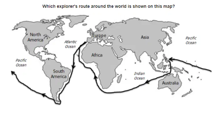
Which explorer's route around the world is shown on this map?
Christopher Columbus
Hernando de Soto
Ferdinand Magellan
Henry Hudson
Which explorer claimed much of eastern Canada for France?
Jacques Cartier
Christopher Columbus
Ferdinand Magellan
Amerigo Vespucci
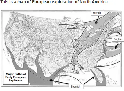
How did the exploration routes of North America differ?
Responses
The Spanish explored mostly in the West, while the French explored mostly in the Southwest.
The English explored mostly in the Northeast, while the Spanish explored mostly in the South and Southwest.
The French mostly explored in the West, while the Spanish explored mostly in the South and Southwest.
The English explored mostly in the South, while the Spanish explored mostly in the Northeast.
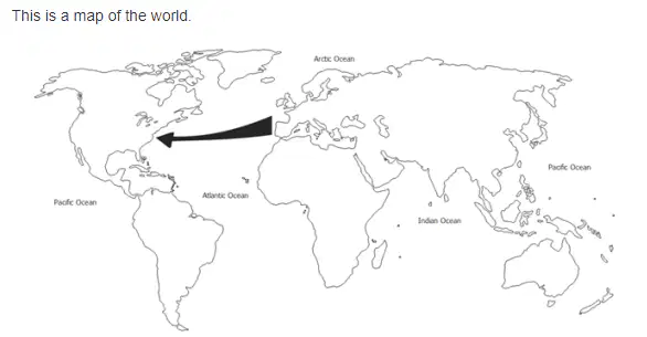
The arrow on the map shows what?
the route between Africa and South America
the route between Africa and Australia
the route between South America and Australia
the route between Europe and America
Which European explorer do most historians believe to be the first to sail to North America?
Hernando de Soto
Leif Eriksson
Robert LaSalle
Ferdinand Magellan
How did the explorations of Christopher Columbus impact European history?
They began the colonization of North America.
They began the colonization of Africa.
They brought deadly diseases to Europe.
hey brought European governments closer to democracy.
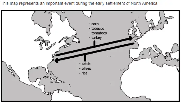
What important event does this map demonstrate?
Columbian Contributions
Columbian Exchange
Columbian Expeditions
Columbian Trading
Which nation is responsible for setting up Charles Town, the first permanent settlement in South Carolina?
England
France
Portugal
Spain
How did the European exploration of North America have a negative impact on Native Americans?
New diseases destroyed much of the Native American population.
New farming techniques increased the Native American population.
New ideas about land ownership led to alliances.
New religions challenged tradition.
Which settlement was allowed the most self-government by its mother country?
Jamestown
New Netherland
New Spain
Quebec

