
 Worksheets
Term 1 Geo Quiz
Total questions: 23
Worksheet time: 22mins

Equator
Prime Meridian
International Date Line
North Pole


cups
gallons
degrees
Fahrenheit

Equator
Prime Meridian
International Date Line
North Pole
The equator divides the Earth into what two hemispheres?
Eastern and Southern
Northern and Southern
Western and Eastern
Northern and Western
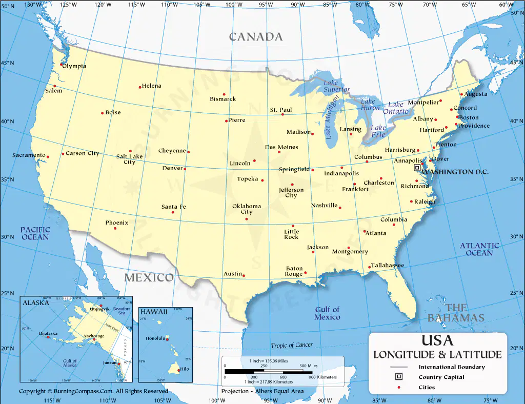
On the Map of the USA, what is the coordinates for the city of Sante Fe?
36°N 107°W
36°S 107°W
39°N 117°W
46°N 17°W
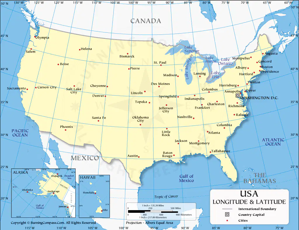
On the Map of the USA, what is the coordinates for the city of Helena?
47°N 112°W
47°W 112°N
47°S 112°E
47°N 112°S
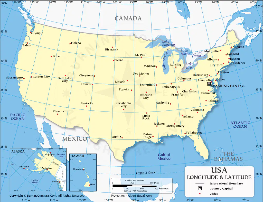
On the map of the USA, what does 1 inch = in km?
250
300
217.89
135.39

On the map of the USA, which two countries share a border with the USA?
Alaska + Hawaii
Canada + Mexico
Alaska + Canada
Hawaii + Mexico
What is the Capital of the USA according to the printed map?
New York
Washington D.C
Springfield
Austin
On your printed map of the USA, if 1 cm = 260km, how far is it in km from Carson City on the West Coast to Atlanta on the East Coast?
14.8cm
3246km
4030km
12.3cm
On your printed map of the USA, if 1 cm = 260km, how far is it in km from St. Paul to Austin?
2158km
2540km
2450km
2504km
Which hemisphere is the USA in? Write only ONE of the following: Northern, Eastern, Southern, Western. Spelling DOES count
(a)
Is the USA above or below the equator?
Above
Below
True or False: you can drive to a beach on the Indian ocean of you live in the USA?
False
True
A scale is?
An instrument that shows directions
The shape and features of land area
The shape and features of land area
The relationship (or ratio) between distance on a map and the corresponding distance on the ground
The equator and the prime meridian measures
2 degrees
1 degree
0 degree
What kind of map will show me the provinces in South Africa?
Physical
Climate
Economic/Product or Resource
Political
One characteristic of a Physical Map is that it...
shows the different climates in the world
show important natural, physical features, such as mountains, elevations, rivers, vegetation, forests and lakes.
show how people have divided up the earth's surface
show how many people live in an area
A map has a scale of 1cm = 4km.
The actual distance between two cities is 52km, what is the distance between the two cities on the map?
208cm
13cm
2.08cm
13miles

