
NEW
Font size
 Worksheets
Year 9 Geography Skills BHS
Total questions: 51
Worksheet time: 25mins
The basic elements or feature of any map contains
S.C.R.E.W.S
B.O.L.T.S.
B.L.O.T.E.
SOMETHING
The 'O' in B.O.L.T.S. stands for
nOrth
Orienteer
Orient
Orientation

What is this called?
map scale
map key
compass rose
a dial

Add the missing elements
North East
East South
South West
North West
North East
South East
South West
North West
North East
North West
East South
East West
East North
East South
South West
North West

what is this?
compass rose
a map legend
a map key
a map scale

what is this?
map scale
map key
compass rose
shows boundaries of states, continents, countries, counties
Topographic
Weather
Satellite
Political
Graphs need to have:
B.O.L.T.S.
A title and numbers
A title, a scale and labels
A title, a scale, labels and numbers
A climate graph is the combination of:
A column graph and a line graph
A column graph and a pie chart
A line graph and a pie chart
A proportional graph and a column graph
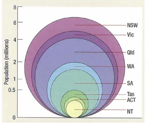
What type of graph is this?
Climatic Graph
Proportional Graph
Demographic Graph
Pie Graph
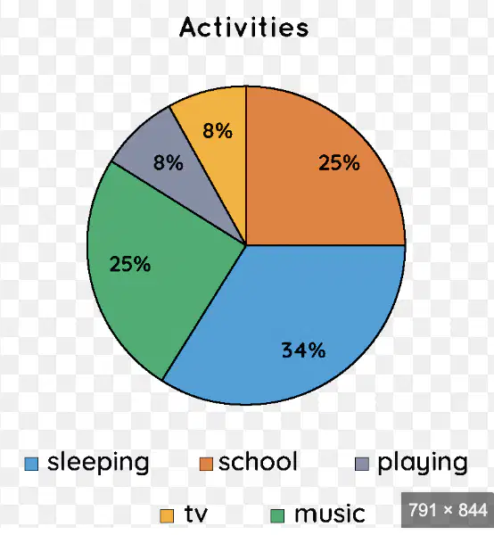
Which activities take the same amount of time each day?
School and Sleeping
School and playing
Music and TV
Playing and TV
Which activity takes the most amount of time per day?
School
Sleeping
Music
Playing

Which month has the highest rainfall of the year in the UK in 2018?
January
July
June
November
Which is the hottest month of the year in the UK in 2018?
January
July
June
November

Which continent has the largest urban population according to this pie chart?
Africa
Europe
South America
Asia

The red line seen here is called the...
latitude
tropic of cancer
equalator
equator

The lines on the globe are called ________ and ________?
North, East, South West
latitude and longitude
Equator, tropic of cancer, tropic of capricorn
Coordinates and location
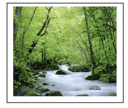
This type of image is known as ...
vertical image
horizontal image
eye level image
ground level image

This view is called a ...
Oblique image
Satellite image
Horizontal Image
Vertical Image

This view is called a ...
Oblique image
Satellite image
Horizontal Image
Vertical Image
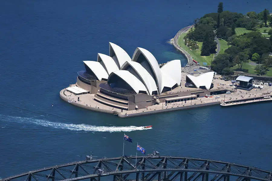
This view is called a ...
Oblique image
Satellite image
Horizontal Image
Vertical Image
The process of showing the spherical Earth on a piece of paper is called a...
Protector
Projection
Promotion
Politician

What type of map is this?
Choropleth Map
Chromatic Map
Barometric Map
Weather Map

Earthquakes, tsunamis and volcanic eruptions, are examples of...
natural disasters
mother nature attacks
natural accidents
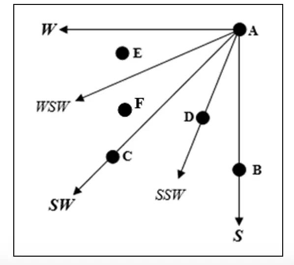
If travelling from B to A you are going in what direction?
South
North
West
East
If travelling from A to C you are going in what direction?
South
South, South West
South West
West South West
Area Reference (AR) refers to a whole square and 4 numbers. These numbers are recorded from
The top left corner
The top right corner
The bottom right corner
The bottom left corner
When writing the Area Reference, your write the
Eastings first, then southlings
Northings then southlings
Northings then Eastings
Eastings then Northings
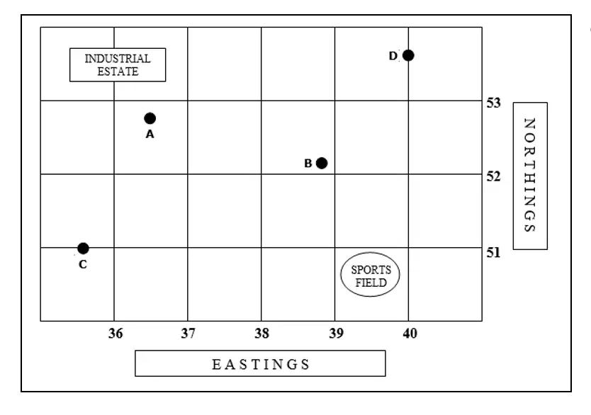
A is located at AR:
3752
3653
3652
3753
Grid Reference (AR) refers to a specific place in a square and has how many numbers?
2
4
6
8
A is located at GR
375527
365527
365357
375537
A ratio scale is actually called a
linear scale
fraction
ratio fraction
Representative fraction

This scale is called:
Representative fraction
Linear scale
Ratio scale
Scale
Latitude and Longitude
Latitude is horizontal and Longitude is vertical
Latitude is vertical and Longitude is horizontal
When calculating co-ordinates,
Latitude is always done first
Longitude is always done first
Lines drawn on a map to indicate height above sea level (a.s.l.) are called
Aspect
Relief
Contour lines
Gradient

What is the height difference between each line?
20m
5m
60m
10m
What is the relief at point B?
20m
5m
60m
10m
What does 'aspect' refer to?
the difference in height between two points on a map
a term for steepness of a slope
the direction that the orientation faces
the direction that a slope faces

Aspect refers to the direction that a slope faces.
If I was standing on that slope at point A, facing downhill, in which direction would I be looking?”
North
South
East
West
Which statement is the MOST correct?
Density refers to
the number of specific features in a given area
the number of buildings in a specific area
the number of trees in a specific area
the number of people in a specific area
The area reference of 4216 has:
1 building per km2
3 buildings per km2
5 buildings per km2
7 buildings per km2
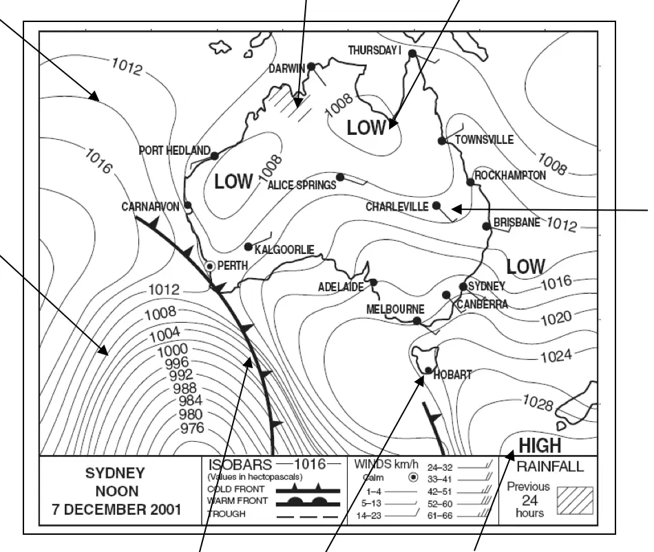
The lines drawn that join places of equal air pressure are called:
hectopascals
barometric pressure
hPa
Isobars
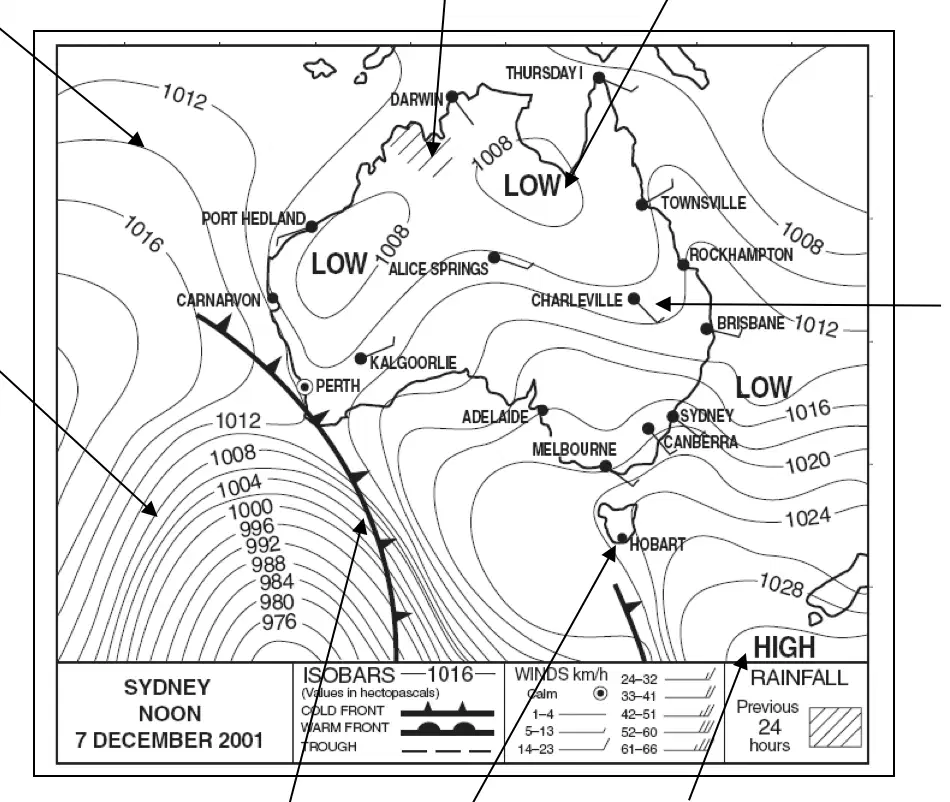
Cold Front: This is where moving cooler
air meets warmer air.
Cold fronts cause changes to weather, including:
Cooler temperatures; increased chance of rain/storms
Higher wind speeds / possible direction change
Generally cold & unstable conditions until the
front passes
All of the above
High Pressure system: . .
Air moves in an anti- clockwise direction
Also known as an anti-cyclone
Often shown simply as H
All of the above
Which state has received rainfall in the past 24 hours?
Queensland
Western Australia
Tasmania
South Australia
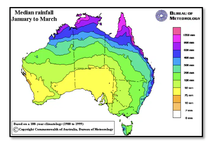
What type of map is this?
Precis
Choropleth
Political
Cadastral
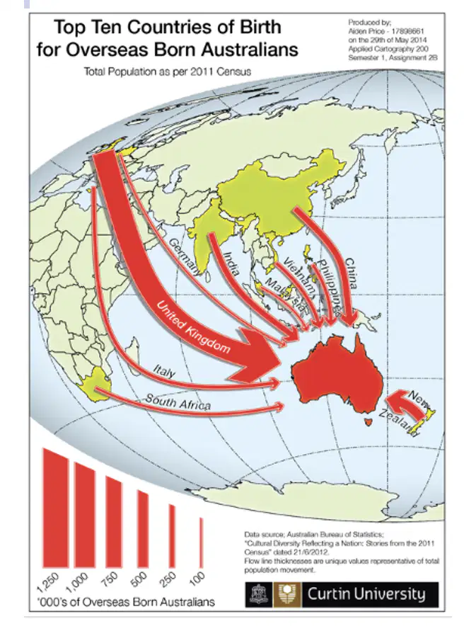
This is a Flowline map. They are designed to show
flow
wind direction
movement
themes
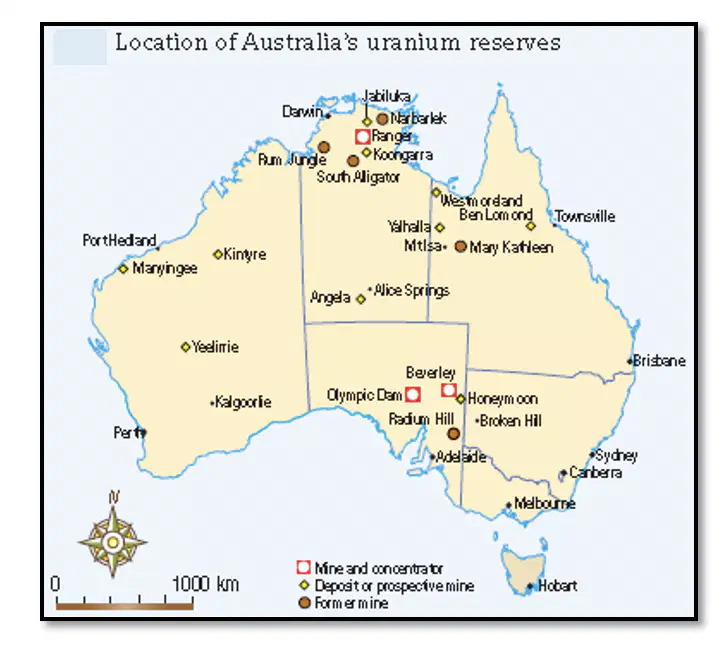
This is a thematic map, which illustrates a particular theme.
What does this map show?
Former mines
mine and concentration levels
prospective mines
Location of Australian uranium reserves

