
 Worksheets
Unit 4 Reviw
Total questions: 23
Worksheet time: 12mins
Which of the following parts of the Earth may act like a liquid?
¿Cuál de las siguientes partes de la Tierra puede actuar como un líquido?
کدام یک از قسمت های زیر زمین ممکن است مانند مایع عمل کند؟
inner core
núcleo central
هسته داخلی
crust
corteza
پوسته
outer core
núcleo externo
هسته بیرونی
mantle
manto
مانتو
From least to most dense, what is the correct order of Earth's four major layers?
De menos a más densa, ¿cuál es el orden correcto de las cuatro capas principales de la Tierra?
ترتیب صحیح چهار لایه اصلی زمین از کمترین تا متراکمترین آنها چیست؟
crust, outer core, inner core, mantle
corteza, núcleo externo, núcleo interno, manto
کورتزا، نوکلئو خارجی، نوکلئو اینترنو، مانتو
inner core, outer core, mantle, crust
núcleo interno, núcleo externo, manto, corteza
هسته داخلی، هسته بیرونی، گوشته، پوسته
crust, mantle, outer core, inner core
corteza, manto, núcleo externo, núcleo interno
پوسته، گوشته، هسته بیرونی، هسته داخلی
mantle, inner core, outer core, and crust
manto, núcleo interno, núcleo externo y corteza
گوشته، هسته داخلی، هسته بیرونی و پوسته
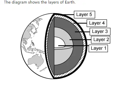
Which statement best describes Layer 3 and Layer 5?
¿Qué afirmación describe mejor la capa 3 y la capa 5?
کدام عبارت لایه 3 و لایه 5 را بهتر توصیف می کند؟
Layer 3 is the crust and Layer 5 is the mantle; both layers are hotter than Layer 1.
la Capa 3 es la corteza y la Capa 5 es el manto; ambas capas son más calientes que la capa 1.
لایه 3 پوسته و لایه 5 گوشته است. هر دو لایه گرمتر از لایه 1 هستند.
Layer 3 is the mantle and Layer 5 is the crust; both layers are hotter than Layer 1.
la Capa 3 es el manto y la Capa 5 es la corteza; ambas capas son más calientes que la capa 1.
لایه 3 گوشته و لایه 5 پوسته است. هر دو لایه گرمتر از لایه 1 هستند.
Layer 3 is the mantle and Layer 5 is the crust; both layers are cooler than Layer 1.
la Capa 3 es el manto y la Capa 5 es la corteza; ambas capas son más frías que la capa 1.
لایه 3 گوشته و لایه 5 پوسته است. هر دو لایه سردتر از لایه 1 هستند.
Layer 3 is the crust and Layer 5 is the mantle; both layers are cooler than Layer 1.
la Capa 3 es la corteza y la Capa 5 es el manto; ambas capas son más frías que la capa 1.
لایه 3 پوسته و لایه 5 گوشته است. هر دو لایه سردتر از لایه 1 هستند.
Which of the following properties of minerals is described with the Mohs scale?
¿Cuál de las siguientes propiedades de los minerales se describe con la escala de Mohs?
کدام یک از خواص مواد معدنی زیر با مقیاس Mohs توصیف شده است؟
luster
lustre
درخشش
fracture
fractura
شکستگی
fluorescence
fluorescencia
فلورسانس
hardness
dureza
سختی
Ms. Johnson is teaching her students the differences between rocks and minerals. Which table should Ms. Johnson use to best show the differences?
La Sra. Johnson está enseñando a sus alumnos las diferencias entre rocas y minerales. ¿Qué tabla debería usar la Sra. Johnson para mostrar mejor las diferencias?
خانم جانسون در حال آموزش تفاوت بین سنگ ها و کانی ها به شاگردانش است. خانم جانسون باید از کدام جدول برای نشان دادن بهترین تفاوتها استفاده کند؟


Bread is made by mixing flour, water, and yeast together and then baking. How does the example of bread tell the difference between rocks and minerals?
El pan se hace mezclando harina, agua y levadura y luego horneando. ¿Cómo el ejemplo del pan muestra la diferencia entre rocas y minerales?
نان از مخلوط کردن آرد، آب و مخمر با هم و سپس پختن تهیه می شود. چگونه مثال نان تفاوت بین سنگ ها و مواد معدنی را نشان می دهد؟
The bread would be a mineral. The flour, water, and yeast would be rocks.
El pan sería un mineral. La harina, el agua y la levadura serían rocas.
نان یک ماده معدنی خواهد بود. آرد، آب و مخمر سنگ خواهد بود.
The bread, flour, water, and yeast would all be rocks.
El pan, la harina, el agua y la levadura serían rocas.
نان، آرد، آب و مخمر همه سنگ خواهند بود.
The bread would be a rock. The flour, water, and yeast would be minerals.
El pan sería una roca. La harina, el agua y la levadura serían minerales.
نان سنگ می شد. آرد، آب و مخمر مواد معدنی خواهند بود.
The bread, flour, water, and yeast would all be minerals.
El pan, la harina, el agua y la levadura serían todos minerales.
نان، آرد، آب و مخمر همه مواد معدنی خواهند بود.
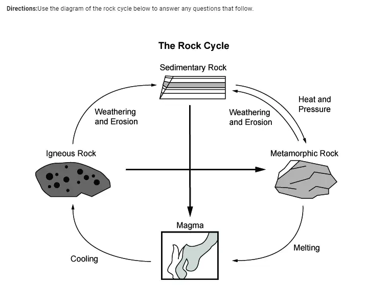
Igneous rock is formed from cooling magma. Which process will change igneous rock into sedimentary rock?
La roca ígnea se forma a partir del enfriamiento del magma. ¿Qué proceso cambiará la roca ígnea en roca sedimentaria?
سنگ آذرین از سرد شدن ماگما به وجود می آید. کدام فرآیند سنگ آذرین را به سنگ رسوبی تبدیل می کند؟
heat and pressure
calor y presión
گرما و فشار
melting
derritiendo
ذوب شدن
cooling
enfriamiento
خنک کننده
weathering and erosion
desgaste y erosión
هوازدگی و فرسایش
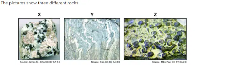
Which table correctly matches the rocks with their correct type and process of formation?
¿Qué tabla relaciona correctamente las rocas con su tipo y proceso de formación correctos?
کدام جدول به درستی سنگ ها را با نوع درست و روند تشکیل آنها مطابقت می دهد؟


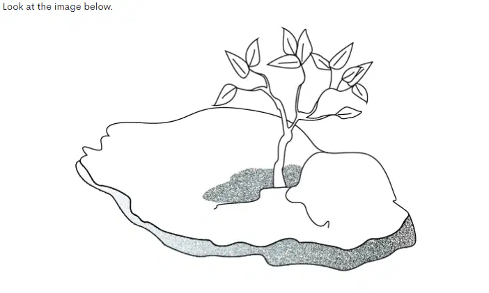
Which of the following has most likely happened?
¿Cuál de los siguientes es más probable que haya sucedido?
کدام یک از موارد زیر به احتمال زیاد اتفاق افتاده است؟
The plant has dissolved the rock.
La planta ha disuelto la roca.
گیاه سنگ را حل کرده است.
The plant has eroded the rock.
La planta ha erosionado la roca.
این گیاه سنگ را فرسایش داده است.
The plant has eaten away the rock.
La planta se ha comido la roca.
گیاه سنگ را خورده است.
The plant has weathered the rock.
La planta ha erosionado la roca.
این گیاه سنگ را هوازدگی کرده است.
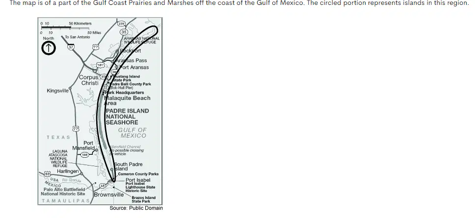
Which of the following best explains how these islands formed?
¿Cuál de los siguientes explica mejor cómo se formaron estas islas?
کدام یک از موارد زیر نحوه تشکیل این جزایر را بهتر توضیح می دهد؟
They formed by weathering as sediment collected in large piles along the tops of underwater reefs.
Se formaron por meteorización a medida que los sedimentos se acumulaban en grandes montones a lo largo de la parte superior de los arrecifes submarinos.
آنها در اثر هوازدگی به عنوان رسوب جمع آوری شده در انبوه های بزرگ در امتداد بالای صخره های زیر آب تشکیل شدند.
They formed by deposition as water carried and dropped sand from the shore as it slowed down.
Se formaron por deposición a medida que el agua transportaba y arrojaba arena desde la orilla a medida que disminuía la velocidad.
آنها با رسوب در هنگام حمل آب تشکیل می شوند و با کاهش سرعت ماسه از ساحل می ریزند.
They formed as underwater volcanoes erupted and deposited lava.
Se formaron cuando los volcanes submarinos entraron en erupción y depositaron lava.
آنها با فوران آتشفشان های زیر آب و رسوب گدازه تشکیل شدند.
They formed as hurricanes deposited sand from distant regions.
Se formaron cuando los huracanes depositaron arena desde regiones distantes.
آنها به عنوان طوفان های رسوب ماسه از مناطق دور تشکیل شدند.
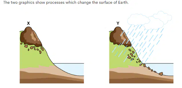
Which best describes the processes in the graphics?
¿Cuál describe mejor los procesos en los gráficos?
کدام به بهترین وجه فرآیندهای گرافیکی را توصیف می کند؟
Graphic X shows sediment being moved through erosion, and graphic Y shows rocks being broken down through deposition.
El gráfico X muestra los sedimentos que se mueven a través de la erosión, y el gráfico Y muestra las rocas que se descomponen a través de la deposición.
نمودار X رسوب را نشان می دهد که از طریق فرسایش جابجا می شود و گرافیک Y سنگ ها را نشان می دهد که از طریق رسوب تجزیه می شوند.
Graphic X shows rocks being broken down through weathering, and graphic Y shows sediment being moved through erosion.
El gráfico X muestra rocas que se descomponen a causa de la meteorización y el gráfico Y muestra sedimentos que se mueven a través de la erosión.
نمودار X سنگ ها را در اثر هوازدگی تجزیه می کند و گرافیک Y رسوبات را نشان می دهد که از طریق فرسایش جابجا می شوند.
Graphic X shows rocks being broken down through deposition, and graphic Y shows sediment being moved through weathering.
El gráfico X muestra rocas que se descomponen a través de la deposición, y el gráfico Y muestra sedimentos que se mueven a través de la meteorización.
نمودار X سنگ ها را در حال شکستن از طریق رسوب گذاری نشان می دهد و گرافیک Y رسوبات را نشان می دهد که از طریق هوازدگی جابجا می شوند.
Graphic X shows sediment being moved through weathering, and graphic Y shows rocks being broken down through sedimentation.
El gráfico X muestra los sedimentos que se mueven a través de la meteorización, y el gráfico Y muestra las rocas que se descomponen a través de la sedimentación.
نمودار X رسوب را نشان می دهد که از طریق هوازدگی جابجا می شود و گرافیک Y سنگ ها را نشان می دهد که از طریق رسوب تجزیه می شوند.
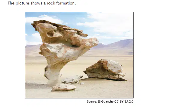
What most likely caused this rock formation?
wind erosion over many years
erosión eólica durante muchos años
فرسایش بادی در طی سالیان متمادی
erosion by waves over many years
erosión por las olas durante muchos años
فرسایش توسط امواج در طی سالیان متمادی
the rock was chipped away by animals
la roca fue picada por animales
سنگ توسط حیوانات کنده شد
high temperatures that melted the rock
altas temperaturas que derritieron la roca
دمای بالا که سنگ را ذوب کرد
Select all of the human activities that contribute to erosion.
Seleccione todas las actividades humanas que contribuyen a la erosión.
تمام فعالیت های انسانی که به فرسایش کمک می کنند را انتخاب کنید.
building parking lots
construcción de estacionamientos
ساخت پارکینگ ها
building roads
construyendo caminos
ساخت جاده ها
clearing land
limpiando la tierra
زمین پاکسازی
planting grass
plantando pasto
کاشت چمن
surface mining
Minería de superficie
استخراج سطحی
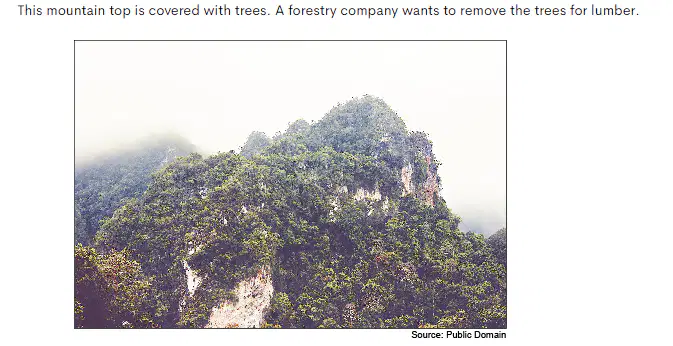
Which will most likely happen to the rocks on the mountain if the trees are removed?
¿Qué sucederá con mayor probabilidad con las rocas de la montaña si se quitan los árboles?
اگر درختان برداشته شوند، به احتمال زیاد چه اتفاقی برای سنگ های روی کوه می افتد؟
Wind and rain will begin to erode the rocks and the mountain will flatten over time.
El viento y la lluvia comenzarán a erosionar las rocas y la montaña se aplanará con el tiempo.
باد و باران شروع به فرسایش سنگ ها کرده و کوه به مرور زمان صاف می شود.
New trees will grow back very quickly and the mountain rocks will not be changed.
Los nuevos árboles volverán a crecer muy rápidamente y las rocas de la montaña no cambiarán.
درختان جدید خیلی سریع دوباره رشد خواهند کرد و سنگ های کوه تغییر نخواهند کرد.
The mountain will quickly become much smaller without the protection of the trees.
La montaña se volverá mucho más pequeña rápidamente sin la protección de los árboles.
کوه به سرعت بدون محافظت از درختان بسیار کوچکتر می شود.
The mountain will grow as additional sedimentary rocks are formed.
La montaña crecerá a medida que se formen rocas sedimentarias adicionales.
با تشکیل سنگ های رسوبی اضافی، کوه رشد خواهد کرد.
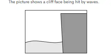
Which of the following pictures shows how the cliff will look after being hit by waves for many years?
¿Cuál de las siguientes imágenes muestra cómo se verá el acantilado después de haber sido golpeado por las olas durante muchos años?
کدام یک از تصاویر زیر نشان می دهد که صخره پس از برخورد امواج برای چندین سال چگونه خواهد بود؟


Why is the mantle important to the movement of Earth's plates?
¿Por qué es importante el manto para el movimiento de las placas de la Tierra?
چرا گوشته برای حرکت صفحات زمین مهم است؟
Conduction from the core creates strong magnetic fields in the mantle, which help to move Earth's plates.
La conducción desde el núcleo crea fuertes campos magnéticos en el manto, que ayudan a mover las placas de la Tierra.
هدایت از هسته میدانهای مغناطیسی قوی در گوشته ایجاد میکند که به حرکت صفحات زمین کمک میکند.
Pressure from the core creates convection currents in the mantle, which help to move Earth's plates.
La presión del núcleo crea corrientes de convección en el manto, que ayudan a mover las placas de la Tierra.
فشار از هسته جریانهای همرفتی را در گوشته ایجاد میکند که به حرکت صفحات زمین کمک میکند.
Heavy metals in the mantle create strong magnetic fields, which help to move Earth's plates.
Los metales pesados del manto crean fuertes campos magnéticos que ayudan a mover las placas de la Tierra.
فلزات سنگین در گوشته میدانهای مغناطیسی قوی ایجاد میکنند که به حرکت صفحات زمین کمک میکند.
Temperature differences in the mantle create convection currents, which help to move Earth's plates.
Las diferencias de temperatura en el manto crean corrientes de convección, que ayudan a mover las placas de la Tierra.
تفاوت دما در گوشته باعث ایجاد جریان های همرفتی می شود که به حرکت صفحات زمین کمک می کند.
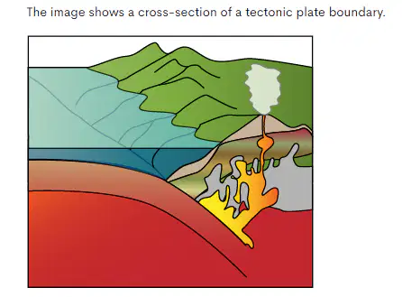
How does tectonic plate movement cause a volcano to form at this type of boundary?
¿Cómo provoca el movimiento de las placas tectónicas que se forme un volcán en este tipo de límite?
چگونه حرکت صفحه تکتونیکی باعث ایجاد یک آتشفشان در این نوع مرز می شود؟
When a tectonic plate collides with another tectonic plate of the same density, the rocky crust is pushed upward.
Cuando una placa tectónica choca con otra placa tectónica de la misma densidad, la corteza rocosa es empujada hacia arriba.
وقتی یک صفحه تکتونیکی با صفحه تکتونیکی دیگری با همان چگالی برخورد میکند، پوسته سنگی به سمت بالا رانده میشود.
When a tectonic plate slides against another tectonic plate, released energy travels through the rocky crust in waves.
Cuando una placa tectónica se desliza contra otra placa tectónica, la energía liberada viaja a través de la corteza rocosa en forma de ondas.
هنگامی که یک صفحه تکتونیکی روی صفحه تکتونیکی دیگری می لغزد، انرژی آزاد شده به صورت امواج از میان پوسته سنگی عبور می کند.
When a tectonic plate moves away from another tectonic plate, hot magma rises through the cool crust to form new crust.
Cuando una placa tectónica se aleja de otra placa tectónica, el magma caliente se eleva a través de la corteza fría para formar una nueva corteza.
هنگامی که یک صفحه تکتونیکی از صفحه تکتونیکی دیگری دور میشود، ماگمای داغ از میان پوسته سرد بالا میرود و پوسته جدید تشکیل میدهد.
When a tectonic plate moves under another tectonic plate, the rocky crust melts, which causes hot magma to rise to the surface.
Cuando una placa tectónica se mueve debajo de otra placa tectónica, la corteza rocosa se derrite, lo que hace que el magma caliente suba a la superficie.
هنگامی که یک صفحه تکتونیکی زیر صفحه تکتونیکی دیگری حرکت می کند، پوسته سنگی ذوب می شود که باعث می شود ماگمای داغ به سطح بالا بیاید.
What causes earthquakes to occur?
¿Qué provoca que se produzcan los terremotos?
علت وقوع زلزله چیست؟
erosion moving rocks and soil
erosión moviendo rocas y suelo
فرسایش سنگ های متحرک و خاک
the movement of tectonic plates that release energy
el movimiento de las placas tectónicas que liberan energía
حرکت صفحات تکتونیکی که انرژی آزاد می کنند
violent wind and rains shaking the ground
viento violento y lluvias sacudiendo el suelo
باد شدید و باران زمین را می لرزاند
underground currents of water flowing quickly
corrientes subterráneas de agua que fluyen rápidamente
جریان های زیرزمینی آب به سرعت جریان می یابد

What kind of activity is most likely at point X?
¿Qué tipo de actividad es más probable en el punto X?
چه نوع فعالیتی در نقطه X بیشتر محتمل است؟
massive storms, as the weak crust allows heat to spread from the mantle to the atmosphere and increase ocean temperatures
tormentas masivas, ya que la corteza débil permite que el calor se propague desde el manto a la atmósfera y aumente la temperatura del océano
طوفان های عظیم، زیرا پوسته ضعیف اجازه می دهد تا گرما از گوشته به جو پخش شود و دمای اقیانوس ها افزایش یابد.
strong drought, as the movement of material under the crust heats the waterways on the surface, causing them to evaporate
fuerte sequía, ya que el movimiento del material debajo de la corteza calienta los cursos de agua en la superficie, haciendo que se evaporen
خشکسالی شدید، زیرا حرکت مواد در زیر پوسته آبراهه ها را گرم می کند و باعث تبخیر آنها می شود.
earthquakes and volcanoes, as convection in the magma beneath the crust pulls the plates against each other
terremotos y volcanes, ya que la convección en el magma debajo de la corteza empuja las placas entre sí
زمین لرزه ها و آتشفشان ها، به عنوان همرفت در ماگما در زیر پوسته، صفحات را به سمت یکدیگر می کشد.
the formation of large valleys, as the rotation of Earth about its axis causes a downward pull on the plates
la formación de grandes valles, ya que la rotación de la Tierra alrededor de su eje provoca un tirón hacia abajo en las placas
تشکیل دره های بزرگ، زیرا چرخش زمین حول محور خود باعث کشش به سمت پایین صفحات می شود.
Where do scientists find evidence that the Earth's crust has been lifted above its original level?
heavy rocks in deep oceans
rocas pesadas en océanos profundos
سنگ های سنگین در اعماق اقیانوس ها
heavy rocks on mountain tops
rocas pesadas en las cimas de las montañas
سنگ های سنگین روی قله های کوه
fossils of sea animals found on mountaintops
fósiles de animales marinos encontrados en las cimas de las montañas
فسیل های حیوانات دریایی که در قله کوه ها یافت می شوند
fossils of sea animals deep in oceans
fósiles de animales marinos en lo profundo de los océanos
فسیل های جانوران دریایی در اعماق اقیانوس ها
What is the most likely reason that the bones of a Mesosaurus are found on the eastern coast of South America and on the western coast of Africa?
¿Cuál es la razón más probable por la que los huesos de un Mesosaurus se encuentran en la costa este de América del Sur y en la costa oeste de África?
محتمل ترین دلیلی که استخوان های مزوسوروس در سواحل شرقی آمریکای جنوبی و در سواحل غربی آفریقا یافت می شود چیست؟
flooding
inundación
جاری شدن سیل
geographic isolation
aislamiento geográfico
انزوای جغرافیایی
plate tectonics
placas tectónicas
تکتونیک صفحه ای
analogous structures
estructuras análogas
ساختارهای مشابه
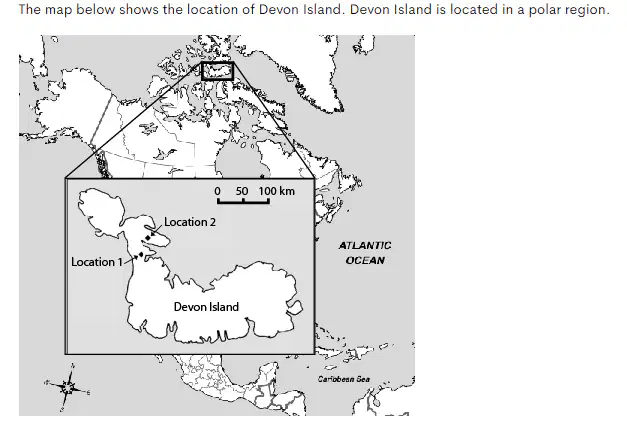
Scientists have discovered fossils of corals on Devon Island at Locations 1 and 2 shown on the map. Corals are ocean organisms that can only survive in warm waters. Which claim is BEST supported by the coral fossil evidence collected by scientists on Devon Island?
Devon Island was once part of the surrounding landmass of Canada.
La isla de Devon fue una vez parte de la masa terrestre circundante de Canadá.
جزیره دوون زمانی بخشی از خشکی اطراف کانادا بود.
The ocean waters surrounding Devon Island were once warmer than they are today.
Las aguas del océano que rodean la isla de Devon alguna vez fueron más cálidas de lo que son hoy.
آبهای اقیانوس اطراف جزیره دوون زمانی گرمتر از امروز بودند.
Devon Island was once part of the surrounding landmass of Greenland.
La isla de Devon fue una vez parte de la masa terrestre circundante de Groenlandia.
جزیره دوون زمانی بخشی از خشکی اطراف گرینلند بود.
The ocean waters surrounding Devon Island were once cooler than they are today.
Las aguas del océano que rodean la isla de Devon alguna vez fueron más frías de lo que son hoy.
.
آبهای اقیانوس اطراف جزیره دوون زمانی خنکتر از امروز بودند.
A very dark colored soil sample is taken from the Okefenokee Swamp. What is most likely the majority of the composition of the soil?
Se toma una muestra de suelo de color muy oscuro del pantano de Okefenokee. ¿Cuál es probablemente la mayor parte de la composición del suelo?
نمونه خاک بسیار تیره رنگ از مرداب Okefenokee گرفته شده است. به احتمال زیاد اکثریت ترکیب خاک چیست؟
sand and stones
rocks and minerals
dust and weathered rocks
polvo y rocas erosionadas
گرد و غبار و سنگ های هوازده
decomposed organic matter
materia organica descompuesta
مواد آلی تجزیه شده

