
 Worksheets
Part 107 Review
Total questions: 12
Worksheet time: 19mins

(Refer to Figure 21.) You have been hired by a farmer to use your small unmanned aircraft to inspect his crops. The area that you are to survey is in the Devil's Lake West MOA, east of area 2. How would you find out if the MOA is active?
Contact Flight Service (controlling agency)
Locate the information in the Small UAS database
Refer to the Military Operations Directory
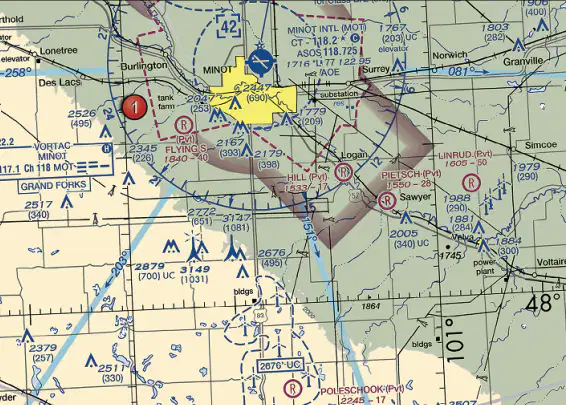
(Refer to FAA-CT-8080-2H, Figure 21) There's a cluster of towers 13 statute miles south of Minot Airport. What's the height of the tallest tower?
2,676 ft. MSL
3,147 ft. MSL
1,031 ft. AGL
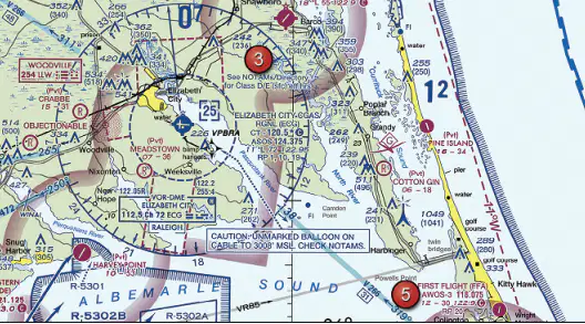
(Refer to Figure 20, area 5.) Who would a Remote Pilot in Command contact to "CHECK NOTAMS" as it is noted in the CAUTION box regarding the unmarked balloon?
Flight Service (controlling agency)
NTSB office
FAA district office
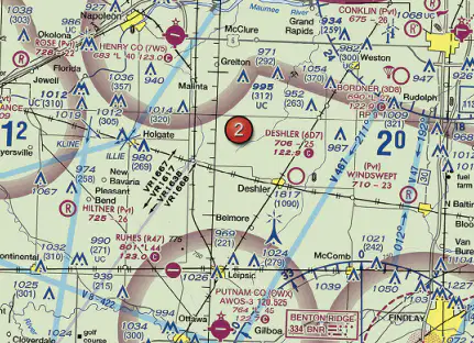
(Refer to FAA-CT-8080-2H, Figure 59, Area 2) The four lines that are labeled beginning with VR indicate
Military training routes.
Military operating areas.
Designated aircraft approach paths.
__________ areas are depicted on aeronautical charts with an “A” followed by a number (e.g., A-211) to inform nonparticipating pilots of areas that may contain a high volume of pilot training or an unusual type of aerial activity. Pilots should exercise caution in these areas.
Alert
Warning
MOA
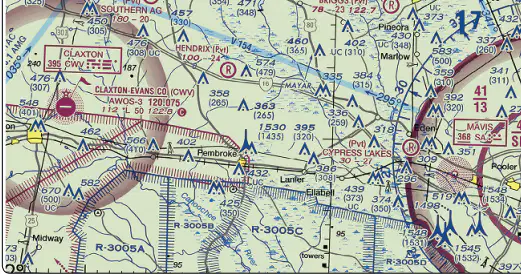
(Refer to Figure 23.) What does a restricted area like R-3005C mean?
Unusual, often invisible, hazards to aircraft like artillery firing, aerial gunnery, or guided missiles.
High-speed military training that requires unexpected maneuvers
Unusual type of aerial activity like a high volume of flight training
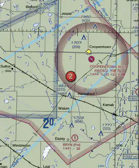
(Refer to Figure 26, area 2.) You've been asked to inspect the tower 4 to 5 statute miles northwest of Cooperstown airport (S32). How high must the cloud base be for you to be able to fly the maximum allowable height over the tower?
650 ft. AGL
1,150 ft. AGL
700 ft. AGL
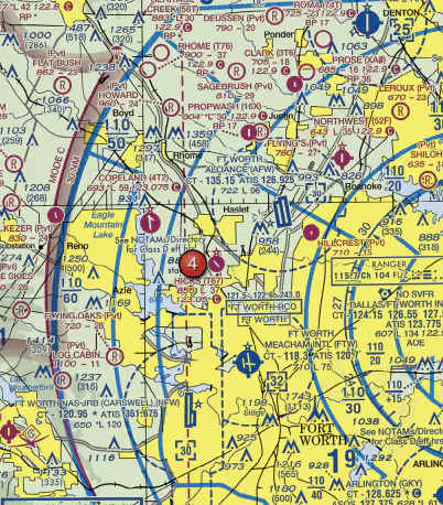
(Refer to Figure 25, area 4.) The airspace directly overlying Fort Worth Meacham International airport (FTW) is
Class D airspace to 3,200 feet MSL.
Class B airspace to 10,000 feet MSL.
Class C airspace to 5,000 feet MSL.

(Refer to Figure 21, area 2.) What's the minimum altitude / lowest elevation of the area depicted by the blue line labeled V15?
1,200 ft. AGL
700 ft. AGL
2,600 ft. AGL
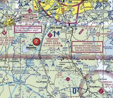
(Refer to FAA-CT-8080-2H, Figure 20, area 2.) The elevation of the Chesapeake Regional Airport is
19 feet.
36 feet.
360 feet.

(Refer to Figure 69.) What is the ATIS frequency at Corpus Christi Intl airport (CRP), and what is ATIS used for?
119.4, and ATIS is a nongovernment air/ground radio communication station which may provide airport information at public use airports where there’s no tower or FSS
126.8, and ATIS is a continuous broadcast of recorded aeronautical information in busier airports
122.95, and ATIS is a continuous broadcast of recorded aeronautical information in busier airports
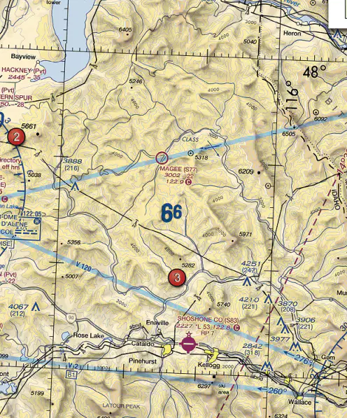
(Refer to FAA-CT-8080-2H, Figure 22, area 3.) Determine the approximate latitude and longitude of Shoshone County Airport.
47°33’N - 116°11’W
47°02’N - 116°11’W
47°32’N - 116°41’W

