
NEW
Font size
 Worksheets
West Africa Map Quiz
Total questions: 14
Worksheet time: 28mins
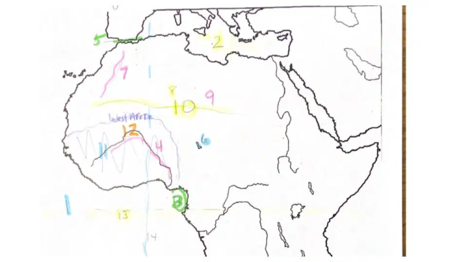
What feature is shown by #1?
Strait of Gibraltar
Lake Chad
Atlas Mountains
Atlantic Ocean
What feature is shown by #5?
The Sahara
Strait of Gibraltar
Djenne
Lake Chad
What feature is shown by #4?
Gulf of Guinea
Lake Chad
Niger River
Atlantic Ocean
What feature is shown by #10?
The Sahara
Ahaggar Mountains
Mediterranean Sea
Tibesti Mountains
What feature is shown by #8?
Timbuktu
Atlantic Ocean
Niger River
Ahaggar Mountains
What feature is shown by #7?
Tibesti Mountains
Atlas Mountains
Timbuktu
Dejenne
What city is shown by #11?
Mediterranean Sea
Dejenne
Lake Chad
Atlantic Ocean
What feature is shown by #3?
Dejenne
Tibesti Mountains
Gulf of Guinea
Atlas Mountains
What feature is shown by #2?
Niger River
Dejenne
Mediterranean Sea
Atlantic Ocean
What city is shown by #12?
Timbuktu
Strait of Gibraltar
Lake Chad
Atlas Mountains
What feature is shown by #6?
Timbuktu
Strait of Gibraltar
Lake Chad
Atlas Mountains
What feature is shown by #9?
Timbuktu
Strait of Gibraltar
Atlas Mountains
Tibesti Mountains
What feature is shown by the yellow dotted line for #13?
Timbuktu
Equator
Atlas Mountains
Tibesti Mountains
What feature is shown by the blue dotted line for #14?
Timbuktu
Equator
Prime Meridian
Tibesti Mountains

