
 Worksheets
Know Your Planet 2
Total questions: 69
Worksheet time: 37mins
What type of map would you use if you wanted to find the countries bordering Egypt?
Political
Physical
Special Purpose
Nothing
A map that shows mountains, rivers, deserts, etc is called a:
political map
physical maps
thematic maps
climatic maps
_______ hows information about the climate of an area.
political map
physical maps
thematic maps
climatic maps
A ____________ depicts variations in climate over a geographical area.
political map
physical maps
thematic maps
climatic maps
_______ may show overall climate according to a classification system based on averages or a single factor, such as temperature or rainfall
political map
physical maps
thematic maps
climatic maps
Maps that show the landforms like mountains, plateaus, plains or deserts are called:
Political Maps
Special Maps
Physical Maps
Climatic maps

Major cities and capital cities noted on map is called a....
Physical Map
Political Map

A map that shows physical features of the land is called a...
Physical Map
Political Map

This type of map shows landforms and bodies of water. What is it called?
Physical Map
Political Map

This map shows borders and boundaries. What is it called?
Physical Map
Political Map

These maps may be useful for pilots or mountain hikers. What is it called?
Physical Map
Political Map

This map is a...
physical map
road map
political map
thematic map

This is a...
political map
physical map
elevation map
thematic map
Something you would find on a physical map is...
a highway
a lake
a different subject
a border between states or countries
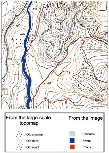
This map is an example of a . . .
Geologic Map
3D Map
Projection Map
Topographic Map
What type of map would be most helpful if you were looking for a steep trail to hike?
Geologic Map
Projection Map
3D Map
Topographic Map
Which one is a road map?


What type of map is this?
Climate
Political
Topological
Physical

What type of map is this?
Political
Road
Topological
Thematic
Which is the correct definition of a topological map?
Is also called a special-purpose, single-topic, or statistical map.
Shows countries, country borders, cities and capital cities, seas and oceans
is a type of diagram that has been simplified so that only vital information remains and unnecessary detail has been removed
What is the correct definition of a topographic map?
map is a type of diagram that has been simplified so that only vital information remains and unnecessary detail has been removed.
Refers to a detailed, graphical and accurate representation of features that appear on the Earth's surface. These geographical features can be mountains, water bodies and many more
a map showing roads especially for automobile travel.
Which is the correct definition for a climate map?
chart that shows the geographic distribution of the monthly or annual average values of climatic variables
a map, especially one designed for motorists, showing the roads of a country or area.
a map that shows countries, borders capital cities and other cities
Who is most likely to use a climate map for their job? (Check all that apply)
Scientists
Meteorologists (weather reporters)
Students
Climate activists
Who would use a topographic map? (check all that apply)
Geologists (a scientist who studies all things related to the Earth for example how it was formed and what it is made of)
Scientists
Hikers
Archaeologists (a scientist that studies human history by digging up human remains and objects)
Who might use a topographic map? (Check all that apply)
Commuters (a person who travels some distance to work on a regular basis.
Tourists
Students
Cats

Shows the directions on a map.
compass rose
scale
key
Some maps focus on specific information , they are
political maps
physical maps
Thematic maps
i


Northeast, Southeast, Northwest, and Southwest are all known as ____________________ directions.
main
cardinal
four
intermediate or sub directions
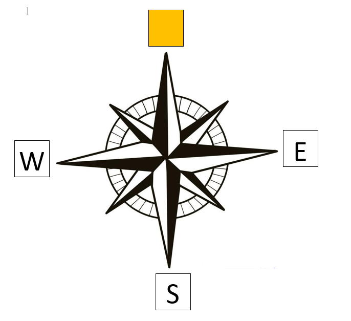
Which direction is missing?
North
East
Northwest

Which direction is missing?
North
East
Southeast
South

Which direction is missing?
West
Northwest
North

Which direction is missing?
North
Northeast
Southwest

Which direction is missing?
South
Northwest
Southeast
Which of the following is an Intermediate Direction?
North
East
Northeast
South
When you face the sun, which direction is to your right and to left
South,North
North,East
East , West
There are _______ cardinal directions.
3
5
4
6
When we use a compass the needle always points ___________.
North
South
East
West
A scale is necessary
for a map
for a sketch
for symbols
The ratio between the distance on the ground and the distance on the map is known as __________of the map.
Scale
Symbol
Model

Maps are always drawn to Scale
True
False
It is not easy to draw an absolutely correct map of the world because of the spherical shape of the Earth.
True
False
A map can be drawn even for a small area on the earth.
True
False
It is not possible to show the actual size of the Earth on a map because it is too large.
True
False
The ratio between the distance on the ground and the distance on the map is known as __________of the map.
Scale
Symbol
Model
Define map scale?
The ratio between the distance on the ground and the distance on the map.
A scale on the map.
shows directions
The ratio between the distance on a map and the actual distance on the ground is called
Direction
Sphere
Scale
Symbol
Maps are always drawn to scale.
True
False
There is not enough space on a map to show mountains, rivers, lakes,
bridges, dams, temples, churches and railway tracks.
True
False


What does this symbol mean?
Picnic Area
Cafe
Car Park
Zoo

What does this mean on a map?
Telephone
Car Park
Picnic
Play area

What does this mean?
Buckingham Palace
Weather Station
Igloo
Information
It is not possible to show all the features of an area in their actual shape and size. So we use symbols to represent the natural or man-made features on the Earth such as buildings, trails, roads, bridges and rivers.
True
False

A symbol is a drawing, line, or dot that stands for something else.
True
False

The land boundary of a
the country is shown by thick dashes and
dots in black
True
False
The symbol used to show a city on a map is
triangle
small circle
rectangle
dash.
We use different colours to show various things on a map.
True
False
on a physical map, water bodies are shown in shades of ______.
blue
light blue
green
brown
on a physical map, ________ is used for shallow waters
blue
light blue
green
brown
on a physical map, a ________ for deep waters.
blue
light blue
darker shade of blue
teal blue
on a physical map, . plains or lowlands are shown in shades of _____.
blue
light blue
green
brown
on a physical map, highlands are shown in shades of ______.
blue
light blue
green
brown
A key is given on a map to help us understand the colour scheme and the symbols used.
True
False

