
 Worksheets
Y9 EOY Quiz excluding Africa
Total questions: 117
Worksheet time: 1hrs 5mins
Human Development Report is published by
UNDP
World Bank
IMF
WHO
Which of the following is a necessary condition for sustainable development?
Increase in the quality of life
Reduction in the level of pollution
conservation of stock of natural capital
All of these
Which one of these is an example of a developed country?
China
India
Japan
North America
Countries with higher income are _____________ than others with less income.
Less developed
More developed
Less stronger
More organized
Which one of these is not a developed country?


Development of a country can generally be determined by its:
per capita income
average literacy level
health status of its people
none of these
Total income of the country divided by its
total population is known as: ‘
Capital Income
National Income
Per capita income
GDP
Name countries that are getting Americas e-waste?
India
China
Pakistan
Nigeria
Ghana
Where is the most e-waste generated from?
USA
Europe
India
China
What percent of recycled electronics end up in developing countries?
10%
30%
50%
80%
Name 3 most toxic compounds found in e-waste?
Lead
Zinc
Cadimum
Mercury
What percentage of cell phones are recycled?
10%
20%
40%
50%
What can manufactures do to help out with the problem?
Clean up the products by eliminating toxins and have a return policy
Not to manufacture products creating e-waste
Create awareness about e-waste
Attaching information about recycle centers in nearby area
Chocolate is one of the worlds favourite foods. What bean is harvested to make it?
runner bean
baked bean
broad bean
cocoa bean
What clothing item is grown by Fairtrade farmers?
leather
wool
cotton
What two popular drinks are farmed under Fairtrade?
coke and lemonade
coffee and orange squash
coffee and tea
tea and coke
Who can buy Fairtrade products?
rich people
no one in Australia
anyone
What does export mean?
to sell products or raw materials to another country
to buy products or raw materials from another country
to visit another country for trading
a trade that happens with more than two countries
To _________ products or raw materials means to buy them from another country for use in your own country.
export
trade
import
buy
Something that is unethical is ...
morally right or morally acceptable
immoral (not right or acceptable)
illegal
true
What is a co-operative?
a group of countries who buy and sell products
a group of farmers who share equipment/machinery
two countries who trade
someone who grows bananas
What is Fairtrade all about?
better prices and better working conditions
more trade for less money
less money for workers
less crops
Which of these would help a community?
renovating a school
medicines for the local hospital
holidays
creating clean water supplies
A __________ is something that is sold for money.
product
commodity
trade
consumer
What would you call someone who buys and sells commodities for profit?
consumer
producer
merchant
Marco Polo
What are consumers?
shoppers
traders
countries
cities
A river's ________________ is the starting point of the river.
source
triutaries
mouth
drainage basin
________________ are streams that flow together to make a river.
source
tributaries
mouth
drainage basin
The place where the river pours (THROWS UP) into the ocean or large lake is called the ___________.
source
tributaries
mouth
drainage basin
The area of land DRAINED by a river system is called the _____________
drainage basin
mouth
tributaries
source
The Yellow and Yangtze River are located in _________.
Pakistan
China
Antarctica
Mrs. Call Land
The Indus River is located in ______________.
Russia
Pakistan
Your Backyard
What is the longest river in the world?
The Nile River
The mouth
The Indus River

What landform can you see in the picture?
U shaped valley
V Shaped Valley
Floodplain
Waterfall

Which landform can be seen in the photo?
Waterfall
Estuary
Inter-locking Spur
Meander

What landform can you see in this picture?
Waterfall
V Shaped Valley
Meander
Ox-bow lake
What is the deep water called beneath a waterfall?
Plunge bath
Mermaids retreat
Plunge pool
Pool

What landform can you see in the picture?
Meanders
Rapids
Estuary
V shaped valleys
The river undercuts the hard rock, creating an overhang.
True
False
"Water cuts into the rock and wears it away," This is called...
sediment
deposition
erosion
Which erosion processes are dominant in the plunge pool?
Hydraulic action
Attrition
Solution
Abrasion
When the overhang collapses the waterfall moves upstream. What is this called?
backup
retreat
surrender
A steep sided valley is formed as a waterfall retreats upstream. This is called a ......
v-shaped valley
gorge
On a meander, the fastest flowing part of the river is...
the outside bend
the inside bend
the left hand side
the middle
Why do rivers become wider downstream? (Select all that apply)
There is more lateral erosion
Tributaries feed the rivers more water
There is more space for them to spread out
They carry more sediment
Which type of erosion is more common in the middle course of a river?
Vertical
Lateral
On the outside bend of a meander, what types of erosion cause the river cliff to collapse into the river? (Select all that apply)
Abrasion
Attrition
Solution
Hydraulic action
What feature is being described here? The inside bank of a meander on a river where sedimentary material is deposited as a result of the slower flow rate
Overhang
River cliff
Slip-off slope
Meander

When a meander becomes very pronounced, this feature is formed. What is it called?
U bend
Horse shoe lake
Oxbow lake
An undercut

What would the river channel look like from B to B'


What would the river channel look like from C to C'


What factor(s) determine a river's ability to erode sediment?
Velocity
Gradient
Discharge
Stream Channel Shape


What is a flood?
When too much water falls from the sky
When lots of water reaches the land
When a river bursts its banks
When a river meets the sea

How does a built up area increase flooding?
The water enters the river more slowly
Less water is absorbed because concrete and build up areas are not permeable surfaces (water cannot go through)
There is more opportunity for the water to be absorbed because concrete and built up areas are permeable surfaces (water can go through)
There is more green space

Why does having lots of plants make flooding slower?
The plants cannot absorb water very fast
The plants' roots are connected to the river
The plants absorb water (interception) so the water takes longer to reach the river
Plants increase run-off
What do we call a chart of a river from source to mouth?
long profile
length profile
extent profile
elongated profile
The river discharge is greater in the...
Upper course
Lower course
The occupied channel width is greater in the...
upper course
lower course
The load particle size is greater in the...
Upper course
Lower course
The channel depth is greater in the...
Upper course
Lower course
Average velocity is greater in the...
Upper course
Lower course
Load quantity is greater in the...
Upper course
Lower course

A diagram that pretends to slice a river like a cake, so you can see sideways bank-to-bank is called a...
Cross profile
Width profile
Side profile
Intersect profile
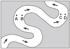
Which two locations have the fastest water flow?
A and B
B and C
C and D
D and A

The process in which sediment settles out (drops to the bottom) of the water or wind that is carrying it
Weathering
Erosion
Sedimentation
Deposition
This is when rocks being carried by the river break down by hitting against each other
Attrition
Abrasion
Hydraulic Action
Soliution
This is the wearing away of the bed and banks of the river by the materials being carried by the river.
Attrition
Abrasion
Hydraulic Action
Solution
This is the wearing away of the river bed and banks by the force of the water hitting against them
Attrition
Hydraulic Action
Solution
Abrasion
This involves the wearing away of the river bed and banks due the minerals in the rocks dissolving in the water
Attrition
Solution
Abrasion
Hydraulic Action
This is when materials move along the river bed by bouncing
Saltation
Traction
Suspension
Solution
This is the process of transporting dissolved materials in a river
Saltation
Solution
Traction
Suspension
This is when materials are transported by floating along in the river
Saltation
Solution
Traction
Suspension
Some materials are too heavy to float or bounce and so they are rolled along the river bed
Traction
Solution
Saltation
Suspension

Which best describes this diagram?
divergent boundary
subduction zone
transform boundary
volcanic islands forming

The diagram illustrates that
seafloor spreading occurs at a convergent boundary
the oldest oceanic crust is located far from where the plates are separating
the continents are slowly moving toward each other
the youngest oceanic crust is located far from where it is separating
The densest layer of Earth is
the lithosphere
the mantle
the core
the crust

This movement of tectonic plates will MOST likely cause
mountains to form
seafloor spreading
an earthquake
a rift valley

What causes the tectonic plates to move?
rotation of the Earth
convection currents
earthquakes
gravity from the core
The Earth's surface is divided into
several oceanic plates
oceanic and continental plates
continental and crustal plates
seven continental plates
Alfred Wegener proposed the idea of
the Big Bang theory.
the theory of Plate Tectonics.
biodiversity.
natural selection.

Which features are commonly formed at the plate boundaries where continental crust converges with oceanic crust?
long chains of mid-ocean volcanic islands perpendicular to the coast
large volcanic mountain ranges parallel to the coast at the center of the continents
a deep ocean trench and a continental volcanic mountain range near the coast
an underwater volcanic mountain range and rift valley on the ocean ridge near the
coast

complete the sentence :
the pocket underneath the volcano stores .............
air
lava
magma
water
what are the 3 types of volcano
active volcano
dormant volcano
extinct volcano
non living volcano
living volcano
tell a negative and positive effect of volcano
will help the plant to grow
destroy all homes
the smoke will help the environment
What is magma?
pieces of the Earth's crust
molten rock inside of a volcano
small rock
plates that meet


A ______ is a duct connecting the magma chamber and the outside of the volcano.
Vent
Crater
Lava flow
Volcanic cone

What is the definition of core?
the 2nd layer
the center of the Earth
molten rock
outer layer of the Earth
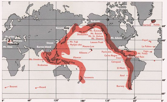
What was the magnitude (size) of the earthquake? Haiti.
6.2
7.0
7.4
6.8
When did the earthquake strike? Haiti.
12 January 2010.
16 June 2011
12 January 2012
16 June 2010
What percentage of the country has people access to clean water? Haiti.
55
32
46
78
Haiti. Would you consider to be a HIC or LIC?
HIC
LIC
How many people were placed in aid camps? Haiti.
810,000
790,000
807,000
540,000
In the days after the disaster there were more than 20 aftershocks? Haiti.
False
True
How many people were affected by the natural disaster in Haiti?
1.5 million people were affected by losing their homes.
1 million people were affected after losing their businesses.
2.5 million people were affected after losing their families.
1.5 million people were affected after losing their jobs.
What are most tsunamis caused by?
Hurricanes
Tornadoes
Earthquakes
Landslides
Which image shows a tsunami in action?


Tsunamis can be
as high as 100 feet.
as high as 2 feet.
as high as 1,000 feet.
as high as 10,000 feet.

