
 Worksheets
Geography Gr5B
Total questions: 50
Worksheet time: 1hrs 15mins


Which country is labeled 5?
(a)

lines that run north to south around the earth
(a)

a map maker
scientist
cartographer
geologist
geographer

What is the name of this line at 0 degrees latitude?
(a)

Which continent is highlighted?
(a)

Which is a famous line of Latitude?
Prime meridian
Equator
Any moisture reaching the surface of the earth such as rain, snow, hail or sleet is called (a)
The long term weather pattern for a place or a region is called (a)

Select all the physical landforms below.
Mount Everest
The Great Wall of China
Peninsula
Plateau
Check all of the natural disasters.
Earthquake
Tsunami
Strait
Plateau

A place with unifying characteristics such as climate, land, population, or history.
Place
Country
Region
Continent
What is the name of the large desert that covers most of northern Africa?
(a)

A giant wave usually caused by an earthquake beneath the ocean floor.
Earthquake
Monsoon
Tsunami
Tornado

What country is in blue?
Israel
UAE
Jordan
Iraq

What is G?
(a)

What country is in green?
Iran
Iraq
Saudi Arabia
Turkey

Name the Tectonic Plate
(a)
What is a Transform boundary?
When plates push apart
When plates collide
When plates slide past eachother
None of the above
There are more volcanoes and earthquakes in the Ring of Fire than anywhere else in the world.
True
False
What are the plates that form the Earth's crust called?
Teton plates
Technology plates
Temperature plates
Tectonic Plates
I happen two times a year, that is when my day and night both last the same length of time. What am I called
(a)
I happen twice a year due to earth's tilt, once in the summer and the second time in the winter.
(a)
I am a piece of land surrounded by water, what am I called
(a)
An extensive group island or a chain of island is called an (a)
I am a low area between mountains or hills. What am I called.
(a)

What Country is Showen Here?
(a)

What Country Is This?
(a)

What is Country 6
(a)
What is Country 11
(a)

What country is shown?
(a)


Which country is shown here?
(a)

Identify the shaded country
Turkmenistan
China
Mongolia
North Korea

Smaller than a gulf but bigger than a cove
(a)

This is a picture of what landform
(a)

Do NOT focus on the rock, what do you see
(a)

Focus on the dip between mountains, what is it called
(a)


Narrow body of water connecting/between two larger bodies of water
swamp
isthmus
strait
valley
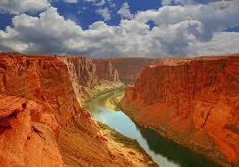
What land form is this?
(a)

Name this landform.
(a)

Large part of an ocean that extends to land
sea
ocean
gulf
river
The water cycle has 3 stages, name them
(a)

What country is in green?
Switzerland
Denmark
Ireland
Greece
Africa is the (a) largest continent in the world, spanning 5,000 miles from end to end.

Which continent is highlighted?
(a)

