
 Worksheets
Year 8 Geography Skills 2023
Total questions: 60
Worksheet time: 33mins
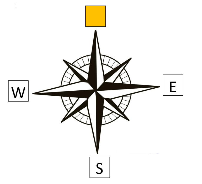
Which direction is missing?
North
East
Northwest
South
Northeast

Which direction is missing?
North
East
Southeast
South
Southwest

Which direction is missing?
West
Northwest
North
Northeast
Southwest

Which direction is missing?
North
Northwest
Southeast
Northeast
Southwest

Which direction is missing?
South
Northwest
Southeast
Northeast
Southwest




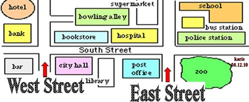
What is the name of the tool that shows cardinal and intermediate directions?
line of longitude
compass rose
map
key
With direction, "From" is always...
Last step
Second step
Your starting point

What is the elevation (height) of Point A?
900
90
1000
1500
On a map, the height above sea level is known as the:
Contour line
Contour interval
Scale
Elevation

What is the contour interval on this topographic map?
50
1000
100
20
Which of the following is not a physical feature?
Rock
Dam
Lake
Mountain

What is the contour interval?
100
20
10
40
Contour lines that are far apart indicate that:
The land is very steep
Elevation is very high
There is a steep slope
There is a gradual slope

How many hills are in this picture?
2
3
5
6

What is the height (or elevation) of point Y?
500
460
420
400

What direction am I travelling in if I move from point X to point Y?
North
East
South
West

What is the four-figure area reference for A?
1533
1534
1334
1332
Northings refer to ...
The lines which have numbers increasing as they head towards North(Y-axis)
The lines which have numbers increasing as they head towards the East (X-axis)
The lines which have numbers increasing as they head towards the west (X-axis)
The lines which have numbers as they head towards the South (Y-axis)

In what Area Reference (AR) will you find Tai's Hut? Hint look at the symbol not the words
AR 7319
AR 1973
AR 7318
AR 7418
AR 7419

What is the elevation (height) of Point C and its Area Reference (AR)?
Elevation: 150-200m; AR 8746
Elevation: 150-200m; AR 8846
Elevation: 150-200m; AR 4688
Elevation: 100-150m; AR 8846

What is the distance from Point E to Point H?
3.8 km
4.2 km
4.8 km
5.8 km
8.4 km

What direction is Point V from Point A?
NW
NNW
WNW
SE
ESE

Which Easting is closest to the Skate Park on this map?
17
18
30
31

Identify TWO physical features from AR 1321.
Ferry and Road
Houses and Road
Beach and Forest
Beach and Cliffs

Interpret the scale of this Topographic Map.
1cm = 1m
1cm = 100m
1cm = 1km
1cm = 10km
1cm = 1000km

What TWO elements of BOLTS are found in AR 6884?
Origin and Size
Orientation and Scale
Orientation and Legend
Origin and Scale

What is the dominant vegetation type on the eastern side of the island?
moorland
forest
grasslands
beach
loch
The ways scale can be shown on a map are:
ratio, line, written
line, number, words
ratio and written
line and ratio
Scale is important because
it tells us what 1 cm represents
we can use it to work out distance
it shows us what symbols on the map mean
it tells us what the map is about
1:100 000 means that
1cm on the map represents 1m
1cm on the map represents 10 km
1cm on the map represents 1km
1cm on the map represents 100m
The scale of a map is 1:250 000. If the distance between point A and Point B is 10cm on the map, how far is that in reality.
2.5km
25km
250km
250m
The scale of a map is 1:50 000. If the distance between point A and Point B is 1cm on the map, how far is that in reality.
5 m
500 m
50 m
5 km
The ways scale can be shown on a map are:
ratio, line, written
line, number, words
ratio and written
line and ratio
A place with landform features is called..
Low land area
A steep area
Landscape
River valley
What are contour lines?
Lines showing high land areas
Different between contour lines
Lines that represents a same height about sea level
Lines that shows a steepness of a place.
What is contour interval?
Index lines on a map
The difference between two contour lines
Indicate an elevator of a place from sea level
Represents a gradient
A landscape is....
Mountain
Place that has many rivers
A place full of landform features.
A steel slopes

The height above sea level is called
topographic
contour
elevation
depth
An important reason that Contour mapping exists is..
Provides Geographers and cartographers an opportunity to best represent and study the '3D' form of the land's surface.
For artistic results.
As a confusing flat pancake 2D version of the world.
Allows or give crocodiles an understanding of the typography.
A low lying area between two hills or ridges,often occupied by a river
Plateau
A valley
Plain
Desert

If contour lines are close together, then the slope is
gentle
steep
flat
going up and down

On a topographic map of a mountain, you walk a longer distance to get to the top when the contour lines are
spread out
close together
going down
going up

Which side of the hill would be hardest to climb?
South side
East side
North side
West side

What is the contour interval of this map?
10
20
30
40

Which side is steeper?
The left side of the hill
The right side of the hill

Match the topographic map to its profile.


Match the topographic map to its profile picture.


How can you tell a map shows a steep slope?
The lines are far apart from each other
The lines are close to each other
Where do we measure the height of the land from?
The nearest part of flat land
The centre of the earth
Sea level
The top of a hill




