
 Worksheets
Year 7 Geography Assessment Quiz
Total questions: 40
Worksheet time: 45mins

What is the water cycle?
The 3 forms of water
The movement of water on, above, or below the surface of the Earth
When water melts after being in a frozen state
When clouds form in the sky
As water moves through the water cycle, water changes form, but it never disappears.
true
false
Which is these is NOT a part of the water cycle?
Transpiration
Respiration
Percolation
Transmigration
Which is the correct definition for percolation?
When plants let water out
When water run-off flows underground
When water heats up and rises into the atmosphere
When water falls from the sky
An example of water use in trade
showers, baths and garden watering
irrigation
transportation of goods along rivers and across oceans
water cooling systems in nuclear power plants
Why do most Australians live along the coast? (you will select more than one answer)
mild temperatures
access to trade with New Zealand
plentiful rainfall
excellent farmland
The Great Dividing Range is a geological feature that...
runs along much of the East Coast of Australia
Affects the Great Artesian Basin
Affects the climate and environments on the East Coast
Influences population distribution

Which best explains why water runoff is important?
It returns water to other locations on Earth
It increases the chance of flooding
It makes evaporation occur faster
It increases condensation

What is it called when plants give off water vapor as a waste product?
condensation
evaporation
sublimation
transpiration
How much of the Earth's fresh water in drinkable?
1%
11%
2%
99%
Which industry uses the most water in Australia?
Advertising
Agriculture
Accounting
Aeronautical
What is the name of the large body of ground water underneath much of Australia's east?
The Great Big Waterhole
The Great Wet Lake
The Great Underground Watery Place
The Great Artesian Basin
A city that is closer to the equator will have what type of weather?
Cooler & windier
Warmer & windier
Warmer & wetter
Cooler & wetter

Which is higher, Crow Mountain or Eagle Mountain?
Crow
Eagle
Neither
In which direction does Deer River Flow?
North
South
South West
North East
True or False:
Wolf Pond is directly fed by two rivers
TRUE
FALSE
Of the points listed below, which is the lowest?
I
F
H
C
B
political
Thematic

What type of map would you use to find a local height of a mountain?
Thematic
Physical
Political
Street Map

What type of map would you use to find the climate zones of a country?
Thematic
Physical
Political
Street Map
Another name for a geographical LEGEND could be?
Lock
Latitude
Key
List

When Contour lines are further apart the land would be?
Flat
on a gradual slope or incline
Very high or Steep
Wet
What is the study of Geography?
Where a place is located in relation to another place.
The study of features on earth's surface, including landforms, water bodies, climate, plants, animals, and people.
It usually describes the area shown on a map.
The precise point where a place is located on earth.
What is a Compass Rose?
It usually describes the area shown on the map.
A diagram on a map that shows directons such as north, south, east, and west.
It lists each symbol and explains what is shown on the map.
The study of features of earth's surface
The Equator is...
The meridian labeled 0 degrees from which all other degrees of longitude are measured. It passes through Greenwich, England.
The line of latitude that circles Earth exactly midweay between the North and South poles.
The Meridian of Longitude located at 180 degrees. By international agreement, the date is one day earlier to the east of this line.
One half of a sphere. The Earth can be divided into eastern, western, southern, or northern sections.

What is directly east of the picnic area?
Swimming pool
Playground
Ice-cream stand
soccer field

What shows the distances in a map?
compass rose
key
scale
latitude and longitude

A map that shows the lines that separate one continent, country, or state from another.
physical map
border
political map
thematic map

The land where a group of people are united under a single government.
compass rose
continent
country
communism

What kind of map is this?
Physical map
Political map
Thematic
Topographical

What religion is shown by the colour blue?
Christianity
Buddhism
Judaism
Hinduism
There is no blue

Where is Mount Brown? Give a four digit area reference for it
AR2729
AR6828
AR2869
AR2868

What is the AR for the southernmost camping ground?
AR244682
AR251668
AR250678
AR345890
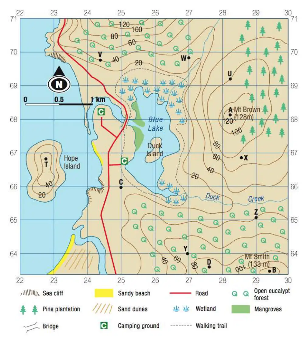
The mountain with the highest elevation (greatest height) on this map is Mount Brown.
True
False

This area around Mount Brown is all untouched native forest.
Yes. Pine Plantations are a natural part of the ecosystem
Yes. The area is filled with native eucalyptus trees.
No. Pine plantations are not native to the area.
No. The entire area is affected by desertification.
Grassland Climates in the Northern Territory have...
hot summers and cold winters
Mild winters and hhot summers
are hot and dry all year round
have hot and humid summers
According to the United Nations, what is the most important water priority for member nations?
Agriculture safe water
washing/laundry
drinking
wetland renewal
According to the United Nations, how many people live in water-stressed situations?
6 billion
2.4 million
2.5 billion
2.4 billion

