wayground logo

Free Printable Worksheets

NEW

Font size

S
M
L
XL
Worksheets

Unit 2: Map Skills Quiz

Total questions: 37

Worksheet time: 28mins

Name
Class
Date
1.
What is the map element that tells what symbols on the map mean?
a)
Key/Compass
b)
Key/Legend
c)
Legend/Scale
d)
Inset/Scale
2.

What city is located closest to 70'W and 40'N?

a)

Denver

b)

Niagra Fallas

c)

Boston

d)

Houston

3.

What is the name of the imaginary line that runs from east to west, and separates the Northern and Southern Hemispheres?

a)

Equator

b)

Prime Meridian

c)

Longitude

d)

Latitude

4.

What is the name of the imaginary line on the globe that runs north to south, and separates the Eastern and Western Hemispheres?

a)

Equator

b)

Prime Meridian

c)

Latitude

d)

Longitude

5.

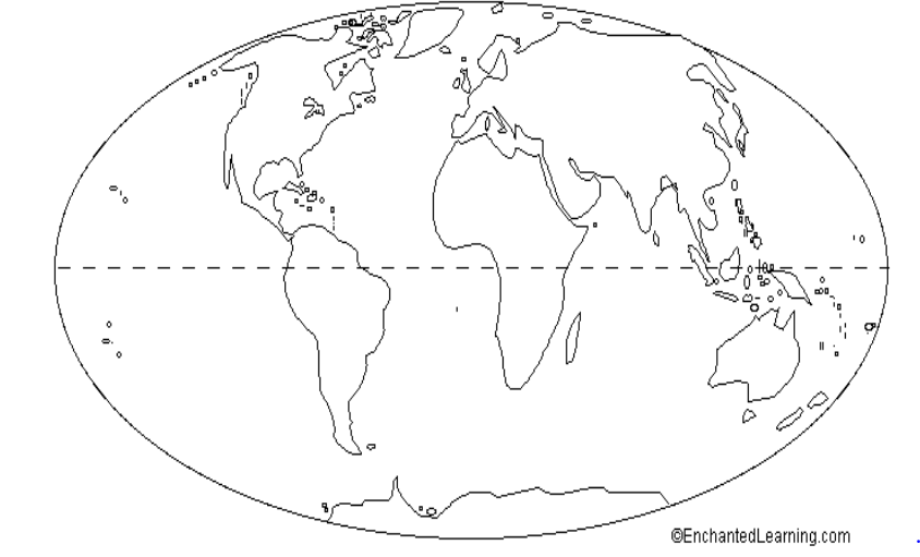
Identify this map

a)

Population map

b)

Elevation Map

c)

Physical Map

d)

Political Map

6.

This map is an example of a . . .

a)

Political Map

b)

Physical Map

7.

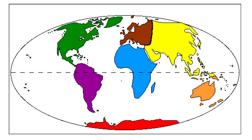
What is the name of the blue continent?

a)

Asia

b)

Africa

c)

Antarctica

d)

Australia

8.

What is the name of the brown continent?

a)

Antarctica

b)

Europe

c)

Africa

d)

South America

9.

What is the name of the yellow continent?

a)

Africa

b)

Europe

c)

Australia

d)

Asia

10.

What is the name of the ocean labeled with a letter B?

a)

Arctic Ocean

b)

Southern Ocean

c)

Indian Ocean

d)

Atlantic Ocean

11.

What is the name of the ocean labeled with a letter C?

a)

Pacific Ocean

b)

Indian Ocean

c)

Arctic Ocean

d)

Atlantic Ocean

12.
Measures distance from the equator. These lines run east and west and measure north and south.
a)
Cardinal Directions
b)
Latitude Lines
c)
Longitude Lines
d)
Intermediate Directions
13.
__________ directions are northeast, southeast, southwest, and northwest.
a)
Latitude
b)
Cardinal
c)
Intermediate
d)
Longitudinal
14.
The red question mark is located to the _________ of the compass rose.
a)
North
b)
Northeast
c)
Northwest
d)
East
15.

What tool would you use to measure the distance between two places on a map?

a)

key

b)

legend

c)

scale

d)

grid

16.

0 degrees longitude; an imaginary line that runs up and down through the United Kingdom

a)

Prime Meridian

b)

Equator

17.

0 degrees latitude; an imaginary line that runs around the middle of Earth, like a belt

a)

Prime Meridian

b)

Equator

18.

How many hemispheres does the earth have?

a)

1

b)

2

c)

3

d)

4

19.
The four main points of the compass North, South, East, and West.
a)
Compass Rose
b)
Cardinal Directions
c)
Intermediate Directions
d)
Map Scale
20.
Which continent is located at letter "A"?
a)
Antarctica
b)
Africa
c)
Australia
d)
Asia
21.
Which continent is located at letter "B"?
a)
North America
b)
South America
c)
Central America
d)
African America
22.
What Continent do you live on?
a)
South America
b)
Europe
c)
North America
d)
Australia
23.
Which of the following letter is at approximately 60 degrees S, 40 degrees W? 
a)
A
b)
D
c)
E
d)
H
24.
What city is located at 32 degrees south and 150 degrees east?
a)
Shanghai
b)
Sydney
c)
Durban
d)
Calcutta 
25.
Which city is located at 38 degrees north and 120 degrees west?
a)
San Fransisco 
b)
New York
c)
New Orleans
d)
London
26.
What are the coordinates for the city of New Orleans? 
a)
30 degrees north and 90 degrees west
b)
60 degrees north and 30 degrees east
c)
30 degrees north and 120 degrees east
d)
35 degrees north and 70 degrees west
27.
If you were at 30 degrees south and 60 degrees west, which continent would you be in?
a)
Europe
b)
Africa
c)
South America
d)
Australia 
28.
Which letter would you find at 15oS, 60oW?
a)
A
b)
C
c)
L
d)
H
29.

New York City is famous for the Statue of Liberty, the Knicks, Empire State Building, and its diverse culture.

a)

Location

b)

Place

c)

Human-Environmental Interaction

d)

Region

30.

Many goods in from North and South America are shipped through the Panama Canal.

a)

Location

b)

Place

c)

Movement

d)

Region

31.

China, Japan, and South Korea are found in East Asia.

a)

Location

b)

Place

c)

Movement

d)

Region

32.

The people of India deal with frequent floods by building dams and water reserves.

a)

Location

b)

Place

c)

Movement

d)

Human-Environmental Interaction

33.

Boston is north of New York City, east of Toronto, and south of Maine.

a)

Location

b)

Place

c)

Movement

d)

Human-Environmental Interaction

34.

France is home to beautiful beaches, historical sites, and the Eiffel Tower .

a)

Location

b)

Place

c)

Movement

d)

Region

35.
The statement:  "The Eiffel Tower is located at 48.8584° N, 2.2945° E," is an example of which of the 5 Themes of Geography?
a)
Movement
b)
Region
c)
Place
d)
Location
36.
Syrian refugees fleeing the Middle East into Europe and sanctuary countries around the world is an example of which of the 5 Themes of Geography?
a)
Place
b)
Location
c)
Movement
d)
Human-Environment Interaction
37.
Absolute location is:
a)
general
b)
not used on GPS
c)
is saying that Two Rivers is in East Hartford
d)
uses latitude and longitude to give a specific area