
Font size
 Worksheets
Unit 1 Review
Total questions: 21
Worksheet time: 13mins
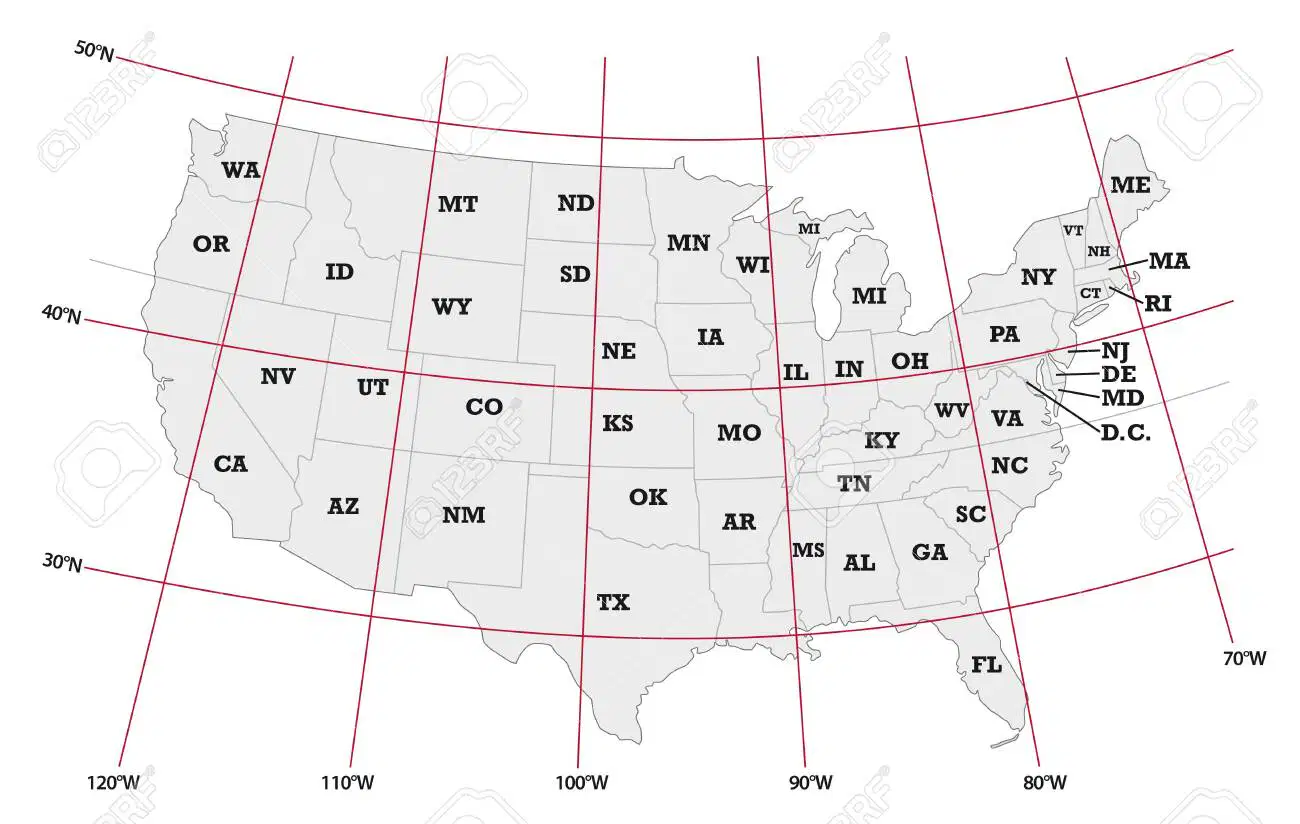
33°N latitude, 112°W longitude is near _____________
CA
MI
GA
KY
Distortion is a problem when mapping Earth because
Earth’s curved surface is transferred to a flat surface
current map-producing technology is limited
Earth’s populations are constantly changing
climate conditions are difficult to measure
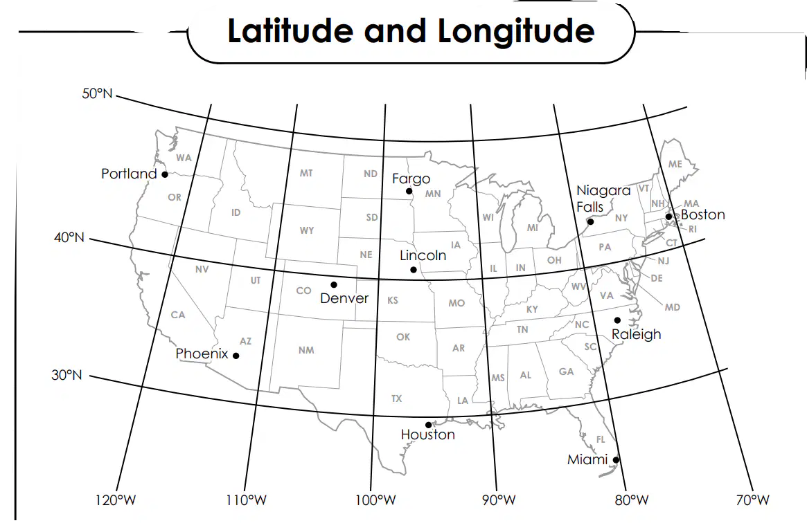
35°N latitude, 78°W longitude ________________________________________
Raleigh
Denver
Pheonix
Lincoln

A map that focuses on showing landforms and elevation is called a:
Climate
thematic
politcal
physical

The compass rose is an essential part of a map. Which cardinal direction does it typically show?
N,S,SE,NW
N, E, S, W
NE, SE, NW, SW
U,D,L,R

What is the purpose of a scale on a map?
To indicate cardinal directions
To show longitude and latitude lines
To represent distances on the map
To display the key (legend) of the map
Which direction is directly opposite to the east?
North
East
South
West

Why are bar graphs useful for identifying trends and patterns?
They can only display data for a single category at a time.
They make comparing data between categories or groups easy.
They are not suitable for visualizing data in presentations.
They require complex data analysis skills to interpret.

What information does a map's grid system provide?
absolute locations
human characters
physical characteristics
relative locations

43°N latitude, 79°W longitude _______________________________________5
Fargo
Niagra Falls
Lincoln
Portland

What is a primary source?
A news article reporting on an event
A textbook written by a historian
An original document or artifact created during that time
A website providing information about a historical event

What makes a secondary source different from a primary source?
Secondary sources analyze and interpret primary sources.
Secondary sources analyze and interpret primary sources.
Historians create secondary sources.
Secondary sources provide more accurate information.

Which type of source would historians consider the most reliable when
secondary sources created by ancient civilizations?
To gain firsthand information about past events and people
To summarize and interpret historical data
To provide different perspectives on a historical event
To support arguments and theories with evidence
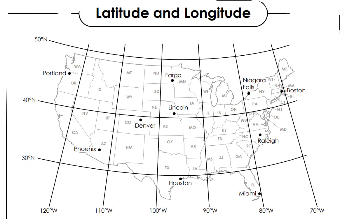
25°N latitude, 81°W longitude _______________________________________
Denver
Miami
Pheonix
Los Angeles
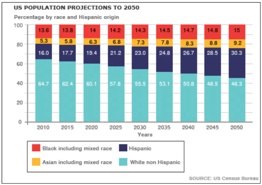
According to the graph, which ethnic group is decreasing?
Asians
Blacks
Hispanics
Whites

What type of map would you use to understand population density in different dividing lines of regions of a country?
political
thematic
physical
topgraphical
Dividing the Earth into different hemispheres helps us understand and talk about different parts of our planet. Imagine cutting the Earth into two halves, just like slicing an orange. These halves are called the Northern Hemisphere and the Southern Hemisphere.
Dividir la Tierra en diferentes hemisferios nos ayuda a comprender y hablar sobre las diferentes partes de nuestro planeta. Imagínese cortar la Tierra en dos mitades, como cortar una naranja. Estas mitades se llaman hemisferio norte y hemisferio sur.
The Earth is also divided into two more halves when we cut it from the top to the bottom, like splitting a watermelon. These specific halves are known as the Eastern Hemisphere and the Western Hemisphere.
La Tierra se divide en dos mitades más cuando la cortamos de arriba a abajo, como partir una sandía. Estas mitades específicas se conocen como hemisferio oriental y hemisferio occidental.
This division helps us locate places more easily. Just like our home address has a street name and a house number, the Earth has these hemispheres to tell us where things are. It helps us give directions to places, explain time zones, and even predict weather patterns.
Esta división nos ayuda a localizar lugares más fácilmente. Así como la dirección de nuestra casa tiene el nombre de una calle y un número de casa, la Tierra tiene estos hemisferios para decirnos dónde están las cosas. Nos ayuda a dar direcciones a lugares, explicar zonas horarias e incluso predecir patrones climáticos.
If we know that Brazil is located in the Southern Hemisphere and France is in the Northern Hemisphere, for example, we can understand why their climates, seasons, and even when they celebrate holidays are different. Hemispheres are like big puzzle pieces that help us understand the Earth better!
Supongamos que sabemos que Brasil está ubicado en el hemisferio sur y Francia está en el hemisferio norte. En ese caso, podemos entender por qué sus climas, estaciones e incluso cuando celebran fiestas son diferentes. ¡Los hemisferios son como piezas gigantes de un rompecabezas que nos ayudan a comprender mejor la Tierra!
Which two (2) hemispheres is France located in?
¿En qué dos (2) hemisferios se encuentra Francia?
E - W
E-N
S-W
N-S
Latitude and longitude lines are imaginary lines that help us find specific locations on Earth. Latitude lines run horizontally and measure distances north or south from the Equator, while longitude lines run vertically and measure distances east or west from the Prime Meridian. The Equator is like the middle line that separates the Earth into a top and bottom half, and the Prime Meridian passes through Greenwich, England. By using both latitude and longitude lines together, we can determine any location on Earth accurately. It's like a giant grid that helps us tell where we are or find essential places worldwide!
Las líneas de latitud y longitud son líneas imaginarias que nos ayudan a encontrar ubicaciones específicas en la Tierra. Las líneas de latitud corren horizontalmente y miden distancias al norte o al sur del ecuador, mientras que las líneas de longitud corren verticalmente y miden distancias al este u oeste del primer meridiano. El Ecuador es como la línea media que separa la Tierra en una mitad superior e inferior, y el Primer Meridiano pasa por Greenwich, Inglaterra. Al utilizar las líneas de latitud y longitud juntas, podemos determinar con precisión cualquier ubicación en la Tierra. ¡Es como una cuadrícula gigante que nos ayuda a saber dónde estamos o encontrar lugares esenciales en todo el mundo!
Which of the following lines of latitude runs at 0 degrees and divides the Earth into a top half and a bottom half?
¿Cuál de las siguientes líneas de latitud pasa a 0 grados y divide la Tierra en una mitad superior y una mitad inferior?
Equator
Prime Meridian
Tropic of Cancer
Artic Circle
Match the map tool to the picture.

title

legend

compass rose

cardinal directions

scale



