
Font size
 Worksheets
Ss quiz
Total questions: 21
Worksheet time: 11mins
The shows the relationship between distances on a map and the real distances
(a)
Select ALL 4 Intermediate Directions
Northeast
Southeast
Southwest
Northwest
West
Select ALL 4 Cardinal Directions
North
East
South
West
Northwest

What U.S. region is shown in red?
Southeast
Northeast
Midwest
Pacific Northwest

What is the name of the imaginary line on the globe that runs north to south, and separates the Eastern and Western Hemispheres?
Equator
Prime Meridian
Latitude
Longitude

What is the name of the ocean labeled with a letter D?
Atlantic Ocean
Indian Ocean
Pacific Ocean
Southern Ocean

What is the name of the ocean labeled with a letter C?
Pacific Ocean
Indian Ocean
Arctic Ocean
Atlantic Ocean

Which direction is missing?
North
Northwest
Southeast
Northeast
Southwest
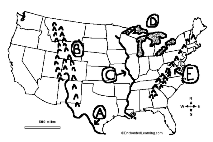
What is the geographical feature labeled with a D?
Rio Grande River
Mississippi River
Great Lakes
Chesapeake Bay

What is the geographical feature labeled with an E?
Appalachian Mountains
Rocky Mountains
Great Lakes
Andes Mountains

What is the geographical feature labeled with a B?
Appalachian Mountains
Rocky Mountains
Blue Ridge Mountains
Himalayan Mountains

What type of map is shown?
Population Map
Climate Map
Physical Map
Political Map

What is this symbol called?
Compass
Compass Rose
Map
Map Scale

What are the lines that go from north to south called?
Longitude Lines
Latitude Lines
Prime Meridians
Equators

What are the names of the three regions of Tennessee?
Western, Middle, Eastern
Memphis Delta, Middle Basin, Eastern Mountains
Northwestern, Southern, and Eastern
Delta, Plateau, Plains

What tool would you use to measure the distance between two places on a map?
key
legend
scale
grid

What is the name of the purple continent?
North America
South America
Africa
Europe

What ocean is located off the East Coast of America?
Atlantic
Pacific
Indian
Southern

The Gulf of Mexico is what direction from the Mississippi River?
West
South
East
North

Which direction is missing?
West
Northwest
North
Northeast
Southwest

What is the name of the orange continent?
Australia
Antarctica
Africa
North America

