
Font size
 Worksheets
South America Study Guide
Total questions: 51
Worksheet time: 39mins
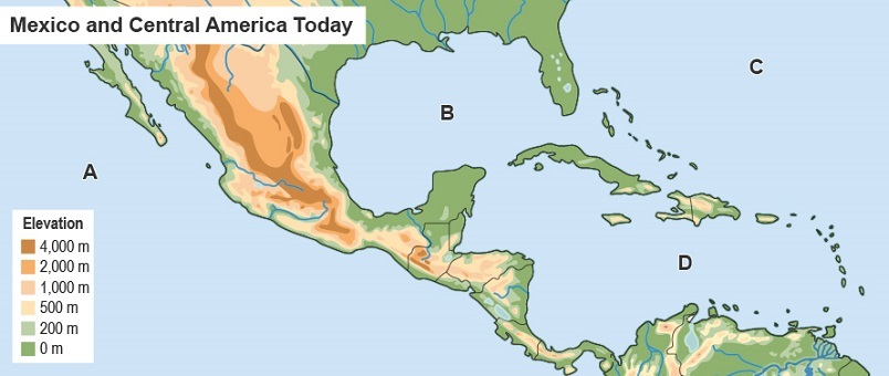
Which letter on the map identifies the Caribbean Sea?
A
B
C
D
Which body of water is located west of Mexico?
the Pacific Ocean
the Gulf of Mexico
the Atlantic Ocean
the Caribbean Sea
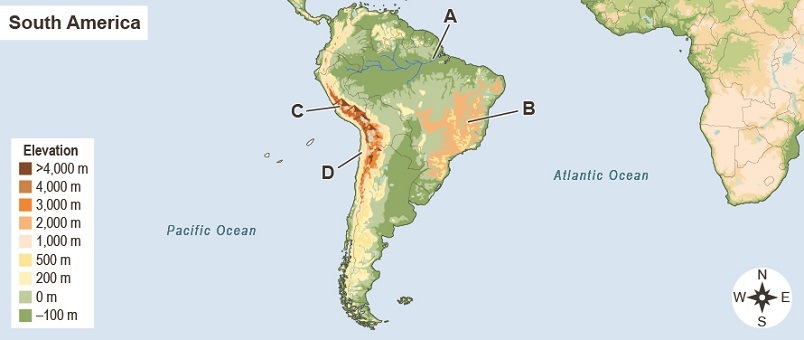
Which letter on the map identifies the location of the Andes Mountains?
A
B
C
D
How are highlands different from lowlands?
Highlands are near the ocean.
Lowlands have a hotter climate.
What is the Isthmus of Panama?
a narrow land bridge in Central America
a mountainous area in South America
Lowlands are more likely to provide transportation for goods because they
are located near mountains.
are located by the ocean.
How did terrace farming allow Mesoamerican people to grow crops effectively?
It allowed them to increase the amount of land they could farm.
It provided a way to farm even in lowland areas with soil of poor quality.
Which physical features most promoted trade between Mesoamerican peoples?
mountains
rivers
How did the physical environment affect the development of cities in Mesoamerica?
Good farmland led to crop surpluses and trade.
Mountain areas allowed for easy road building and other construction.
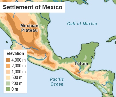
Based on the map, why were the Maya most likely drawn to Tulum?
It was a mountainous area that was suitable for terrace farming.
It was a coastal lowland area that offered transportation routes.
How did the physical environment influence the Olmec?
The location near the Gulf of Mexico allowed for trade with other civilizations.
The tropical climate was poorly suited for farming.
Why were early Mesoamerican societies able to develop specialized jobs?
People did not have to spend all their time farming because they had crop surpluses.
People did not have to exchange goods with other cultures and could do other work.
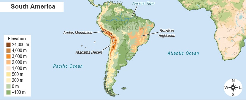
Which statement describes the location of the Atacama Desert?
It is north of the Andes Mountains.
It is west of the Brazilian Highlands.
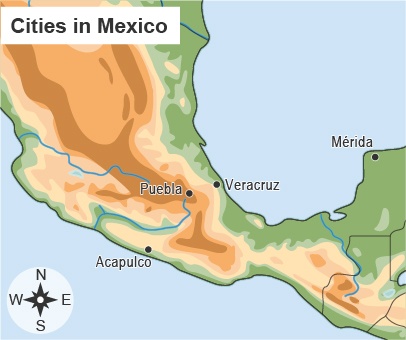
Where is Puebla located in relation to Acapulco?
Puebla is north and east of Acapulco.
Puebla is north and west of Acapulco.
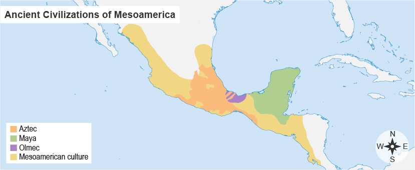
Where was the Olmec civilization located in relation to the Mayan civilization?
to the east
to the west
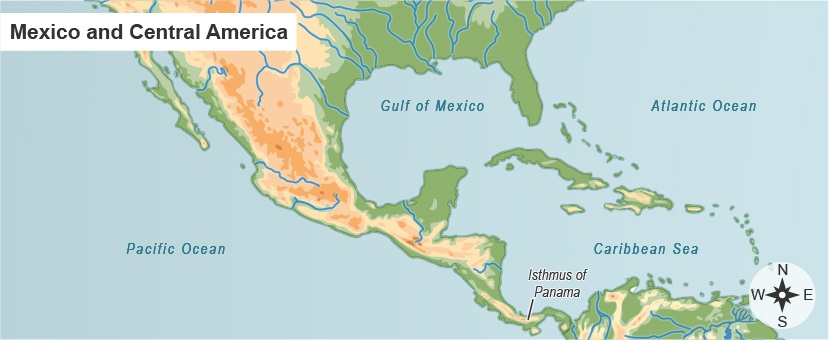
Which statement describes the location of the Isthmus of Panama?
It is east of the Pacific Ocean.
It is north of Belize.

Flag Question: What country's flag is this?
Argentina
Brazil
Peru
Uruguay
Which one is largest in land area?
Nebraska
Texas
Brazil
Colombia

What country is #1?
Colombia
Ecuador
Peru
Venezuela

What is country #2?
Colombia
Venezuela
Peru
Ecuador

What country is #3?
Guyana
Suriname
French Guiana
Peru

What is country #4?
Guyana
Suriname
French Guiana
Colombia

What is country #5?
Guyana
Suriname
French Guiana
Brazil

What is country #6?
Chile
Ecuador
Brazil
Argentina

What country is #7?
Brazil
Chile
Peru
Uruguay

What country is #8?
Argentina
Chile
Brazil
Peru

What country is #9?
Uruguay
Peru
Chile
Argentina

What country is #10?
Paraguay
Uruguay
Bolivia
Venezuala

What country is #11?
Chile
Paraguay
Uruguay
Bolivia

What country is #12?
Ecuador
Peru
Colombia
Argentina

What country is #13?
Ecuador
Colombia
Venezuela
Peru
This South American River Basin is the second largest in the world.
Amazon
Nile
Congo
Grand
Angel Falls is the highest waterfall in the world. What country is it in?
Brazil
Venezuela
Bolivia
Colombia
What kind of activity are the Pampas ideal for?
Mountain Hiking
Skiing
Surfing
Farming
Which ancient civilization built Machu Picchu?
Aztec
Inca
Maya
Taino
What happens during an El Nino?
Wind and ocean currents reverse their usual direction.
The Brazil and Peru Currents collide.
Hot and humid wind currents collide.
Warn and cold wind currents for a dry atmosphere.
What is the longest continuing mountain range in the world?
Rocky Mountains
Himalayan Mountains
Andes Mountains
Allegheny Mountains
There are 2 physically dominate features in South America. What are they?
Angel Falls and Nile River Basin
Amazon River Basin and Nile River
Amazon River Basin and the Andes Mountains
Angel Falls and the Andes Mountains
True of False
The Andes Mountains stretch along the eastern coast of South America.
True
False
What causes the Atacama Desert to be extremely dry?
The Andes Mountains prevent moist winds from reaching the coast of Chile.
The Amazon Basin is too wide for wind currents to reach the desert.
What is the climate like over most of the Amazon River Basin?
hot and humid
hot and windy
hot and dry
humid and cold
Climate in highest elevations of the Andes Mountains.
cool, with little rainfall.
cool, with some rainfall.
warm, with adequate rainfall.
hot with extreme rainfall.
TRUE or FALSE
Most people in South America are most likely to live in WARM, LOW PLACES with SOME RAINFALL.
True
False

USE THE MAP! What geographic feature of northern South America stretches across nearly the entire width of the continent?
Andes Mountains
Amazon River Basin
Pampas Grasslands
a member of a group of people who move from place to place
descendant
tributary
nomad
What did the signing of the Treaty of Tordesillas do?
divided South America's land between Spain and Portugal
gave Columbus permission to sail to South America
permitted the use of enslaved Africans to work on plantations
The Inca were a powerful civilization who lived on South America's west coast. What engineering techniques were used to adapt to their home in the Andes Mountains.
Terraced fields, cut into mountain slopes, allowed Inca to farm
Suspension bridges were built to cross canyons and water.
A system of roads kept the empire together.
All of these engineering techniques were used by the Inca

USE THE MAP!
What geographic pattern do most of South America's densest (most crowded) population areas have in common?
northern location
coastal location
southern location

USE THE MAP! This physical feature covers most of the western side of South America, going through countries like Peru and Chile.
The Andes Mountains
The Amazon River Basin
The Brazilian Highlands
a farming technique used by the Natives to clear lowland areas
slash and burn
terrace fields
hunter-gatherer
The Spanish and Portuguese colonists impacted the Natives by _________________
bringing disease that wiped out villages, converting them to Christianity, and enslaving them
bringing disease that wiped out villages and converting them to Christianity.
bringing disease that wiped out villages, converting them to Muslim, enslaving them

