
 Worksheets
boundaries and topographic maps
Total questions: 9
Worksheet time: 5mins
Name
Class
Date
1.
what is the definition of convergent boundaries?
a)
when two plates move towards each other
b)
when two plates move away form each other
c)
when two plates slide against each other
d)
when one plate sub-ducts another
2.

what is this an example of?
a)
divergent
b)
transform
c)
subduction
d)
convergent
3.
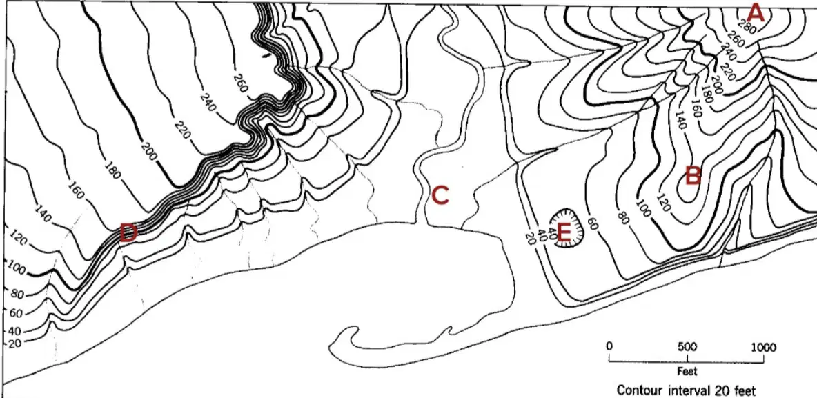
what is the elevation of A
a)
290m
b)
280m
c)
300m
d)
170m
4.
what is elevation?
a)
Height above sea level
b)
Measurement of temperature.
c)
Depth below sea level.
d)
Distance from the equator.
5.
what was Alfred wegners theory called?
a)
drift continental theory
b)
world shape theory
c)
continental drift theory
d)
puzzel piece theory
6.
a transform boundary is when two plates (a) with each other
7.
what is a topographic map?
a)
A topographic map is a map that only shows the political boundaries of different countries.
b)
A topographic map is a type of weather map that shows the current temperature and precipitation.
c)
A topographic map is a map that displays the locations of different tourist attractions.
d)
A topographic map is a detailed and accurate representation of the Earth's surface, showing the physical features such as elevation, relief, and landforms using contour lines.
8.
what is the difference between convergent and divergent boundaries
a)
Convergent boundaries involve plates moving towards each other, while divergent boundaries involve plates colliding or moving away from each other.
b)
Convergent boundaries involve plates moving away from each other, while divergent boundaries involve plates staying still.
c)
Convergent boundaries involve plates colliding or moving towards each other, while divergent boundaries involve plates moving away from each other.
d)
Convergent boundaries involve plates moving away from each other, while divergent boundaries involve plates colliding or moving towards each other.
9.
what is proof of the continental drift theory
a)
Matching shapes of continents, distribution of fossils, alignment of mountain ranges and geological features
b)
Matching shapes of countries, distribution of fossils, alignment of mountain ranges and geological features.
c)
Matching sizes of continents, distribution of fossils, alignment of mountain ranges and geological features.
d)
Matching colors of continents, distribution of fossils, alignment of mountain ranges and geological features.
100 %

