
 Worksheets
Climate and Current Test Review
Total questions: 32
Worksheet time: 17mins
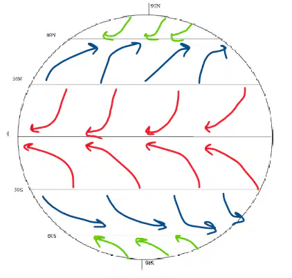
What wind pattern is represented by red arrows in the picture?
Trade winds
Westerlies
PolarEasterlies
PolarWesterlies
What wind pattern is represented by blue arrows in the picture?
Trade winds
Westerlies
PolarEasterlies
PolarWesterlies
What wind pattern is represented by green arrows in the picture?
Trade winds
Westerlies
PolarEasterlies
PolarWesterlies
In the Northern Hemisphere, large-scale motion is deflected which way? (left/right)
left
right
In the Southern Hemisphere, large-scale motion is deflected which way? (left/right)
left
right
Where is the warmest air found?
Near the North Pole
Near the South Pole
Near the Equator
The air temperature is the same everywhere
Which winds are the steadiest?
tradewinds
westerlies
polar easterlies
polar westerlies
Which wind patterns are the most variable winds?
tradewinds
westerlies
polar easterlies
polar westerlies
What is the phenomenon responsible for causing things (like water or air) moving over Earth's surface to travel in a curved line instead of a straight one
Shrödinger's Cat
The Coriolis Effect
gravity
Earth revolving around the sun
The Coriolis effect is caused by the (a) of the planet.
Scale that is used to categorize hurricanes
Eye
Saffir-Simpson
Hurricane watch
Storm surge
Hurricane warning
Issued when there is a threat of hurricane conditions within the next 24-36 hours
Eye
Saffir-Simpson
Hurricane watch
Storm surge
Hurricane warning
Issued when hurricane conditions are expected in an area within the next 24 hours or less
Eye
Saffir-Simpson
Hurricane watch
Storm surge
Hurricane warning
Rise of water above sea level
Eye
Saffir-Simpson
Hurricane watch
Storm surge
Hurricane warning
Calm, cloud and rain-free low pressure center of a hurricane
Eye
Saffir-Simpson
Hurricane watch
Storm surge
Hurricane warning
What direction do hurricanes rotate/spin in the northern hemisphere?
Counterclockwise
Clockwise
What direction do hurricanes rotate/spin in the southern hemisphere?
Counterclockwise
Clockwise
Which of the following correctly describes the motion of a typical Atlantic hurricane?
The storm moves west to east and then turns south
The storm moves east to west and then turns north
The storm moves north and then curves to the east
The storm moves south and then curves to the west
What characteristic of a hurricane causes the most casualties?
Storm surge
Wind
Rainfall
Tornadoes
When is the hurricane season in the Atlantic?
June-November
August-November
January-February
December-March
What is the category of a hurricane with a wind speed of 131-155 mph and a storm surge of 13-18ft?
Category 1
Category 2
Category 3
Category 4

The first picture shows the Pacific Ocean during normal conditions. Which letter represents El Niño?
A
B
both
neither
The first picture shows the Pacific Ocean during normal conditions. Which letter represents La Niña?
A
B
both
neither
Which climate pattern is characterized by the presence of weaker trade winds?
La Niña
El Niño
both
neither
Which climate pattern causes unusually warm and dry winters in the southeastern United States and unusually cold and rainy winters in the Pacific Northwest region of the United States?
El Niño
La Niña
both
neither
Which climate pattern causes unusually cool winters in the southeastern and southwestern United States and unusually warm winters in the Pacific Northwest region of the United States?
El Niño
La Niña
both
neither
El Niño is characterized by a warm ocean current in the Equatorial Pacific Ocean and La Niña is characterized by a cold ocean current in the Equatorial Pacific Ocean
true
false
Winters in the Pacific northwest region of the United States are warmer than usual during what climate pattern?
El Niño
La Niña
How long does an El Niño usually last?
10 years
1-2 years
6 months
100 years
How would a La Niña affect Houston, Texas?
the winter would be warmer and drier, and there would likely be a drought
The winter would be unbearably cold and rainy and lots of flooding would be expected
The summer would be extremely hot and it would likely rain on the coast every day.
The summer would be unusually cold and there would be a drought

What is another name for the Ocean Conveyor Belt?
thermonuclear circulation
thermohaline circulation
halocline
thermocline
What are the driving forces behind the Ocean Conveyor Belt?
Differences in temperature and salinity (therefore density)
wind patterns
the way the water is already moving
water is a polar molecule

